Port Island
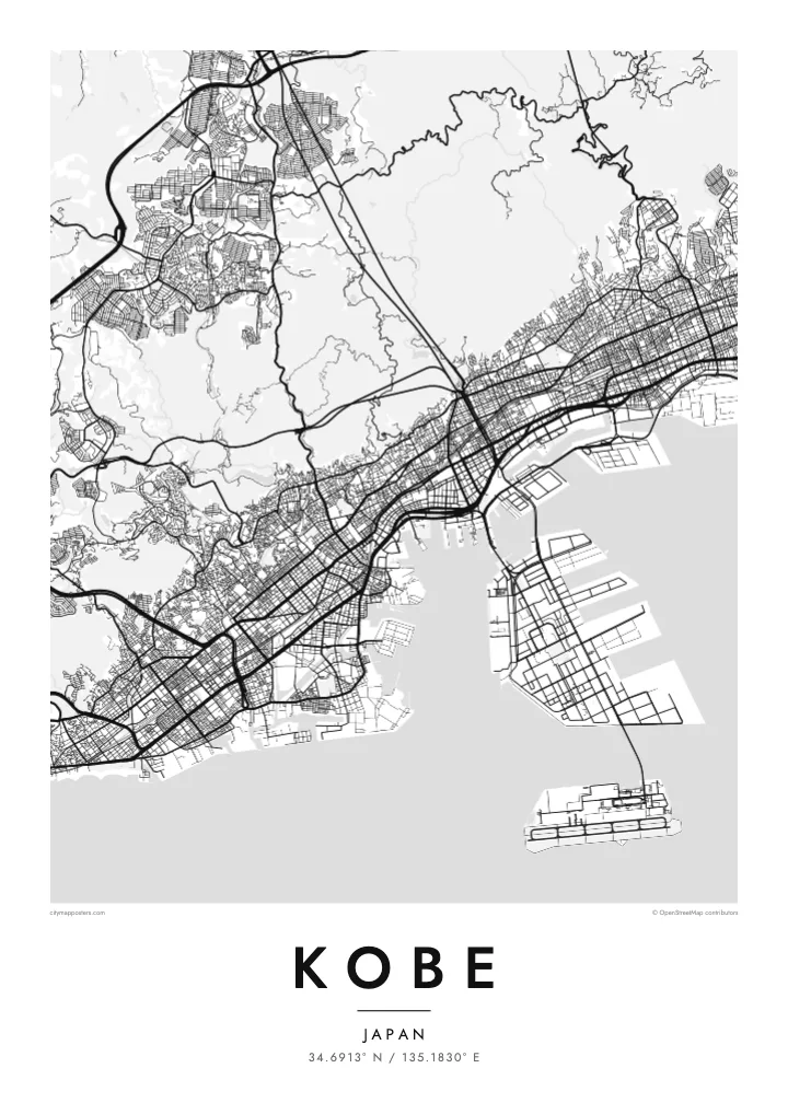
A large artificial island south of the city centre, laid out in regular blocks and linked by bridge. Its straight edges contrast with the natural shoreline.
Minimalist map poster · Japan
34.6913° N / 135.1830° E
A slim port city pressed between the Rokkō mountains and Osaka Bay, with two artificial islands offshore.


One city, five moods
Ekamowa emwit style ouga bwe ouga ekamowa e dedaña ñan bwega. Style otata a kor eangan — eprint, eframe ke HD files.
 Pixel ekwan · 24 × 36″ print file
Print-sharp
Enin 100% crop eo mai print file eo elango. Poster otata — eprint, eframe ke edownload — erender iaan server bwir e 300 DPI, dedaña ñan 7,200 × 10,800 pixels, bwe lane ekekedik ekwan ebwe crisp iaan print 24 × 36″.
Ituro


The map
Kobe is a city of limited width. The Rokkō range rises steeply just behind the centre, so the streets are squeezed into a long band along the shore of Osaka Bay. Railway lines, expressways and main roads all run parallel to the water, while shorter streets climb north toward the slopes, giving the map a clear east–west grain.
The port has long been central to the city's identity. Port Island and Rokkō Island, two large reclaimed islands, extend into the bay as rectangular shapes connected by bridges. Much of the city was rebuilt after the 1995 Great Hanshin earthquake, and on its western edge the Akashi Kaikyō Bridge links Kobe to Awaji Island across the strait.
A Kobe map poster captures a rare composition: dense blocks along a strip of coast, the mountains as a quiet empty space above, and the crisp geometry of the islands below. The Kitano district, with its old foreign merchants' houses, and the harbour at Meriken Park sit within easy reach of one another, all on one sheet.
A large artificial island south of the city centre, laid out in regular blocks and linked by bridge. Its straight edges contrast with the natural shoreline.
The mountain range behind the city, where streets thin out and give way to wooded hills. On the poster it forms a calm upper border.
At the western end of the city, this suspension bridge spans the strait to Awaji Island and adds a slender line of connection across the water.
Make it yours
Add a date, a name or a line of your own, switch style, size or orientation.
Preview ededa low-resolution im watermark. Print im HD files erender iaan 300 DPI, dedaña ñan 7,200 × 10,800 px, ededa watermark.
Why Kobe
Kobe is a city people remember by its slopes and its harbour, whether they grew up there, studied there or arrived by ship. Its narrow shape makes it especially readable as a poster, and it holds up well in both large and small formats.
Add a personal title and subtitle, keep or adjust the coordinates line, and pick from five styles; Noir makes the islands and coastline stand out sharply. Buy the digital files for $9 with no watermark, or order a matte print, framed if you like.
Oder poster Kobe| Print size | Resolution | Files |
|---|---|---|
| 30 × 40 cm (11.8 × 15.7″) | 3,543 × 4,724 px | PNG · PDF |
| 29.7 × 42 cm (A3, 11.7 × 16.5″) | 3,508 × 4,961 px | PNG · PDF |
| 42 × 59.4 cm (A2, 16.5 × 23.4″) | 4,961 × 7,016 px | PNG · PDF |
| 45.7 × 61 cm (18 × 24″) | 5,400 × 7,200 px | PNG · PDF |
| 50 × 70 cm (19.7 × 27.6″) | 5,906 × 8,268 px | PNG · PDF |
| 61 × 91.4 cm (24 × 36″) | 7,200 × 10,800 px | PNG · PDF |
For comparison, the free preview is 900 px wide, watermarked and meant for screens. The HD files have up to 8× the resolution in each direction and print cleanly at full poster size.
Emwit style iaan capña page, im dogen Printed Poster — size eo, im framme ouga tomwin — ke Digital HD Files. Checkout eaer sit step, im order page bwira eupdate iaan payment eo emej.
Eprint iaan matte paper 200 gsm, iaan size eo eo, mai 30 × 40 cm ñan 24 × 36″. Poster eprint eo emeja iaan $39, shipping ededo.
Eko. Emwit frame wood solid iaan black, white, oak natural ke wood dark. Etaña shatterproof glazing im ready ñan hang. Poster eframe emeja iaan $99, shipping ededo.
Eaeoen e ngaaba ngeni ouwa age ngaabe. Ngaeo poster e ibiyaneo ibon e print partner eg ibom ngaen ingi ngae 30+ eben, e naeo e yan ngaae e 3–7 aon wan ewa. Kom ngaa e eain ingi tracking ibon My Orders. Tauweo ebe 2–5 wik, ingi ibon ngaen ibun e ngaeo ngaeigie, e saet e sooe nuwe kom e pae.
Kabun photo bwira iaan 14 aean mai delivery, im bwira ereprint ededo ke erefund.
Eko. Iaan editor page eanin, ouga change title, subtitle, im coordinates line ñan tomwin ouga koda, im emwit style im size. Order eprint, eframe im digital otata ekamowa design ouga tomwin.
Iaan $9 ouga ereub 300 DPI PNG im PDF print-ready iaan size otata eo, ededa watermark, ñan print ekamowa tomwin. Ouga aewedik? Download preview ededa watermarked kabun.
