Doshisha campus
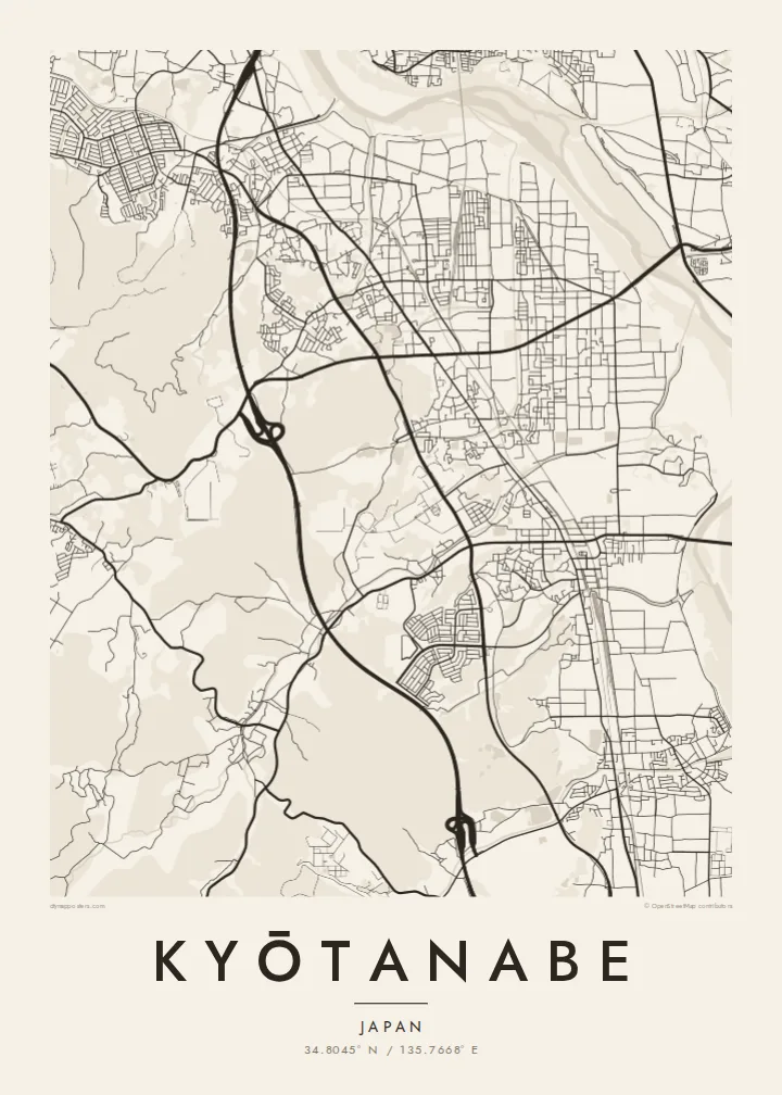
On the western hills, the university's Kyotanabe campus forms a large, clearly bounded area with its own internal roads and open spaces.
Minimalist map poster · Japan
34.8045° N / 135.7668° E
A long north–south town between Kyoto and Nara, shaped by parallel rail lines, the Kizu River and a hillside university campus.




One city, five moods
Ekamowa emwit style ouga bwe ouga ekamowa e dedaña ñan bwega. Style otata a kor eangan — eprint, eframe ke HD files.
 Pixel ekwan · 24 × 36″ print file
Print-sharp
Enin 100% crop eo mai print file eo elango. Poster otata — eprint, eframe ke edownload — erender iaan server bwir e 300 DPI, dedaña ñan 7,200 × 10,800 pixels, bwe lane ekekedik ekwan ebwe crisp iaan print 24 × 36″.
Ituro


The map
Kyōtanabe stretches along the corridor between Kyoto and Nara, and its map is organised by lines running north to south. Two railways, the JR Gakkentoshi Line and the Kintetsu Kyoto Line, run through the town, and residential neighbourhoods have grown up around their stations. To the east, the Kizu River runs along the edge of the municipality, flanked by embankments and open ground.
To the west, the land rises into low hills, where the large Kyotanabe campus of Doshisha University occupies a broad area of paths and buildings. Between the hills and the river, housing estates, farmland and older village centres mix together, giving the map a varied texture. Tea is still grown in the surrounding area, part of the southern Kyoto tea-growing tradition.
The town is also home to Ikkyū-ji, the temple where the Zen monk Ikkyū spent his final years. A Kyōtanabe map poster captures the shape of a commuter town that still keeps traces of an older rural landscape, with rail, river and hills defining its outline more clearly than any single centre.
On the western hills, the university's Kyotanabe campus forms a large, clearly bounded area with its own internal roads and open spaces.
Along the eastern edge, the river and its embankments form a long, flowing line that sets the town's boundary against the neighbouring municipalities.
The temple associated with the monk Ikkyū sits in a quieter part of town, a small precinct set apart from the grid of newer neighbourhoods.
Make it yours
Add a date, a name or a line of your own, switch style, size or orientation.
Preview ededa low-resolution im watermark. Print im HD files erender iaan 300 DPI, dedaña ñan 7,200 × 10,800 px, ededa watermark.
Why Kyōtanabe
For Doshisha students and graduates, Kyōtanabe is where years of study took place, and for residents it is a calm home between two historic cities. The map suits a graduation, a first apartment or a family house.
The title and subtitle can hold a name, a year or a station, and the coordinates line can be edited. Choose one of five styles; Classic black & white keeps the rail lines sharp, and Paper softens the whole plan.
Oder poster Kyōtanabe| Print size | Resolution | Files |
|---|---|---|
| 30 × 40 cm11.8 × 15.7″ | 3,543 × 4,724 px | PNG · PDF |
| 29.7 × 42 cm (A3)11.7 × 16.5″ | 3,508 × 4,961 px | PNG · PDF |
| 42 × 59.4 cm (A2)16.5 × 23.4″ | 4,961 × 7,016 px | PNG · PDF |
| 45.7 × 61 cm18 × 24″ | 5,400 × 7,200 px | PNG · PDF |
| 50 × 70 cm19.7 × 27.6″ | 5,906 × 8,268 px | PNG · PDF |
| 61 × 91.4 cm24 × 36″ | 7,200 × 10,800 px | PNG · PDF |
For comparison, the free preview is 900 px wide, watermarked and meant for screens. The HD files have up to 8× the resolution in each direction and print cleanly at full poster size.
Emwit style iaan capña page, im dogen Printed Poster — size eo, im framme ouga tomwin — ke Digital HD Files. Checkout eaer sit step, im order page bwira eupdate iaan payment eo emej.
Eprint iaan matte paper 200 gsm, iaan size eo eo, mai 30 × 40 cm ñan 24 × 36″. Poster eprint eo emeja iaan $39, shipping ededo.
Eko. Emwit frame wood solid iaan black, white, oak natural ke wood dark. Etaña shatterproof glazing im ready ñan hang. Poster eframe emeja iaan $99, shipping ededo.
Shipping ma free ägen 60+ country. Poster ngaga eo e print ägen print partner nearest ibiema 30+ country, ae e tep ägen 3–7 business day. Ngaga kor status ae tracking ibe My Orders. Country ibiema e tep 2–5 week, ae country ngaga ibe shipping e bwaren, website e ibin oen bwa ngaga pay.
Kabun photo bwira iaan 14 aean mai delivery, im bwira ereprint ededo ke erefund.
Eko. Iaan editor page eanin, ouga change title, subtitle, im coordinates line ñan tomwin ouga koda, im emwit style im size. Order eprint, eframe im digital otata ekamowa design ouga tomwin.
Iaan $9 ouga ereub 300 DPI PNG im PDF print-ready iaan size otata eo, ededa watermark, ñan print ekamowa tomwin. Ouga aewedik? Download preview ededa watermarked kabun.
