Santa Monica Mountains
A ridge of hills runs east to west through the city, separating the basin from the Valley, with Mulholland Drive winding along its crest.
Minimalist map poster · United States
34.0522° N / 118.2437° W
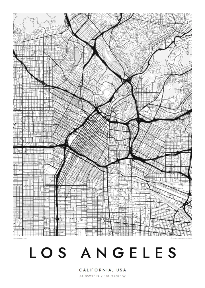
An immense grid of boulevards and freeways across a coastal basin, split by mountains and bordered by the Pacific.


One city, five moods
Ekamowa emwit style ouga bwe ouga ekamowa e dedaña ñan bwega. Style otata a kor eangan — eprint, eframe ke HD files.
 Pixel ekwan · 24 × 36″ print file
Print-sharp
Enin 100% crop eo mai print file eo elango. Poster otata — eprint, eframe ke edownload — erender iaan server bwir e 300 DPI, dedaña ñan 7,200 × 10,800 pixels, bwe lane ekekedik ekwan ebwe crisp iaan print 24 × 36″.
Ituro


The map
Los Angeles covers a huge area, and from above it reads as one of the largest continuous street grids anywhere. Long boulevards such as Wilshire, Sunset and Venice run for many miles across the basin, and the freeways cut diagonals and curves through that pattern. The city boundary itself is irregular, weaving around independent cities like Santa Monica and Beverly Hills.
The Santa Monica Mountains divide the basin from the San Fernando Valley, and on the map their dark, winding ridge roads stand out against the regular blocks on either side. At the eastern end of the range, Griffith Park forms one of the largest urban parks in the country, while the Los Angeles River runs through the city in a long concrete channel.
A narrow strip of city land, often called the Shoestring, runs south to connect Los Angeles with its harbour at San Pedro. A Los Angeles map poster makes this unusual shape clear, along with the coastline from Venice to Pacific Palisades. It is a city many people know by car, and the map shows those routes in a way the windshield never does.
A ridge of hills runs east to west through the city, separating the basin from the Valley, with Mulholland Drive winding along its crest.
Long, straight streets like Wilshire and Sunset cross the basin for miles, forming a grid so large it fills the poster from edge to edge.
A narrow corridor of city land reaches south to the Port of Los Angeles at San Pedro, one of the strangest and most recognisable municipal boundaries in the country.
Make it yours
Add a date, a name or a line of your own, switch style, size or orientation.
Preview ededa low-resolution im watermark. Print im HD files erender iaan 300 DPI, dedaña ñan 7,200 × 10,800 px, ededa watermark.
Why Los Angeles
Los Angeles is a city of neighbourhoods, and a map poster lets you mark your own: a first apartment in Silver Lake, a job in Hollywood, a house near the beach in Venice. The clean grid looks sharp in a home office or living room.
Write your own title and subtitle, add a date or coordinates, and choose Classic black & white, Noir, Paper, Blueprint or Sand. The $9 HD files include 18×24″ and 24×36″ sizes, and printed posters ship from partners in 30+ countries.
Oder poster Los Angeles| Print size | Resolution | Files |
|---|---|---|
| 30 × 40 cm11.8 × 15.7″ | 3,543 × 4,724 px | PNG · PDF |
| 29.7 × 42 cm (A3)11.7 × 16.5″ | 3,508 × 4,961 px | PNG · PDF |
| 42 × 59.4 cm (A2)16.5 × 23.4″ | 4,961 × 7,016 px | PNG · PDF |
| 45.7 × 61 cm18 × 24″ | 5,400 × 7,200 px | PNG · PDF |
| 50 × 70 cm19.7 × 27.6″ | 5,906 × 8,268 px | PNG · PDF |
| 61 × 91.4 cm24 × 36″ | 7,200 × 10,800 px | PNG · PDF |
For comparison, the free preview is 900 px wide, watermarked and meant for screens. The HD files have up to 8× the resolution in each direction and print cleanly at full poster size.
Emwit style iaan capña page, im dogen Printed Poster — size eo, im framme ouga tomwin — ke Digital HD Files. Checkout eaer sit step, im order page bwira eupdate iaan payment eo emej.
Eprint iaan matte paper 200 gsm, iaan size eo eo, mai 30 × 40 cm ñan 24 × 36″. Poster eprint eo emeja iaan $39, shipping ededo.
Eko. Emwit frame wood solid iaan black, white, oak natural ke wood dark. Etaña shatterproof glazing im ready ñan hang. Poster eframe emeja iaan $99, shipping ededo.
Shipping ma free ägen 60+ country. Poster ngaga eo e print ägen print partner nearest ibiema 30+ country, ae e tep ägen 3–7 business day. Ngaga kor status ae tracking ibe My Orders. Country ibiema e tep 2–5 week, ae country ngaga ibe shipping e bwaren, website e ibin oen bwa ngaga pay.
Kabun photo bwira iaan 14 aean mai delivery, im bwira ereprint ededo ke erefund.
Eko. Iaan editor page eanin, ouga change title, subtitle, im coordinates line ñan tomwin ouga koda, im emwit style im size. Order eprint, eframe im digital otata ekamowa design ouga tomwin.
Iaan $9 ouga ereub 300 DPI PNG im PDF print-ready iaan size otata eo, ededa watermark, ñan print ekamowa tomwin. Ouga aewedik? Download preview ededa watermarked kabun.
