Nieuwe Waterweg
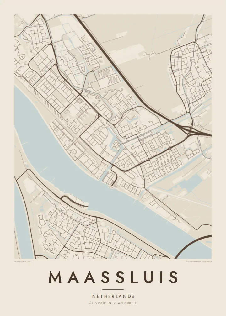
The wide shipping channel runs along the town's southern side, one of the busiest waterways in Europe, and forms a bold band across the bottom of the poster.
Minimalist map poster · Netherlands
51.9233° N / 4.2500° E
A harbour town on the Nieuwe Waterweg, with an old sluice-side core, straight dikes and polders opening behind the river.


One city, five moods
Ekamowa emwit style ouga bwe ouga ekamowa e dedaña ñan bwega. Style otata a kor eangan — eprint, eframe ke HD files.
 Pixel ekwan · 24 × 36″ print file
Print-sharp
Enin 100% crop eo mai print file eo elango. Poster otata — eprint, eframe ke edownload — erender iaan server bwir e 300 DPI, dedaña ñan 7,200 × 10,800 pixels, bwe lane ekekedik ekwan ebwe crisp iaan print 24 × 36″.
Ituro


The map
Maassluis sits on the north bank of the Nieuwe Waterweg, the wide shipping channel that links Rotterdam to the North Sea. From above, the river forms a broad, dark band along the southern edge of the town. The old harbour cuts inland from it, surrounded by the tight streets of the historic centre, and the rest of the town extends north into the flat Dutch polder landscape.
The name refers to the sluice that once let water from the polders drain into the river. Water management still sets the pattern here, with dikes, ditches and straight drainage lines across the surrounding land. The town has long been associated with tugboats and maritime work, and ships moving to and from Rotterdam pass close to its quays.
A Maassluis map poster shows the contrast between that major waterway and the small, careful street network behind it. The harbour basin, the dike roads and the geometric polder edges produce a map with clean straight lines and one strong horizontal river. It is Dutch landscape design seen from above.
The wide shipping channel runs along the town's southern side, one of the busiest waterways in Europe, and forms a bold band across the bottom of the poster.
A narrow basin reaches inland from the river into the historic centre. The oldest streets and quays cluster close around it in a small, dense pattern.
North of the built-up area, straight ditches and roads divide the reclaimed land into long rectangles, a pattern typical of South Holland that looks crisp in black and white.
Make it yours
Add a date, a name or a line of your own, switch style, size or orientation.
Preview ededa low-resolution im watermark. Print im HD files erender iaan 300 DPI, dedaña ñan 7,200 × 10,800 px, ededa watermark.
Why Maassluis
If you have lived by the Waterweg and watched ships pass behind the dike, this map will look familiar. It also appeals to anyone who likes how the Dutch have drawn their land with rulers and water.
Personalise the title, subtitle and coordinates, perhaps with a harbour name or the year of a move. The five styles range from Classic black & white to Noir, which gives the river a deep, dark presence.
Oder poster Maassluis| Print size | Resolution | Files |
|---|---|---|
| 30 × 40 cm11.8 × 15.7″ | 3,543 × 4,724 px | PNG · PDF |
| 29.7 × 42 cm (A3)11.7 × 16.5″ | 3,508 × 4,961 px | PNG · PDF |
| 42 × 59.4 cm (A2)16.5 × 23.4″ | 4,961 × 7,016 px | PNG · PDF |
| 45.7 × 61 cm18 × 24″ | 5,400 × 7,200 px | PNG · PDF |
| 50 × 70 cm19.7 × 27.6″ | 5,906 × 8,268 px | PNG · PDF |
| 61 × 91.4 cm24 × 36″ | 7,200 × 10,800 px | PNG · PDF |
For comparison, the free preview is 900 px wide, watermarked and meant for screens. The HD files have up to 8× the resolution in each direction and print cleanly at full poster size.
Emwit style iaan capña page, im dogen Printed Poster — size eo, im framme ouga tomwin — ke Digital HD Files. Checkout eaer sit step, im order page bwira eupdate iaan payment eo emej.
Eprint iaan matte paper 200 gsm, iaan size eo eo, mai 30 × 40 cm ñan 24 × 36″. Poster eprint eo emeja iaan $39, shipping ededo.
Eko. Emwit frame wood solid iaan black, white, oak natural ke wood dark. Etaña shatterproof glazing im ready ñan hang. Poster eframe emeja iaan $99, shipping ededo.
Shipping ma free ägen 60+ country. Poster ngaga eo e print ägen print partner nearest ibiema 30+ country, ae e tep ägen 3–7 business day. Ngaga kor status ae tracking ibe My Orders. Country ibiema e tep 2–5 week, ae country ngaga ibe shipping e bwaren, website e ibin oen bwa ngaga pay.
Kabun photo bwira iaan 14 aean mai delivery, im bwira ereprint ededo ke erefund.
Eko. Iaan editor page eanin, ouga change title, subtitle, im coordinates line ñan tomwin ouga koda, im emwit style im size. Order eprint, eframe im digital otata ekamowa design ouga tomwin.
Iaan $9 ouga ereub 300 DPI PNG im PDF print-ready iaan size otata eo, ededa watermark, ñan print ekamowa tomwin. Ouga aewedik? Download preview ededa watermarked kabun.
