Niger River border
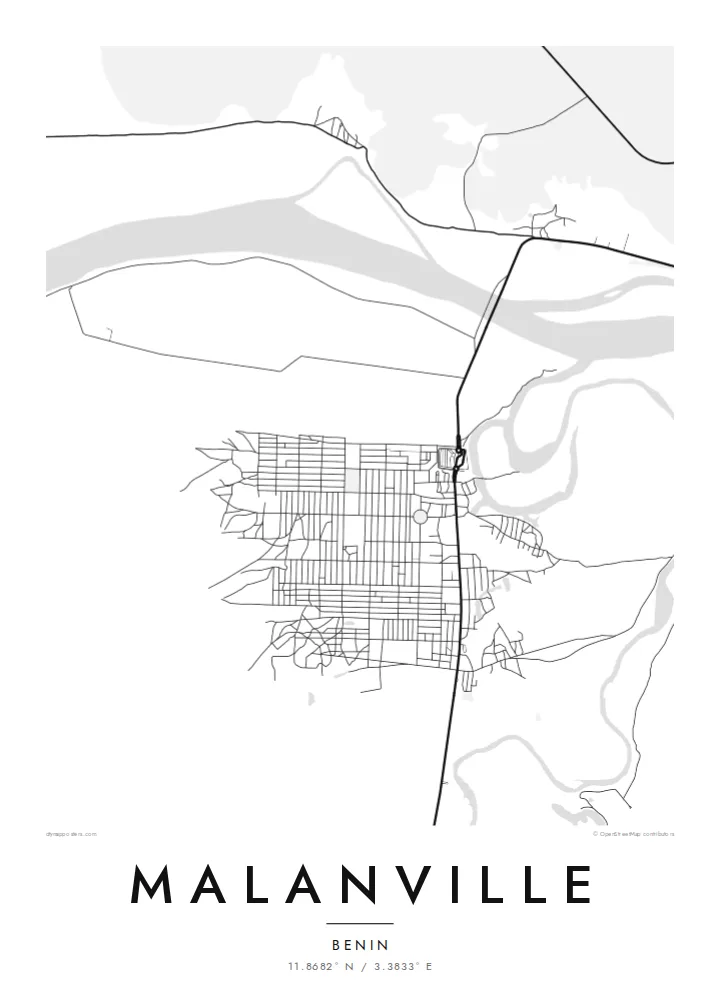
The broad Niger runs along the northern edge of the town and marks the international boundary. Its braided channels and sandbanks give the top of the print texture and movement.
Minimalist map poster · Benin
11.8682° N / 3.3833° E
Benin's northern gateway on the Niger River, a market town facing the neighbouring country across the water


One city, five moods
Ekamowa emwit style ouga bwe ouga ekamowa e dedaña ñan bwega. Style otata a kor eangan — eprint, eframe ke HD files.
 Pixel ekwan · 24 × 36″ print file
Print-sharp
Enin 100% crop eo mai print file eo elango. Poster otata — eprint, eframe ke edownload — erender iaan server bwir e 300 DPI, dedaña ñan 7,200 × 10,800 pixels, bwe lane ekekedik ekwan ebwe crisp iaan print 24 × 36″.
Ituro


The map
Malanville is at the northern tip of Benin, where the Niger River forms the border with the Republic of Niger. From above, the river is the dominant feature: a wide channel with sandbanks and side branches. A bridge carries the main road north across it. The town spreads along the southern bank in a loose grid, and flat, cultivated floodplain fills the space between streets and water.
The town is best known for its large regional market, which draws traders from Benin, Niger, Nigeria and further afield. It also sits on the main road corridor linking the Gulf of Guinea coast with the Sahel. The Malanville map poster shows that meeting point clearly: a river, a bridge and a road that ties two countries together.
Around the town, the floodplain is worked for rice and other crops. On a clean monochrome map it shows as open ground crossed by channels. To the west lies the wider Niger valley, and protected parkland is not far away. The print leaves out everything except structure: a town set between the river and the long road south.
The broad Niger runs along the northern edge of the town and marks the international boundary. Its braided channels and sandbanks give the top of the print texture and movement.
The road bridge over the Niger connects Malanville with the town of Gaya on the opposite bank. It is a short, decisive line that joins two countries.
The streets form a loose, practical grid around the market district. It is the densest part of the map, where regional trade gathers every week.
Make it yours
Add a date, a name or a line of your own, switch style, size or orientation.
Preview ededa low-resolution im watermark. Print im HD files erender iaan 300 DPI, dedaña ñan 7,200 × 10,800 px, ededa watermark.
Why Malanville
For anyone who has crossed the Niger here, traded at the market or grown up in Alibori, this map records a place defined by movement and exchange. The river-and-bridge composition works well in a living room or an office.
Personalise the title, subtitle and coordinates line with a name or date that matters to you. Choose one of five styles: Classic black & white, Noir, Paper, Blueprint or Sand. Printed posters on matte paper ship from partners in more than 30 countries.
Oder poster Malanville| Print size | Resolution | Files |
|---|---|---|
| 30 × 40 cm11.8 × 15.7″ | 3,543 × 4,724 px | PNG · PDF |
| 29.7 × 42 cm (A3)11.7 × 16.5″ | 3,508 × 4,961 px | PNG · PDF |
| 42 × 59.4 cm (A2)16.5 × 23.4″ | 4,961 × 7,016 px | PNG · PDF |
| 45.7 × 61 cm18 × 24″ | 5,400 × 7,200 px | PNG · PDF |
| 50 × 70 cm19.7 × 27.6″ | 5,906 × 8,268 px | PNG · PDF |
| 61 × 91.4 cm24 × 36″ | 7,200 × 10,800 px | PNG · PDF |
For comparison, the free preview is 900 px wide, watermarked and meant for screens. The HD files have up to 8× the resolution in each direction and print cleanly at full poster size.
Emwit style iaan capña page, im dogen Printed Poster — size eo, im framme ouga tomwin — ke Digital HD Files. Checkout eaer sit step, im order page bwira eupdate iaan payment eo emej.
Eprint iaan matte paper 200 gsm, iaan size eo eo, mai 30 × 40 cm ñan 24 × 36″. Poster eprint eo emeja iaan $39, shipping ededo.
Eko. Emwit frame wood solid iaan black, white, oak natural ke wood dark. Etaña shatterproof glazing im ready ñan hang. Poster eframe emeja iaan $99, shipping ededo.
Shipping ma free ägen 60+ country. Poster ngaga eo e print ägen print partner nearest ibiema 30+ country, ae e tep ägen 3–7 business day. Ngaga kor status ae tracking ibe My Orders. Country ibiema e tep 2–5 week, ae country ngaga ibe shipping e bwaren, website e ibin oen bwa ngaga pay.
Kabun photo bwira iaan 14 aean mai delivery, im bwira ereprint ededo ke erefund.
Eko. Iaan editor page eanin, ouga change title, subtitle, im coordinates line ñan tomwin ouga koda, im emwit style im size. Order eprint, eframe im digital otata ekamowa design ouga tomwin.
Iaan $9 ouga ereub 300 DPI PNG im PDF print-ready iaan size otata eo, ededa watermark, ñan print ekamowa tomwin. Ouga aewedik? Download preview ededa watermarked kabun.
