The border crossing
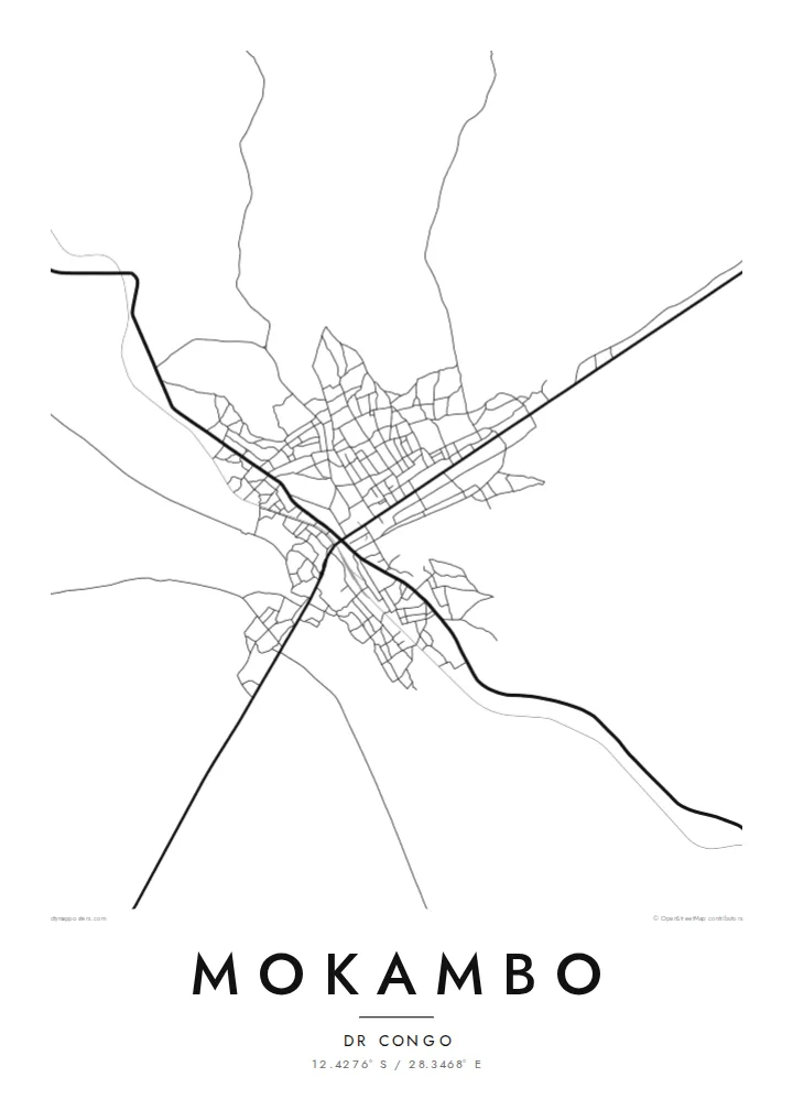
Roads draw together at the frontier with Zambia. The way routes funnel toward a single point is the clearest structure on the map and gives the town its purpose.
Minimalist map poster · Congo - Kinshasa
12.4276° S / 28.3468° E
A small border town in the Copperbelt, where a handful of roads gather at the line between Congo and Zambia


One city, five moods
Ekamowa emwit style ouga bwe ouga ekamowa e dedaña ñan bwega. Style otata a kor eangan — eprint, eframe ke HD files.
 Pixel ekwan · 24 × 36″ print file
Print-sharp
Enin 100% crop eo mai print file eo elango. Poster otata — eprint, eframe ke edownload — erender iaan server bwir e 300 DPI, dedaña ñan 7,200 × 10,800 pixels, bwe lane ekekedik ekwan ebwe crisp iaan print 24 × 36″.
Ituro


The map
Mokambo lies in Haut-Katanga province in the far south of the Democratic Republic of the Congo, right on the border with Zambia. On a map it appears as a modest settlement shaped by roads rather than rivers or coastlines, with streets converging on the crossing point and spreading into scattered housing on either side.
The surrounding landscape is the wooded plateau of the Copperbelt, a region defined by mining and by the roads that link its towns. From above, the pattern is loose and practical: a few main routes, smaller tracks branching off them, and open ground between clusters of buildings. The international boundary itself is invisible on the ground but organises everything around it.
A Mokambo map poster is a spare composition. There is no dense grid or old quarter to fill the frame, so the print relies on the thin lines of roads crossing open land. That restraint suits minimalist design well, and it gives the image a calm, almost diagrammatic quality that reads clearly from across a room.
Roads draw together at the frontier with Zambia. The way routes funnel toward a single point is the clearest structure on the map and gives the town its purpose.
The town sits on the high, gently rolling ground of the Copperbelt. The map shows few natural barriers, so streets extend freely in the directions trade and travel require.
Buildings cluster along roads with generous gaps between them. On a black-and-white print this becomes a light, airy image with long lines and plenty of white space.
Make it yours
Add a date, a name or a line of your own, switch style, size or orientation.
Preview ededa low-resolution im watermark. Print im HD files erender iaan 300 DPI, dedaña ñan 7,200 × 10,800 px, ededa watermark.
Why Mokambo
A map of Mokambo is a personal choice, usually made by someone who lived, worked or crossed the border there. It holds a specific place in a way a photograph of the region cannot, and it stays understated on a wall.
The title, subtitle and coordinates can all be personalised, so the poster can carry a name, a year or a short dedication. Choose from Classic black and white, Noir, Paper, Blueprint or Sand to suit the room.
Oder poster Mokambo| Print size | Resolution | Files |
|---|---|---|
| 30 × 40 cm (11.8 × 15.7″) | 3,543 × 4,724 px | PNG · PDF |
| 29.7 × 42 cm (A3, 11.7 × 16.5″) | 3,508 × 4,961 px | PNG · PDF |
| 42 × 59.4 cm (A2, 16.5 × 23.4″) | 4,961 × 7,016 px | PNG · PDF |
| 45.7 × 61 cm (18 × 24″) | 5,400 × 7,200 px | PNG · PDF |
| 50 × 70 cm (19.7 × 27.6″) | 5,906 × 8,268 px | PNG · PDF |
| 61 × 91.4 cm (24 × 36″) | 7,200 × 10,800 px | PNG · PDF |
For comparison, the free preview is 900 px wide, watermarked and meant for screens. The HD files have up to 8× the resolution in each direction and print cleanly at full poster size.
Emwit style iaan capña page, im dogen Printed Poster — size eo, im framme ouga tomwin — ke Digital HD Files. Checkout eaer sit step, im order page bwira eupdate iaan payment eo emej.
Eprint iaan matte paper 200 gsm, iaan size eo eo, mai 30 × 40 cm ñan 24 × 36″. Poster eprint eo emeja iaan $39, shipping ededo.
Eko. Emwit frame wood solid iaan black, white, oak natural ke wood dark. Etaña shatterproof glazing im ready ñan hang. Poster eframe emeja iaan $99, shipping ededo.
Eaeoen e ngaaba ngeni ouwa age ngaabe. Ngaeo poster e ibiyaneo ibon e print partner eg ibom ngaen ingi ngae 30+ eben, e naeo e yan ngaae e 3–7 aon wan ewa. Kom ngaa e eain ingi tracking ibon My Orders. Tauweo ebe 2–5 wik, ingi ibon ngaen ibun e ngaeo ngaeigie, e saet e sooe nuwe kom e pae.
Kabun photo bwira iaan 14 aean mai delivery, im bwira ereprint ededo ke erefund.
Eko. Iaan editor page eanin, ouga change title, subtitle, im coordinates line ñan tomwin ouga koda, im emwit style im size. Order eprint, eframe im digital otata ekamowa design ouga tomwin.
Iaan $9 ouga ereub 300 DPI PNG im PDF print-ready iaan size otata eo, ededa watermark, ñan print ekamowa tomwin. Ouga aewedik? Download preview ededa watermarked kabun.
