Northern settlements
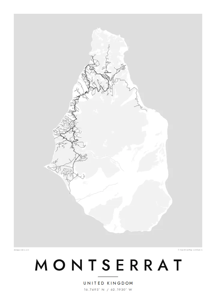
Brades, Little Bay and the surrounding villages gather most of the island's roads in the north, where winding lanes follow the ridges and valleys of the Silver and Centre Hills.
Minimalist map poster · United Kingdom
16.7493° N / 62.1930° W
A small, pear-shaped Caribbean island whose green northern hills hold the towns while the volcanic south lies closed.


One city, five moods
Ekamowa emwit style ouga bwe ouga ekamowa e dedaña ñan bwega. Style otata a kor eangan — eprint, eframe ke HD files.
 Pixel ekwan · 24 × 36″ print file
Print-sharp
Enin 100% crop eo mai print file eo elango. Poster otata — eprint, eframe ke edownload — erender iaan server bwir e 300 DPI, dedaña ñan 7,200 × 10,800 pixels, bwe lane ekekedik ekwan ebwe crisp iaan print 24 × 36″.
Ituro


The map
Montserrat is a British Overseas Territory in the Leeward Islands, around sixteen kilometres from north to south. Its shape narrows toward the north, and three groups of hills run down its length: the Silver Hills at the northern tip, the forested Centre Hills in the middle and the Soufrière Hills in the south. It has long been called the Emerald Isle of the Caribbean, partly for its Irish heritage.
Since 1995 the Soufrière Hills volcano has reshaped the island. Eruptions buried the former capital, Plymouth, and much of the south became an exclusion zone. A Montserrat map poster therefore shows an unusual pattern: roads and villages concentrated in the north, around Brades and Little Bay, and a southern half where the streets of the abandoned capital sit cut off from the rest of the network.
Life on the island moved north after the eruptions, and a new airport, new housing and a small port were built there. The volcano is still monitored closely, and the landscape around it continues to change with each period of activity. The result on paper is a map that records both an island and a recent turn in its history.
Brades, Little Bay and the surrounding villages gather most of the island's roads in the north, where winding lanes follow the ridges and valleys of the Silver and Centre Hills.
The volcano dominates the southern half, its slopes left largely without roads. On the poster this area reads as open ground, a clear graphic contrast with the settled north.
The former capital on the southwest coast was abandoned after the 1997 eruptions. Its street pattern still shows on the map, isolated inside the exclusion zone.
Make it yours
Add a date, a name or a line of your own, switch style, size or orientation.
Preview ededa low-resolution im watermark. Print im HD files erender iaan 300 DPI, dedaña ñan 7,200 × 10,800 px, ededa watermark.
Why Montserrat
People with family ties to Montserrat, and those who knew it before 1995, often want a map that shows the whole island rather than only its settled part. The compact outline fits comfortably on any of the print sizes and keeps its detail.
The title, subtitle and coordinates line can all be changed, so the poster might carry a family village or a year that matters. Pick one of five styles, Classic, Noir, Paper, Blueprint or Sand, then download 300 DPI files for $9 or order a printed poster with an optional wooden frame.
Oder poster Montserrat| Print size | Resolution | Files |
|---|---|---|
| 30 × 40 cm11.8 × 15.7″ | 3,543 × 4,724 px | PNG · PDF |
| 29.7 × 42 cm (A3)11.7 × 16.5″ | 3,508 × 4,961 px | PNG · PDF |
| 42 × 59.4 cm (A2)16.5 × 23.4″ | 4,961 × 7,016 px | PNG · PDF |
| 45.7 × 61 cm18 × 24″ | 5,400 × 7,200 px | PNG · PDF |
| 50 × 70 cm19.7 × 27.6″ | 5,906 × 8,268 px | PNG · PDF |
| 61 × 91.4 cm24 × 36″ | 7,200 × 10,800 px | PNG · PDF |
For comparison, the free preview is 900 px wide, watermarked and meant for screens. The HD files have up to 8× the resolution in each direction and print cleanly at full poster size.
Emwit style iaan capña page, im dogen Printed Poster — size eo, im framme ouga tomwin — ke Digital HD Files. Checkout eaer sit step, im order page bwira eupdate iaan payment eo emej.
Eprint iaan matte paper 200 gsm, iaan size eo eo, mai 30 × 40 cm ñan 24 × 36″. Poster eprint eo emeja iaan $39, shipping ededo.
Eko. Emwit frame wood solid iaan black, white, oak natural ke wood dark. Etaña shatterproof glazing im ready ñan hang. Poster eframe emeja iaan $99, shipping ededo.
Shipping ma free ägen 60+ country. Poster ngaga eo e print ägen print partner nearest ibiema 30+ country, ae e tep ägen 3–7 business day. Ngaga kor status ae tracking ibe My Orders. Country ibiema e tep 2–5 week, ae country ngaga ibe shipping e bwaren, website e ibin oen bwa ngaga pay.
Kabun photo bwira iaan 14 aean mai delivery, im bwira ereprint ededo ke erefund.
Eko. Iaan editor page eanin, ouga change title, subtitle, im coordinates line ñan tomwin ouga koda, im emwit style im size. Order eprint, eframe im digital otata ekamowa design ouga tomwin.
Iaan $9 ouga ereub 300 DPI PNG im PDF print-ready iaan size otata eo, ededa watermark, ñan print ekamowa tomwin. Ouga aewedik? Download preview ededa watermarked kabun.
