Temple-centred core
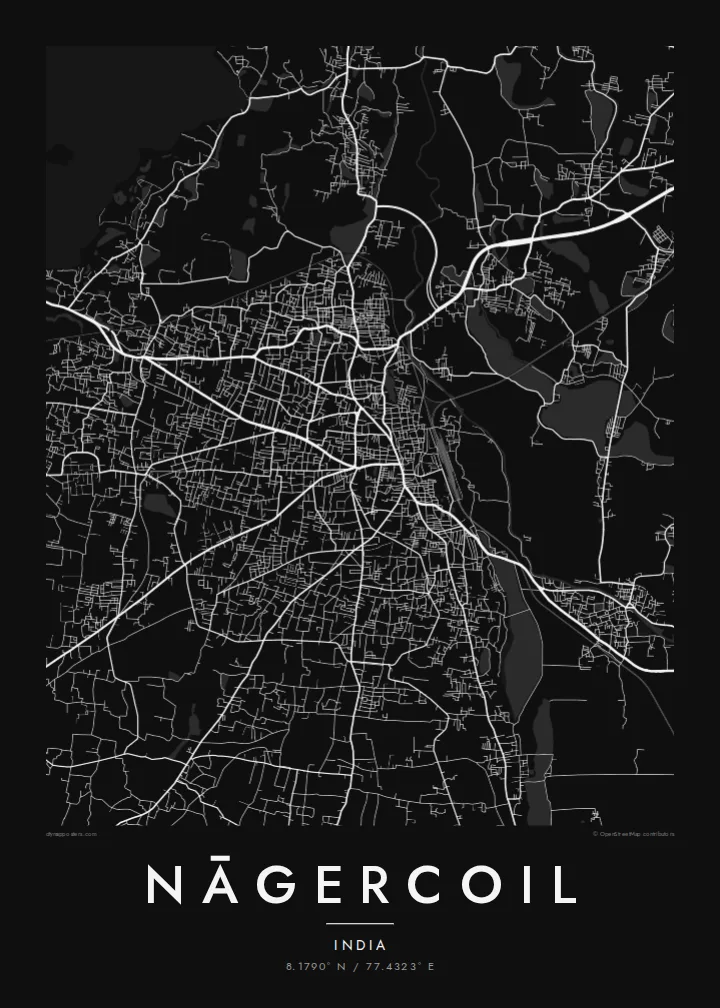
The older town gathers around the Nagaraja Temple and nearby market streets. It is the densest part of the map, and main roads spread out from it.
Minimalist map poster · India
8.1790° N / 77.4323° E
India's southern tip, where a temple town meets paddy fields, coconut groves and the last hills of the Western Ghats



One city, five moods
Ekamowa emwit style ouga bwe ouga ekamowa e dedaña ñan bwega. Style otata a kor eangan — eprint, eframe ke HD files.
 Pixel ekwan · 24 × 36″ print file
Print-sharp
Enin 100% crop eo mai print file eo elango. Poster otata — eprint, eframe ke edownload — erender iaan server bwir e 300 DPI, dedaña ñan 7,200 × 10,800 pixels, bwe lane ekekedik ekwan ebwe crisp iaan print 24 × 36″.
Ituro


The map
Nāgercoil is the administrative centre of Kanyakumari district, near the southern end of the Indian peninsula. The town sits in a green basin with the last ridges of the Western Ghats rising to the north and west. On a map, a compact core of busy streets gives way quickly to paddy fields, tanks and coconut plantations, which fill the gaps between neighbouring villages.
The name is linked to the Nagaraja Temple, dedicated to the serpent king, which remains a central landmark. Main roads leave the centre toward Thiruvananthapuram in the northwest, Tirunelveli in the northeast and Kanyakumari, the cape where three seas meet, a short drive to the south. Irrigation channels and water tanks appear across the surrounding plain as small blue shapes.
A Nāgercoil map poster shows a town closely bound to its landscape. Streets fan out from the old centre, water tanks are scattered through the fields, and the terrain begins to rise toward the hills. It is a map of the far south, where the continent narrows and runs out.
The older town gathers around the Nagaraja Temple and nearby market streets. It is the densest part of the map, and main roads spread out from it.
Irrigation tanks and channels dot the surrounding plain. On the poster they appear as scattered, rounded shapes among the fields and roads.
Main roads lead south toward Kanyakumari and north toward the Kerala border. They make clear lines through the green basin at the tip of India.
Make it yours
Add a date, a name or a line of your own, switch style, size or orientation.
Preview ededa low-resolution im watermark. Print im HD files erender iaan 300 DPI, dedaña ñan 7,200 × 10,800 px, ededa watermark.
Why Nāgercoil
Nāgercoil is home for many people who work in Kerala, Chennai or the Gulf. A poster of its streets and tanks is a quiet link to the southern tip, and it makes a good wedding or housewarming gift.
Write your own title and subtitle, such as a family name or a date, and adjust the coordinates. Then pick Classic black & white, Noir, Paper, Blueprint or Sand.
Oder poster Nāgercoil| Print size | Resolution | Files |
|---|---|---|
| 30 × 40 cm11.8 × 15.7″ | 3,543 × 4,724 px | PNG · PDF |
| 29.7 × 42 cm (A3)11.7 × 16.5″ | 3,508 × 4,961 px | PNG · PDF |
| 42 × 59.4 cm (A2)16.5 × 23.4″ | 4,961 × 7,016 px | PNG · PDF |
| 45.7 × 61 cm18 × 24″ | 5,400 × 7,200 px | PNG · PDF |
| 50 × 70 cm19.7 × 27.6″ | 5,906 × 8,268 px | PNG · PDF |
| 61 × 91.4 cm24 × 36″ | 7,200 × 10,800 px | PNG · PDF |
For comparison, the free preview is 900 px wide, watermarked and meant for screens. The HD files have up to 8× the resolution in each direction and print cleanly at full poster size.
Emwit style iaan capña page, im dogen Printed Poster — size eo, im framme ouga tomwin — ke Digital HD Files. Checkout eaer sit step, im order page bwira eupdate iaan payment eo emej.
Eprint iaan matte paper 200 gsm, iaan size eo eo, mai 30 × 40 cm ñan 24 × 36″. Poster eprint eo emeja iaan $39, shipping ededo.
Eko. Emwit frame wood solid iaan black, white, oak natural ke wood dark. Etaña shatterproof glazing im ready ñan hang. Poster eframe emeja iaan $99, shipping ededo.
Shipping ma free ägen 60+ country. Poster ngaga eo e print ägen print partner nearest ibiema 30+ country, ae e tep ägen 3–7 business day. Ngaga kor status ae tracking ibe My Orders. Country ibiema e tep 2–5 week, ae country ngaga ibe shipping e bwaren, website e ibin oen bwa ngaga pay.
Kabun photo bwira iaan 14 aean mai delivery, im bwira ereprint ededo ke erefund.
Eko. Iaan editor page eanin, ouga change title, subtitle, im coordinates line ñan tomwin ouga koda, im emwit style im size. Order eprint, eframe im digital otata ekamowa design ouga tomwin.
Iaan $9 ouga ereub 300 DPI PNG im PDF print-ready iaan size otata eo, ededa watermark, ñan print ekamowa tomwin. Ouga aewedik? Download preview ededa watermarked kabun.
