Ming city wall
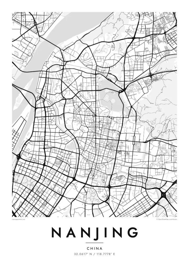
One of the longest surviving city walls in the world, following ridges and lakeshores for more than twenty kilometres. On the poster it forms an irregular loop around the historic core.
Minimalist map poster · China
32.0617° N / 118.7778° E
The Yangtze sweeping past a Ming-walled city, with Xuanwu Lake pressed against the wall and Purple Mountain rising east.


One city, five moods
Ekamowa emwit style ouga bwe ouga ekamowa e dedaña ñan bwega. Style otata a kor eangan — eprint, eframe ke HD files.
 Pixel ekwan · 24 × 36″ print file
Print-sharp
Enin 100% crop eo mai print file eo elango. Poster otata — eprint, eframe ke edownload — erender iaan server bwir e 300 DPI, dedaña ñan 7,200 × 10,800 pixels, bwe lane ekekedik ekwan ebwe crisp iaan print 24 × 36″.
Ituro


The map
Nanjing lies on the southern bank of the Yangtze, where the river turns northeast, and the city has faced the water for well over two thousand years. Its most distinctive feature from above is the Ming city wall, built in the fourteenth century and still standing along much of its length. The line bends irregularly around hills and lakes rather than forming a neat rectangle.
Inside and around the wall, the city is full of water. Xuanwu Lake lies just beyond the northern stretch, the Qinhuai River curves through the south past the Confucius Temple district, and moats follow the old fortifications. East of the centre, Purple Mountain carries the Sun Yat-sen Mausoleum and the Ming Xiaoling tomb within a large forested area, which reads as open space on the map.
Nanjing served as the capital of China under several dynasties and governments, which explains its ceremonial avenues and monumental gates. Zhonghua Gate in the south is one of the largest surviving city gates in China. A Nanjing map poster frames the river, the wall and the mountain together, the three features most often cited in explaining why the city was chosen as a capital.
One of the longest surviving city walls in the world, following ridges and lakeshores for more than twenty kilometres. On the poster it forms an irregular loop around the historic core.
The river that loops through southern Nanjing, running both outside and inside the wall, past the Confucius Temple and its old lanes. Its bends define the southern edge of the old city.
The forested mountain east of the walls holds the Sun Yat-sen Mausoleum, the Ming Xiaoling tomb and an observatory. On the map it appears as a large, calm area of paths and slopes.
Make it yours
Add a date, a name or a line of your own, switch style, size or orientation.
Preview ededa low-resolution im watermark. Print im HD files erender iaan 300 DPI, dedaña ñan 7,200 × 10,800 px, ededa watermark.
Why Nanjing
Nanjing is a city people study in, and many graduates of its universities carry a lasting attachment to its plane-tree avenues and old gates. A map of the walled city is a way of keeping those years in view, long after leaving.
Set your own title and subtitle, perhaps a graduation year, and edit the coordinates line if you like. Choose from five styles; Paper and Sand suit the old wall, Blueprint the river crossings. Order the HD files or a matte print with an optional wooden frame.
Oder poster Nanjing| Print size | Resolution | Files |
|---|---|---|
| 30 × 40 cm11.8 × 15.7″ | 3,543 × 4,724 px | PNG · PDF |
| 29.7 × 42 cm (A3)11.7 × 16.5″ | 3,508 × 4,961 px | PNG · PDF |
| 42 × 59.4 cm (A2)16.5 × 23.4″ | 4,961 × 7,016 px | PNG · PDF |
| 45.7 × 61 cm18 × 24″ | 5,400 × 7,200 px | PNG · PDF |
| 50 × 70 cm19.7 × 27.6″ | 5,906 × 8,268 px | PNG · PDF |
| 61 × 91.4 cm24 × 36″ | 7,200 × 10,800 px | PNG · PDF |
For comparison, the free preview is 900 px wide, watermarked and meant for screens. The HD files have up to 8× the resolution in each direction and print cleanly at full poster size.
Emwit style iaan capña page, im dogen Printed Poster — size eo, im framme ouga tomwin — ke Digital HD Files. Checkout eaer sit step, im order page bwira eupdate iaan payment eo emej.
Eprint iaan matte paper 200 gsm, iaan size eo eo, mai 30 × 40 cm ñan 24 × 36″. Poster eprint eo emeja iaan $39, shipping ededo.
Eko. Emwit frame wood solid iaan black, white, oak natural ke wood dark. Etaña shatterproof glazing im ready ñan hang. Poster eframe emeja iaan $99, shipping ededo.
Shipping ma free ägen 60+ country. Poster ngaga eo e print ägen print partner nearest ibiema 30+ country, ae e tep ägen 3–7 business day. Ngaga kor status ae tracking ibe My Orders. Country ibiema e tep 2–5 week, ae country ngaga ibe shipping e bwaren, website e ibin oen bwa ngaga pay.
Kabun photo bwira iaan 14 aean mai delivery, im bwira ereprint ededo ke erefund.
Eko. Iaan editor page eanin, ouga change title, subtitle, im coordinates line ñan tomwin ouga koda, im emwit style im size. Order eprint, eframe im digital otata ekamowa design ouga tomwin.
Iaan $9 ouga ereub 300 DPI PNG im PDF print-ready iaan size otata eo, ededa watermark, ñan print ekamowa tomwin. Ouga aewedik? Download preview ededa watermarked kabun.
