Natori River mouth
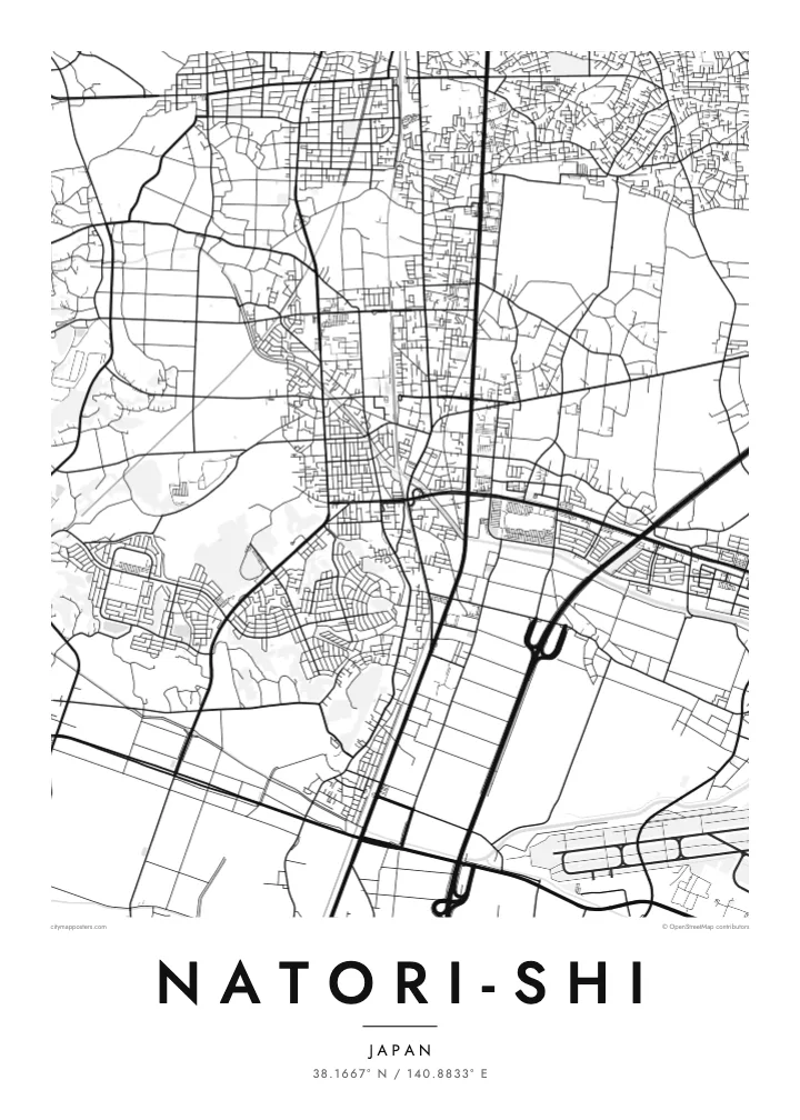
The river reaches the Pacific at Yuriage. Its final bend and the rebuilt harbour district form the most detailed part of the coastline on the map.
Minimalist map poster · Japan
38.1667° N / 140.8833° E
A flat coastal city south of Sendai, stretching from inland neighbourhoods across rice fields to the port of Yuriage on the Pacific.


One city, five moods
Ekamowa emwit style ouga bwe ouga ekamowa e dedaña ñan bwega. Style otata a kor eangan — eprint, eframe ke HD files.
 Pixel ekwan · 24 × 36″ print file
Print-sharp
Enin 100% crop eo mai print file eo elango. Poster otata — eprint, eframe ke edownload — erender iaan server bwir e 300 DPI, dedaña ñan 7,200 × 10,800 pixels, bwe lane ekekedik ekwan ebwe crisp iaan print 24 × 36″.
Ituro


The map
Natori lies directly south of Sendai in Miyagi Prefecture, on the broad coastal plain along Sendai Bay. The Natori River forms much of its boundary with Sendai. On a map the city reads as a band of land stretching from low hills and suburbs in the west, across farmland, to a straight Pacific shoreline in the east.
The coastal district of Yuriage, at the mouth of the river, was devastated by the tsunami of March 2011 and has since been rebuilt on raised ground. Sendai Airport lies at the city's southern edge, shared with neighbouring Iwanuma, its runway a clean straight line near the coast. Rail and road links have made Natori a commuter city for Sendai.
A Natori-shi map poster captures a place defined by its plain: rectangular paddy fields, a river winding to the sea, a straight coastline and a runway. For people with family roots in Yuriage, or memories of the coast before and after 2011, it can be a deeply personal piece to hang at home.
The river reaches the Pacific at Yuriage. Its final bend and the rebuilt harbour district form the most detailed part of the coastline on the map.
The airport sits on the coastal plain at the city's southern edge. Its long runway is a crisp geometric line among the fields.
Between the town centre and the sea, rice fields in regular rectangles cover the land. They give the eastern half of the poster a quiet, even texture.
Make it yours
Add a date, a name or a line of your own, switch style, size or orientation.
Preview ededa low-resolution im watermark. Print im HD files erender iaan 300 DPI, dedaña ñan 7,200 × 10,800 px, ededa watermark.
Why Natori-shi
Natori is home to many who commute to Sendai, and to families who have lived on the coast for generations. A map of the city holds both the newer neighbourhoods and the rebuilt shoreline in one quiet frame.
Choose a title and subtitle, perhaps the name of a district and a date, and edit the coordinates. Five styles are available, from Classic black & white to Sand. Download 300 DPI PNG and PDF files in six sizes for $9.
Oder poster Natori-shi| Print size | Resolution | Files |
|---|---|---|
| 30 × 40 cm11.8 × 15.7″ | 3,543 × 4,724 px | PNG · PDF |
| 29.7 × 42 cm (A3)11.7 × 16.5″ | 3,508 × 4,961 px | PNG · PDF |
| 42 × 59.4 cm (A2)16.5 × 23.4″ | 4,961 × 7,016 px | PNG · PDF |
| 45.7 × 61 cm18 × 24″ | 5,400 × 7,200 px | PNG · PDF |
| 50 × 70 cm19.7 × 27.6″ | 5,906 × 8,268 px | PNG · PDF |
| 61 × 91.4 cm24 × 36″ | 7,200 × 10,800 px | PNG · PDF |
For comparison, the free preview is 900 px wide, watermarked and meant for screens. The HD files have up to 8× the resolution in each direction and print cleanly at full poster size.
Emwit style iaan capña page, im dogen Printed Poster — size eo, im framme ouga tomwin — ke Digital HD Files. Checkout eaer sit step, im order page bwira eupdate iaan payment eo emej.
Eprint iaan matte paper 200 gsm, iaan size eo eo, mai 30 × 40 cm ñan 24 × 36″. Poster eprint eo emeja iaan $39, shipping ededo.
Eko. Emwit frame wood solid iaan black, white, oak natural ke wood dark. Etaña shatterproof glazing im ready ñan hang. Poster eframe emeja iaan $99, shipping ededo.
Shipping ma free ägen 60+ country. Poster ngaga eo e print ägen print partner nearest ibiema 30+ country, ae e tep ägen 3–7 business day. Ngaga kor status ae tracking ibe My Orders. Country ibiema e tep 2–5 week, ae country ngaga ibe shipping e bwaren, website e ibin oen bwa ngaga pay.
Kabun photo bwira iaan 14 aean mai delivery, im bwira ereprint ededo ke erefund.
Eko. Iaan editor page eanin, ouga change title, subtitle, im coordinates line ñan tomwin ouga koda, im emwit style im size. Order eprint, eframe im digital otata ekamowa design ouga tomwin.
Iaan $9 ouga ereub 300 DPI PNG im PDF print-ready iaan size otata eo, ededa watermark, ñan print ekamowa tomwin. Ouga aewedik? Download preview ededa watermarked kabun.
