Wenceslas Square
It appears as a long, wide rectangle rather than a true square, running for roughly 750 metres. The National Museum closes it at the upper end.
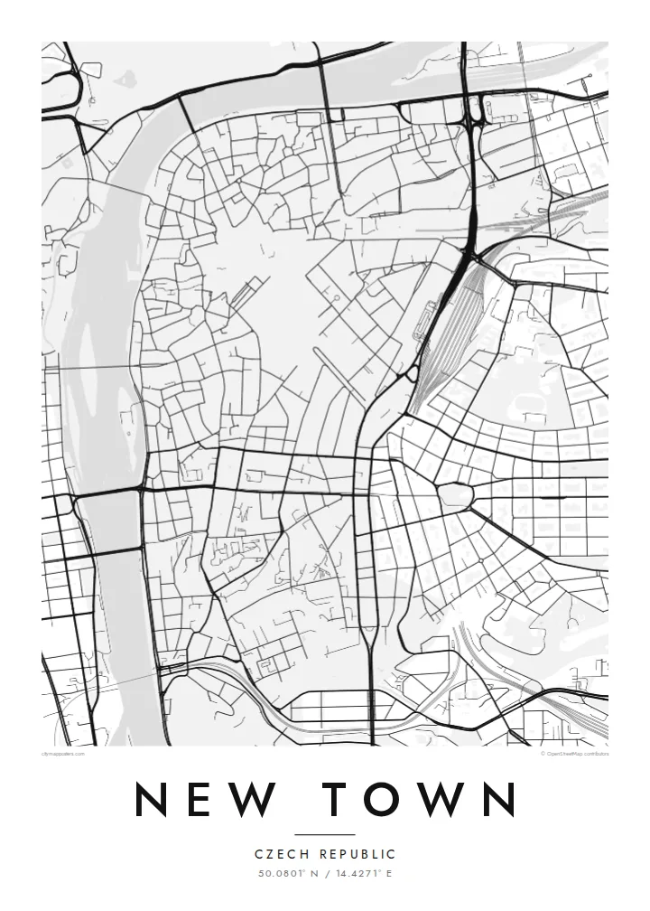
Minimalist map poster · Czechia
50.0801° N / 14.4271° E
Charles IV's planned extension of Prague, laid out in broad squares and long straight streets that run down to the Vltava.


One city, five moods
Ekamowa emwit style ouga bwe ouga ekamowa e dedaña ñan bwega. Style otata a kor eangan — eprint, eframe ke HD files.
 Pixel ekwan · 24 × 36″ print file
Print-sharp
Enin 100% crop eo mai print file eo elango. Poster otata — eprint, eframe ke edownload — erender iaan server bwir e 300 DPI, dedaña ñan 7,200 × 10,800 pixels, bwe lane ekekedik ekwan ebwe crisp iaan print 24 × 36″.
Ituro


The map
New Town, or Nové Město, was founded by Charles IV in 1348 as a deliberate expansion of Prague beyond the older walls. The name has stayed the same for nearly seven centuries, and on a map the district still looks planned. Its wider streets, generous market squares and clear framework stand apart from the tangled lanes of the Old Town to the north.
Two large open spaces anchor the district. Wenceslas Square began as a horse market and is really a long boulevard that climbs gently toward the National Museum. Charles Square, further south, is one of the largest squares in Europe and today holds a park. Between them runs a grid of blocks full of arcades, passages and inner courtyards.
The western edge follows the Vltava embankment, where the Dancing House stands facing the river. A New Town map poster shows the whole sequence within about three square kilometres: the squares, the riverbank, and streets such as Na Příkopě, whose name recalls the old moat that once separated this district from the Old Town.
It appears as a long, wide rectangle rather than a true square, running for roughly 750 metres. The National Museum closes it at the upper end.
This vast rectangle was laid out as the medieval cattle market and is now planted as a park. On the map it is an open block framed by streets, with the New Town Hall on its northern side.
The district's western edge is a continuous riverfront road facing Slavonic Island and the opposite bank, with bridges crossing the water at regular intervals.
Make it yours
Add a date, a name or a line of your own, switch style, size or orientation.
Preview ededa low-resolution im watermark. Print im HD files erender iaan 300 DPI, dedaña ñan 7,200 × 10,800 px, ededa watermark.
Why New Town
New Town is where many people actually lived, studied or worked in Prague, among its squares, tram lines and side streets. A map of the district recalls that everyday city more than the postcard view from the bridge, which makes it a quietly personal choice.
Personalise the title, subtitle and coordinates line with a name, an address or the year you arrived, then pick one of five styles, from Classic black & white to Blueprint or Sand. The $9 digital files come in six sizes without a watermark, and printed posters ship from partners in more than 30 countries.
Oder poster New Town| Print size | Resolution | Files |
|---|---|---|
| 30 × 40 cm11.8 × 15.7″ | 3,543 × 4,724 px | PNG · PDF |
| 29.7 × 42 cm (A3)11.7 × 16.5″ | 3,508 × 4,961 px | PNG · PDF |
| 42 × 59.4 cm (A2)16.5 × 23.4″ | 4,961 × 7,016 px | PNG · PDF |
| 45.7 × 61 cm18 × 24″ | 5,400 × 7,200 px | PNG · PDF |
| 50 × 70 cm19.7 × 27.6″ | 5,906 × 8,268 px | PNG · PDF |
| 61 × 91.4 cm24 × 36″ | 7,200 × 10,800 px | PNG · PDF |
For comparison, the free preview is 900 px wide, watermarked and meant for screens. The HD files have up to 8× the resolution in each direction and print cleanly at full poster size.
Emwit style iaan capña page, im dogen Printed Poster — size eo, im framme ouga tomwin — ke Digital HD Files. Checkout eaer sit step, im order page bwira eupdate iaan payment eo emej.
Eprint iaan matte paper 200 gsm, iaan size eo eo, mai 30 × 40 cm ñan 24 × 36″. Poster eprint eo emeja iaan $39, shipping ededo.
Eko. Emwit frame wood solid iaan black, white, oak natural ke wood dark. Etaña shatterproof glazing im ready ñan hang. Poster eframe emeja iaan $99, shipping ededo.
Shipping ma free ägen 60+ country. Poster ngaga eo e print ägen print partner nearest ibiema 30+ country, ae e tep ägen 3–7 business day. Ngaga kor status ae tracking ibe My Orders. Country ibiema e tep 2–5 week, ae country ngaga ibe shipping e bwaren, website e ibin oen bwa ngaga pay.
Kabun photo bwira iaan 14 aean mai delivery, im bwira ereprint ededo ke erefund.
Eko. Iaan editor page eanin, ouga change title, subtitle, im coordinates line ñan tomwin ouga koda, im emwit style im size. Order eprint, eframe im digital otata ekamowa design ouga tomwin.
Iaan $9 ouga ereub 300 DPI PNG im PDF print-ready iaan size otata eo, ededa watermark, ñan print ekamowa tomwin. Ouga aewedik? Download preview ededa watermarked kabun.
