Lake Biwa shoreline
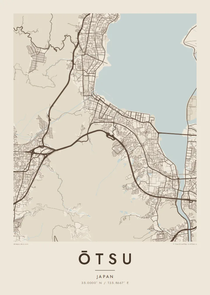
The lake fills a large part of the frame, and the city follows its edge in a long, gently curving strip of streets, promenades and reclaimed waterfront.
Minimalist map poster · Japan
35.0000° N / 135.8667° E
A long lakeside city on the southern tip of Lake Biwa, pressed between the water and the slopes of Mount Hiei


One city, five moods
Ekamowa emwit style ouga bwe ouga ekamowa e dedaña ñan bwega. Style otata a kor eangan — eprint, eframe ke HD files.
 Pixel ekwan · 24 × 36″ print file
Print-sharp
Enin 100% crop eo mai print file eo elango. Poster otata — eprint, eframe ke edownload — erender iaan server bwir e 300 DPI, dedaña ñan 7,200 × 10,800 pixels, bwe lane ekekedik ekwan ebwe crisp iaan print 24 × 36″.
Ituro


The map
Ōtsu, the capital of Shiga Prefecture, stretches along the southwestern shore of Lake Biwa, the largest lake in Japan. The city is long and narrow: a band of streets and rail lines squeezed between the lake and the wooded ridges that separate it from Kyoto. On a map the shoreline and the mountains define almost every neighbourhood.
The city's roots run deep. In the seventh century it briefly served as the imperial capital under Emperor Tenji, and above it, on Mount Hiei, stands Enryaku-ji, the head temple of Tendai Buddhism. Closer to the water are Mii-dera and, to the south, Ishiyama-dera, where Murasaki Shikibu is said to have begun The Tale of Genji.
At the lake's southern end the Seta River flows out beneath the old Seta bridge, and the Lake Biwa Canal leaves the city through tunnels towards Kyoto. An Ōtsu map poster traces these lines of water and movement: the shore, the river, the canal and the roads that have linked the lake to the old capital for centuries.
The lake fills a large part of the frame, and the city follows its edge in a long, gently curving strip of streets, promenades and reclaimed waterfront.
At the southern tip the lake narrows into the Seta River, its only natural outlet, crossed by the long Seta no Karahashi bridge that has stood at this point in various forms for centuries.
Behind the city the ground rises sharply into Mount Hiei and the neighbouring hills, where the street grid gives way to forest and winding temple roads.
Make it yours
Add a date, a name or a line of your own, switch style, size or orientation.
Preview ededa low-resolution im watermark. Print im HD files erender iaan 300 DPI, dedaña ñan 7,200 × 10,800 px, ededa watermark.
Why Ōtsu
Ōtsu appeals to anyone who loves the meeting of water and mountains, and to those who know it from temple visits, lakeside walks or a daily commute to Kyoto. The long shoreline composition works especially well on a tall portrait format.
Personalise the title, subtitle and coordinates, perhaps with a date or a lakeside address, and select one of five styles: Classic black & white, Noir, Paper, Blueprint or Sand. Each style gives the broad shape of the lake a different weight against the streets.
Oder poster Ōtsu| Print size | Resolution | Files |
|---|---|---|
| 30 × 40 cm (11.8 × 15.7″) | 3,543 × 4,724 px | PNG · PDF |
| 29.7 × 42 cm (A3, 11.7 × 16.5″) | 3,508 × 4,961 px | PNG · PDF |
| 42 × 59.4 cm (A2, 16.5 × 23.4″) | 4,961 × 7,016 px | PNG · PDF |
| 45.7 × 61 cm (18 × 24″) | 5,400 × 7,200 px | PNG · PDF |
| 50 × 70 cm (19.7 × 27.6″) | 5,906 × 8,268 px | PNG · PDF |
| 61 × 91.4 cm (24 × 36″) | 7,200 × 10,800 px | PNG · PDF |
For comparison, the free preview is 900 px wide, watermarked and meant for screens. The HD files have up to 8× the resolution in each direction and print cleanly at full poster size.
Emwit style iaan capña page, im dogen Printed Poster — size eo, im framme ouga tomwin — ke Digital HD Files. Checkout eaer sit step, im order page bwira eupdate iaan payment eo emej.
Eprint iaan matte paper 200 gsm, iaan size eo eo, mai 30 × 40 cm ñan 24 × 36″. Poster eprint eo emeja iaan $39, shipping ededo.
Eko. Emwit frame wood solid iaan black, white, oak natural ke wood dark. Etaña shatterproof glazing im ready ñan hang. Poster eframe emeja iaan $99, shipping ededo.
Eaeoen e ngaaba ngeni ouwa age ngaabe. Ngaeo poster e ibiyaneo ibon e print partner eg ibom ngaen ingi ngae 30+ eben, e naeo e yan ngaae e 3–7 aon wan ewa. Kom ngaa e eain ingi tracking ibon My Orders. Tauweo ebe 2–5 wik, ingi ibon ngaen ibun e ngaeo ngaeigie, e saet e sooe nuwe kom e pae.
Kabun photo bwira iaan 14 aean mai delivery, im bwira ereprint ededo ke erefund.
Eko. Iaan editor page eanin, ouga change title, subtitle, im coordinates line ñan tomwin ouga koda, im emwit style im size. Order eprint, eframe im digital otata ekamowa design ouga tomwin.
Iaan $9 ouga ereub 300 DPI PNG im PDF print-ready iaan size otata eo, ededa watermark, ñan print ekamowa tomwin. Ouga aewedik? Download preview ededa watermarked kabun.
