Backwater channels
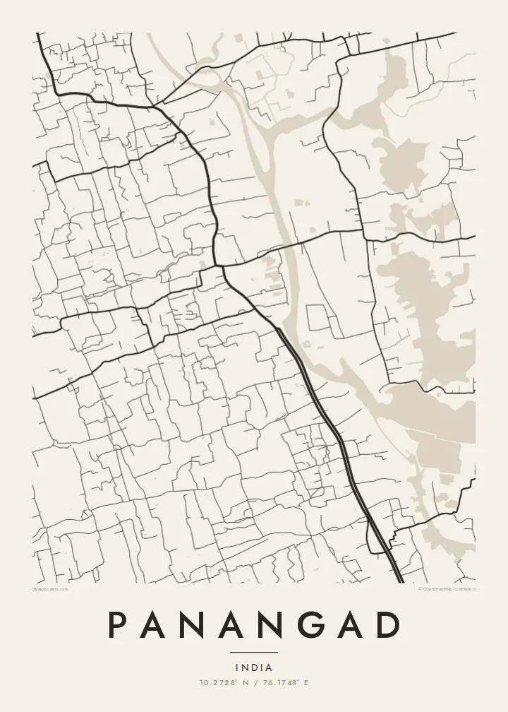
Lagoons and canals divide the land into thin, irregular pieces. On the poster, the water takes up much of the frame and gives the map an almost abstract quality.
Minimalist map poster · India
10.2728° N / 76.1748° E
A backwater suburb south of Kochi, where narrow land strips, canals and bridges weave between open water




One city, five moods
Ekamowa emwit style ouga bwe ouga ekamowa e dedaña ñan bwega. Style otata a kor eangan — eprint, eframe ke HD files.
 Pixel ekwan · 24 × 36″ print file
Print-sharp
Enin 100% crop eo mai print file eo elango. Poster otata — eprint, eframe ke edownload — erender iaan server bwir e 300 DPI, dedaña ñan 7,200 × 10,800 pixels, bwe lane ekekedik ekwan ebwe crisp iaan print 24 × 36″.
Ituro


The map
Panangad is a suburban area in Kerala's Ernakulam district, a short distance south of Kochi. It lies within the backwater landscape that surrounds the city. On a map, land and water are closely interlocked. Thin strips of settled ground run between lagoons and canals, and roads reach across the water on causeways and bridges.
The pattern is dense but not gridded. Lanes follow the edges of the land, houses line the water, and coconut groves fill the spaces between them. The national highway passes nearby on its way through the Kochi region and cuts a straighter line through the looser local network. Much of the poster's surface is water, which makes the land feel delicate and carefully drawn.
A Panangad map poster is a portrait of the backwaters as they really look from above: a patchwork of islands and peninsulas. The area is home to the Kerala University of Fisheries and Ocean Studies, a fitting institution for a place where fishing, aquaculture and water shape both the land and daily life.
Lagoons and canals divide the land into thin, irregular pieces. On the poster, the water takes up much of the frame and gives the map an almost abstract quality.
Roads cross the water on narrow causeways and bridges, linking Panangad with neighbouring islands and the Kochi mainland. They appear as fine threads across the open water.
Local streets curve along the shore rather than running in straight lines. The result is a soft, flowing network, typical of Kerala's backwater settlements.
Make it yours
Add a date, a name or a line of your own, switch style, size or orientation.
Preview ededa low-resolution im watermark. Print im HD files erender iaan 300 DPI, dedaña ñan 7,200 × 10,800 px, ededa watermark.
Why Panangad
Anyone who has lived in or around Kochi will recognise this distinctive mix of land and water. The poster works as a reminder of home for Keralites abroad, or as a striking graphic piece for anyone drawn to coastal landscapes.
You can personalise the title, subtitle and coordinates line, for example with a house name or a family date. There are five styles: Classic black & white, Noir, Paper, Blueprint and Sand. Blueprint makes the backwaters stand out.
Oder poster Panangad| Print size | Resolution | Files |
|---|---|---|
| 30 × 40 cm11.8 × 15.7″ | 3,543 × 4,724 px | PNG · PDF |
| 29.7 × 42 cm (A3)11.7 × 16.5″ | 3,508 × 4,961 px | PNG · PDF |
| 42 × 59.4 cm (A2)16.5 × 23.4″ | 4,961 × 7,016 px | PNG · PDF |
| 45.7 × 61 cm18 × 24″ | 5,400 × 7,200 px | PNG · PDF |
| 50 × 70 cm19.7 × 27.6″ | 5,906 × 8,268 px | PNG · PDF |
| 61 × 91.4 cm24 × 36″ | 7,200 × 10,800 px | PNG · PDF |
For comparison, the free preview is 900 px wide, watermarked and meant for screens. The HD files have up to 8× the resolution in each direction and print cleanly at full poster size.
Emwit style iaan capña page, im dogen Printed Poster — size eo, im framme ouga tomwin — ke Digital HD Files. Checkout eaer sit step, im order page bwira eupdate iaan payment eo emej.
Eprint iaan matte paper 200 gsm, iaan size eo eo, mai 30 × 40 cm ñan 24 × 36″. Poster eprint eo emeja iaan $39, shipping ededo.
Eko. Emwit frame wood solid iaan black, white, oak natural ke wood dark. Etaña shatterproof glazing im ready ñan hang. Poster eframe emeja iaan $99, shipping ededo.
Shipping ma free ägen 60+ country. Poster ngaga eo e print ägen print partner nearest ibiema 30+ country, ae e tep ägen 3–7 business day. Ngaga kor status ae tracking ibe My Orders. Country ibiema e tep 2–5 week, ae country ngaga ibe shipping e bwaren, website e ibin oen bwa ngaga pay.
Kabun photo bwira iaan 14 aean mai delivery, im bwira ereprint ededo ke erefund.
Eko. Iaan editor page eanin, ouga change title, subtitle, im coordinates line ñan tomwin ouga koda, im emwit style im size. Order eprint, eframe im digital otata ekamowa design ouga tomwin.
Iaan $9 ouga ereub 300 DPI PNG im PDF print-ready iaan size otata eo, ededa watermark, ñan print ekamowa tomwin. Ouga aewedik? Download preview ededa watermarked kabun.
