Penn's five squares
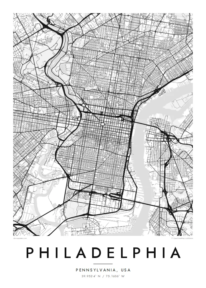
City Hall at the centre and four squares placed symmetrically around it are still visible as open spaces in the grid, a direct trace of the 1682 plan.
Minimalist map poster · United States
39.9524° N / 75.1636° W
William Penn's orderly grid between two rivers, anchored by City Hall and cut by a single diagonal parkway.


One city, five moods
Ekamowa emwit style ouga bwe ouga ekamowa e dedaña ñan bwega. Style otata a kor eangan — eprint, eframe ke HD files.
 Pixel ekwan · 24 × 36″ print file
Print-sharp
Enin 100% crop eo mai print file eo elango. Poster otata — eprint, eframe ke edownload — erender iaan server bwir e 300 DPI, dedaña ñan 7,200 × 10,800 pixels, bwe lane ekekedik ekwan ebwe crisp iaan print 24 × 36″.
Ituro


The map
Philadelphia began as one of the first planned cities in America. In 1682 William Penn and his surveyor Thomas Holme laid out a rectangular grid stretching between the Delaware River on the east and the Schuylkill on the west, with five public squares placed at regular points. That plan still governs Center City, and it is easy to trace on a map today.
Broad Street and Market Street cross at the central square, where City Hall now stands, and four smaller squares, Rittenhouse, Washington, Logan and Franklin, sit in each quadrant. Near the Delaware, Independence Hall marks where the Declaration of Independence and the Constitution were debated and signed. Beyond the original grid, later neighbourhoods tilt and bend to follow old roads and the rivers.
The Benjamin Franklin Parkway breaks the pattern with a deliberate diagonal from City Hall to the Philadelphia Museum of Art, beyond which Fairmount Park follows the Schuylkill and the Wissahickon Creek for miles. A Philadelphia map poster frames all of this: the strict grid, the two rivers and the green valleys winding out toward the northwest.
City Hall at the centre and four squares placed symmetrically around it are still visible as open spaces in the grid, a direct trace of the 1682 plan.
The only major diagonal in Center City runs northwest from City Hall to the art museum, a wide boulevard modelled on Parisian avenues.
One of the largest urban park systems in the country follows the Schuylkill and Wissahickon Creek, drawing long green corridors through the northwestern neighbourhoods.
Make it yours
Add a date, a name or a line of your own, switch style, size or orientation.
Preview ededa low-resolution im watermark. Print im HD files erender iaan 300 DPI, dedaña ñan 7,200 × 10,800 px, ededa watermark.
Why Philadelphia
Philadelphians tend to identify strongly with their neighbourhood, whether that is Fishtown, South Philly, Germantown or Rittenhouse. A map of the city lets you show the whole grid while pointing to one corner of it, a first apartment, a rowhouse or the place you met someone.
Personalise the title, the subtitle and the coordinates line with a street, a name or a date. Choose Classic black & white, Noir, Paper, Blueprint or Sand. Printed posters ship from partners in more than 30 countries, with an optional wooden frame.
Oder poster Philadelphia| Print size | Resolution | Files |
|---|---|---|
| 30 × 40 cm11.8 × 15.7″ | 3,543 × 4,724 px | PNG · PDF |
| 29.7 × 42 cm (A3)11.7 × 16.5″ | 3,508 × 4,961 px | PNG · PDF |
| 42 × 59.4 cm (A2)16.5 × 23.4″ | 4,961 × 7,016 px | PNG · PDF |
| 45.7 × 61 cm18 × 24″ | 5,400 × 7,200 px | PNG · PDF |
| 50 × 70 cm19.7 × 27.6″ | 5,906 × 8,268 px | PNG · PDF |
| 61 × 91.4 cm24 × 36″ | 7,200 × 10,800 px | PNG · PDF |
For comparison, the free preview is 900 px wide, watermarked and meant for screens. The HD files have up to 8× the resolution in each direction and print cleanly at full poster size.
Emwit style iaan capña page, im dogen Printed Poster — size eo, im framme ouga tomwin — ke Digital HD Files. Checkout eaer sit step, im order page bwira eupdate iaan payment eo emej.
Eprint iaan matte paper 200 gsm, iaan size eo eo, mai 30 × 40 cm ñan 24 × 36″. Poster eprint eo emeja iaan $39, shipping ededo.
Eko. Emwit frame wood solid iaan black, white, oak natural ke wood dark. Etaña shatterproof glazing im ready ñan hang. Poster eframe emeja iaan $99, shipping ededo.
Shipping ma free ägen 60+ country. Poster ngaga eo e print ägen print partner nearest ibiema 30+ country, ae e tep ägen 3–7 business day. Ngaga kor status ae tracking ibe My Orders. Country ibiema e tep 2–5 week, ae country ngaga ibe shipping e bwaren, website e ibin oen bwa ngaga pay.
Kabun photo bwira iaan 14 aean mai delivery, im bwira ereprint ededo ke erefund.
Eko. Iaan editor page eanin, ouga change title, subtitle, im coordinates line ñan tomwin ouga koda, im emwit style im size. Order eprint, eframe im digital otata ekamowa design ouga tomwin.
Iaan $9 ouga ereub 300 DPI PNG im PDF print-ready iaan size otata eo, ededa watermark, ñan print ekamowa tomwin. Ouga aewedik? Download preview ededa watermarked kabun.
