Atlantic port
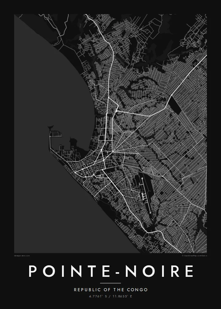
Breakwaters and quays extend into the sea beside the city centre, forming the sharpest geometric shapes on the map and marking the country's main gateway for shipping.
Minimalist map poster · Congo - Brazzaville
4.7761° S / 11.8635° E
An Atlantic port city on a flat coastal plain, where Congo's railway from the interior meets the sea.



One city, five moods
Ekamowa emwit style ouga bwe ouga ekamowa e dedaña ñan bwega. Style otata a kor eangan — eprint, eframe ke HD files.
 Pixel ekwan · 24 × 36″ print file
Print-sharp
Enin 100% crop eo mai print file eo elango. Poster otata — eprint, eframe ke edownload — erender iaan server bwir e 300 DPI, dedaña ñan 7,200 × 10,800 pixels, bwe lane ekekedik ekwan ebwe crisp iaan print 24 × 36″.
Ituro


The map
Pointe-Noire is the main seaport of the Republic of the Congo and the country's economic centre, built on a flat coastal plain beside the Atlantic. Its name comes from a dark rocky point that Portuguese sailors noted along the shore. On a map the coastline gives a strong western edge, with the port's breakwaters and quays reaching into the sea near the centre.
The city is the terminus of the Congo-Ocean Railway, built in the 1920s and 1930s to link the coast with Brazzaville, and its railway station remains a well-known landmark. Offshore oil made Pointe-Noire the base of the country's energy industry, and the port handles much of the national trade. Residential districts spread inland in a wide, fairly regular pattern.
A Pointe-Noire map poster frames the city between ocean and plain: the port and beaches along the shore, the straight roads of the older centre and the broad neighbourhoods behind them. It is a clear, legible plan, and the Atlantic coastline stretching away in both directions gives the composition a calm, steady balance.
Breakwaters and quays extend into the sea beside the city centre, forming the sharpest geometric shapes on the map and marking the country's main gateway for shipping.
The Congo-Ocean Railway ends in the heart of the city, and its line heading inland provides a strong route across the map toward Brazzaville, far to the east.
Long sandy beaches follow the shore on either side of the port, a soft edge between the city streets and the open ocean that runs the length of the composition.
Make it yours
Add a date, a name or a line of your own, switch style, size or orientation.
Preview ededa low-resolution im watermark. Print im HD files erender iaan 300 DPI, dedaña ñan 7,200 × 10,800 px, ededa watermark.
Why Pointe-Noire
Pointe-Noire is home to many families, to port and oil workers, and to people who spent years in the city before moving on. A map of its coast and streets is a personal reminder of that time and a good fit for an office or a home.
The title, subtitle and coordinates line can be personalised, and you can choose from five styles: Classic black & white, Noir, Paper, Blueprint and Sand. HD files without a watermark are $9, and printed posters ship from partners in more than 30 countries.
Oder poster Pointe-Noire| Print size | Resolution | Files |
|---|---|---|
| 30 × 40 cm11.8 × 15.7″ | 3,543 × 4,724 px | PNG · PDF |
| 29.7 × 42 cm (A3)11.7 × 16.5″ | 3,508 × 4,961 px | PNG · PDF |
| 42 × 59.4 cm (A2)16.5 × 23.4″ | 4,961 × 7,016 px | PNG · PDF |
| 45.7 × 61 cm18 × 24″ | 5,400 × 7,200 px | PNG · PDF |
| 50 × 70 cm19.7 × 27.6″ | 5,906 × 8,268 px | PNG · PDF |
| 61 × 91.4 cm24 × 36″ | 7,200 × 10,800 px | PNG · PDF |
For comparison, the free preview is 900 px wide, watermarked and meant for screens. The HD files have up to 8× the resolution in each direction and print cleanly at full poster size.
Emwit style iaan capña page, im dogen Printed Poster — size eo, im framme ouga tomwin — ke Digital HD Files. Checkout eaer sit step, im order page bwira eupdate iaan payment eo emej.
Eprint iaan matte paper 200 gsm, iaan size eo eo, mai 30 × 40 cm ñan 24 × 36″. Poster eprint eo emeja iaan $39, shipping ededo.
Eko. Emwit frame wood solid iaan black, white, oak natural ke wood dark. Etaña shatterproof glazing im ready ñan hang. Poster eframe emeja iaan $99, shipping ededo.
Shipping ma free ägen 60+ country. Poster ngaga eo e print ägen print partner nearest ibiema 30+ country, ae e tep ägen 3–7 business day. Ngaga kor status ae tracking ibe My Orders. Country ibiema e tep 2–5 week, ae country ngaga ibe shipping e bwaren, website e ibin oen bwa ngaga pay.
Kabun photo bwira iaan 14 aean mai delivery, im bwira ereprint ededo ke erefund.
Eko. Iaan editor page eanin, ouga change title, subtitle, im coordinates line ñan tomwin ouga koda, im emwit style im size. Order eprint, eframe im digital otata ekamowa design ouga tomwin.
Iaan $9 ouga ereub 300 DPI PNG im PDF print-ready iaan size otata eo, ededa watermark, ñan print ekamowa tomwin. Ouga aewedik? Download preview ededa watermarked kabun.
