Ribble riverside
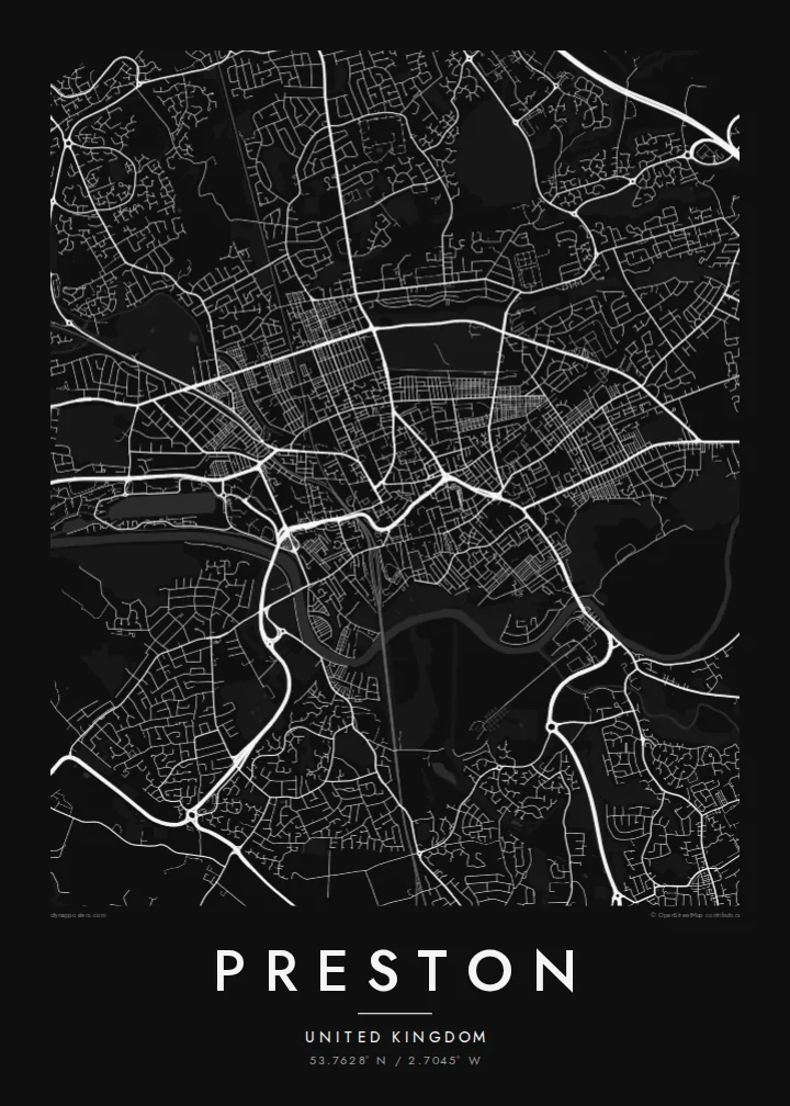
The River Ribble curves along the southern edge, with Avenham and Miller Parks sloping down to meet it, forming a green band beneath the dense centre.
Minimalist map poster · United Kingdom
53.7628° N / 2.7045° W
A Lancashire city above a curve of the Ribble, with riverside parks below the centre and a marina to the west.



One city, five moods
Ekamowa emwit style ouga bwe ouga ekamowa e dedaña ñan bwega. Style otata a kor eangan — eprint, eframe ke HD files.
 Pixel ekwan · 24 × 36″ print file
Print-sharp
Enin 100% crop eo mai print file eo elango. Poster otata — eprint, eframe ke edownload — erender iaan server bwir e 300 DPI, dedaña ñan 7,200 × 10,800 pixels, bwe lane ekekedik ekwan ebwe crisp iaan print 24 × 36″.
Ituro


The map
Preston stands on rising ground on the north bank of the River Ribble, and the river's broad curve forms the southern edge of the city on the map. The centre is compact, with streets converging on the market area and the Flag Market, while terraced neighbourhoods spread north and east in tight parallel rows typical of a Lancashire mill town.
Below the centre, Avenham and Miller Parks slope down to the riverbank in green terraces, and to the west the former dock has become a marina off the Ribble. Preston gained city status in 2002, is home to the University of Central Lancashire, and holds the Preston Guild once every twenty years, a tradition reaching back to the Middle Ages.
The M6 skirts the city to the east; its Preston bypass section, opened in 1958, was the first stretch of motorway in Britain. On a Preston map poster, that motorway, the rail lines and the Lancaster Canal add long lines through the grid, while the river and parks give the composition a soft, open base.
The River Ribble curves along the southern edge, with Avenham and Miller Parks sloping down to meet it, forming a green band beneath the dense centre.
West of the centre, the rectangular former dock basin connects to the river, an unmistakable geometric shape among the curves of the surrounding streets.
Rows of Victorian terraced houses run in tight parallel lines north and east of the centre, giving the map its fine, even texture.
Make it yours
Add a date, a name or a line of your own, switch style, size or orientation.
Preview ededa low-resolution im watermark. Print im HD files erender iaan 300 DPI, dedaña ñan 7,200 × 10,800 px, ededa watermark.
Why Preston
Preston is where many people studied, started work or grew up, and a map poster keeps the shape of those streets close. It is a considered piece for a living room or office, especially for anyone who knows the walk down through the parks to the river.
Personalise the title, subtitle and coordinates, perhaps with a Guild year or a graduation date, and choose from Classic black & white, Noir, Paper, Blueprint or Sand. Digital files are $9 with six sizes included, and printed posters come on matte paper, framed if you like.
Oder poster Preston| Print size | Resolution | Files |
|---|---|---|
| 30 × 40 cm11.8 × 15.7″ | 3,543 × 4,724 px | PNG · PDF |
| 29.7 × 42 cm (A3)11.7 × 16.5″ | 3,508 × 4,961 px | PNG · PDF |
| 42 × 59.4 cm (A2)16.5 × 23.4″ | 4,961 × 7,016 px | PNG · PDF |
| 45.7 × 61 cm18 × 24″ | 5,400 × 7,200 px | PNG · PDF |
| 50 × 70 cm19.7 × 27.6″ | 5,906 × 8,268 px | PNG · PDF |
| 61 × 91.4 cm24 × 36″ | 7,200 × 10,800 px | PNG · PDF |
For comparison, the free preview is 900 px wide, watermarked and meant for screens. The HD files have up to 8× the resolution in each direction and print cleanly at full poster size.
Emwit style iaan capña page, im dogen Printed Poster — size eo, im framme ouga tomwin — ke Digital HD Files. Checkout eaer sit step, im order page bwira eupdate iaan payment eo emej.
Eprint iaan matte paper 200 gsm, iaan size eo eo, mai 30 × 40 cm ñan 24 × 36″. Poster eprint eo emeja iaan $39, shipping ededo.
Eko. Emwit frame wood solid iaan black, white, oak natural ke wood dark. Etaña shatterproof glazing im ready ñan hang. Poster eframe emeja iaan $99, shipping ededo.
Shipping ma free ägen 60+ country. Poster ngaga eo e print ägen print partner nearest ibiema 30+ country, ae e tep ägen 3–7 business day. Ngaga kor status ae tracking ibe My Orders. Country ibiema e tep 2–5 week, ae country ngaga ibe shipping e bwaren, website e ibin oen bwa ngaga pay.
Kabun photo bwira iaan 14 aean mai delivery, im bwira ereprint ededo ke erefund.
Eko. Iaan editor page eanin, ouga change title, subtitle, im coordinates line ñan tomwin ouga koda, im emwit style im size. Order eprint, eframe im digital otata ekamowa design ouga tomwin.
Iaan $9 ouga ereub 300 DPI PNG im PDF print-ready iaan size otata eo, ededa watermark, ñan print ekamowa tomwin. Ouga aewedik? Download preview ededa watermarked kabun.
