Lagoons and bays
Shallow bays and enclosed lagoons break the coastline in many places. They create a sequence of curved inlets that gives the island a detailed, irregular edge.
Minimalist map poster · Indonesia
10.6870° S / 123.1155° E
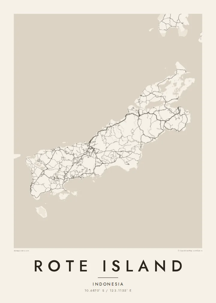
A long, low island just southwest of Timor, its coast scalloped by bays and fringed with lagoons and small islets.




One city, five moods
Ekamowa emwit style ouga bwe ouga ekamowa e dedaña ñan bwega. Style otata a kor eangan — eprint, eframe ke HD files.
 Pixel ekwan · 24 × 36″ print file
Print-sharp
Enin 100% crop eo mai print file eo elango. Poster otata — eprint, eframe ke edownload — erender iaan server bwir e 300 DPI, dedaña ñan 7,200 × 10,800 pixels, bwe lane ekekedik ekwan ebwe crisp iaan print 24 × 36″.
Ituro


The map
Rote, also written Roti, lies off the southwestern tip of Timor in East Nusa Tenggara, near the southern edge of the Indonesian archipelago. It is long and fairly low, stretched roughly from northeast to southwest, with a coastline broken by shallow bays, lagoons and reefs. Smaller islands are scattered around it, especially off the southwestern end.
Much of the island is dry savanna, and the lontar palm has long been central to local life. Its sap is tapped for sugar and drink, and its leaves are used for weaving. The island is also associated with the sasando, a stringed instrument with a resonator made from a lontar leaf. On the southwest coast, Nemberala has become known for its surf.
A Rote Island map poster follows the island's long axis, with a road network that links villages across the dry interior and down to the coast. The main town, Ba'a, sits on the northern side facing Timor, while the bays and lagoons of the southern and western shores give the outline a rich, uneven texture.
Shallow bays and enclosed lagoons break the coastline in many places. They create a sequence of curved inlets that gives the island a detailed, irregular edge.
The main town lies on the northern side of the island and looks across the sea toward Timor. Its streets form the densest cluster of lines on the map.
Off the southwestern end, a scattering of small islands trails into the sea. They include Ndana, often described as the southernmost island of Indonesia.
Make it yours
Add a date, a name or a line of your own, switch style, size or orientation.
Preview ededa low-resolution im watermark. Print im HD files erender iaan 300 DPI, dedaña ñan 7,200 × 10,800 px, ededa watermark.
Why Rote Island
Rote is remembered by surfers who spent weeks waiting for waves at Nemberala and by families whose roots are in its villages. A map poster draws the whole island, from the road to Ba'a to the islets in the far southwest, and gives those memories a quiet, lasting form.
Choose any wording for the title and subtitle, such as a village, a surf break or a date, and edit the coordinates line to match. Classic black & white, Noir, Paper, Blueprint and Sand are all available. The $9 HD set includes six sizes, and there is a free watermarked preview.
Oder poster Rote Island| Print size | Resolution | Files |
|---|---|---|
| 30 × 40 cm11.8 × 15.7″ | 3,543 × 4,724 px | PNG · PDF |
| 29.7 × 42 cm (A3)11.7 × 16.5″ | 3,508 × 4,961 px | PNG · PDF |
| 42 × 59.4 cm (A2)16.5 × 23.4″ | 4,961 × 7,016 px | PNG · PDF |
| 45.7 × 61 cm18 × 24″ | 5,400 × 7,200 px | PNG · PDF |
| 50 × 70 cm19.7 × 27.6″ | 5,906 × 8,268 px | PNG · PDF |
| 61 × 91.4 cm24 × 36″ | 7,200 × 10,800 px | PNG · PDF |
For comparison, the free preview is 900 px wide, watermarked and meant for screens. The HD files have up to 8× the resolution in each direction and print cleanly at full poster size.
Emwit style iaan capña page, im dogen Printed Poster — size eo, im framme ouga tomwin — ke Digital HD Files. Checkout eaer sit step, im order page bwira eupdate iaan payment eo emej.
Eprint iaan matte paper 200 gsm, iaan size eo eo, mai 30 × 40 cm ñan 24 × 36″. Poster eprint eo emeja iaan $39, shipping ededo.
Eko. Emwit frame wood solid iaan black, white, oak natural ke wood dark. Etaña shatterproof glazing im ready ñan hang. Poster eframe emeja iaan $99, shipping ededo.
Shipping ma free ägen 60+ country. Poster ngaga eo e print ägen print partner nearest ibiema 30+ country, ae e tep ägen 3–7 business day. Ngaga kor status ae tracking ibe My Orders. Country ibiema e tep 2–5 week, ae country ngaga ibe shipping e bwaren, website e ibin oen bwa ngaga pay.
Kabun photo bwira iaan 14 aean mai delivery, im bwira ereprint ededo ke erefund.
Eko. Iaan editor page eanin, ouga change title, subtitle, im coordinates line ñan tomwin ouga koda, im emwit style im size. Order eprint, eframe im digital otata ekamowa design ouga tomwin.
Iaan $9 ouga ereub 300 DPI PNG im PDF print-ready iaan size otata eo, ededa watermark, ñan print ekamowa tomwin. Ouga aewedik? Download preview ededa watermarked kabun.
