Two coastlines
Mikawa Bay forms a sheltered, irregular shore to the north, while the Pacific side runs almost straight to the south, giving the poster two very different edges.
Minimalist map poster · Japan
34.6680° N / 137.2674° E
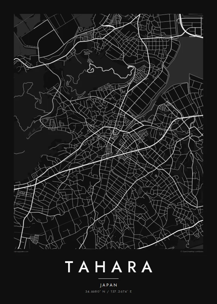
A city stretched along the Atsumi Peninsula, with Mikawa Bay on one side, the Pacific on the other and fields between.



One city, five moods
Ekamowa emwit style ouga bwe ouga ekamowa e dedaña ñan bwega. Style otata a kor eangan — eprint, eframe ke HD files.
 Pixel ekwan · 24 × 36″ print file
Print-sharp
Enin 100% crop eo mai print file eo elango. Poster otata — eprint, eframe ke edownload — erender iaan server bwir e 300 DPI, dedaña ñan 7,200 × 10,800 pixels, bwe lane ekekedik ekwan ebwe crisp iaan print 24 × 36″.
Ituro


The map
Tahara occupies most of the Atsumi Peninsula in southern Aichi Prefecture, a long finger of land that reaches west toward the mouth of Ise Bay. On a map, the city is defined by water: the calm, indented shore of Mikawa Bay along the north, and the straight, exposed Pacific coast along the south, with Cape Irago at the tip.
Between the two coasts, the land is largely agricultural, and Tahara ranks among the most productive farming municipalities in Japan. It is especially known for chrysanthemums grown in greenhouses under electric light, which glow across the fields at night. On the bay side, reclaimed land hosts a large Toyota factory, whose rectangular blocks stand out clearly from above.
A Tahara map poster captures a place with an unusually clear silhouette. The narrow peninsula, the two contrasting coastlines, the town centre near the bay and the regular pattern of fields and greenhouse roads make a composition that is both geographic and graphic, with a strong sense of direction from east to west.
Mikawa Bay forms a sheltered, irregular shore to the north, while the Pacific side runs almost straight to the south, giving the poster two very different edges.
At the western tip of the peninsula, the land narrows to a point facing the entrance to Ise Bay, a natural focal point at the end of the composition.
Along the bay, large geometric blocks of reclaimed land hold port and factory sites, including a major Toyota plant, contrasting with the finer agricultural pattern inland.
Make it yours
Add a date, a name or a line of your own, switch style, size or orientation.
Preview ededa low-resolution im watermark. Print im HD files erender iaan 300 DPI, dedaña ñan 7,200 × 10,800 px, ededa watermark.
Why Tahara
Tahara means something specific to the people who live and work on the peninsula, and to visitors who have driven out to Cape Irago or seen the chrysanthemum greenhouses lit at night. Its long, recognisable shape works especially well in the larger print formats.
Personalise the title, subtitle and coordinates with a name, a date or a place on the peninsula. Five styles are available, Classic black & white, Noir, Paper, Blueprint and Sand, as 300 DPI PNG and PDF files or as a printed poster.
Oder poster Tahara| Print size | Resolution | Files |
|---|---|---|
| 30 × 40 cm11.8 × 15.7″ | 3,543 × 4,724 px | PNG · PDF |
| 29.7 × 42 cm (A3)11.7 × 16.5″ | 3,508 × 4,961 px | PNG · PDF |
| 42 × 59.4 cm (A2)16.5 × 23.4″ | 4,961 × 7,016 px | PNG · PDF |
| 45.7 × 61 cm18 × 24″ | 5,400 × 7,200 px | PNG · PDF |
| 50 × 70 cm19.7 × 27.6″ | 5,906 × 8,268 px | PNG · PDF |
| 61 × 91.4 cm24 × 36″ | 7,200 × 10,800 px | PNG · PDF |
For comparison, the free preview is 900 px wide, watermarked and meant for screens. The HD files have up to 8× the resolution in each direction and print cleanly at full poster size.
Emwit style iaan capña page, im dogen Printed Poster — size eo, im framme ouga tomwin — ke Digital HD Files. Checkout eaer sit step, im order page bwira eupdate iaan payment eo emej.
Eprint iaan matte paper 200 gsm, iaan size eo eo, mai 30 × 40 cm ñan 24 × 36″. Poster eprint eo emeja iaan $39, shipping ededo.
Eko. Emwit frame wood solid iaan black, white, oak natural ke wood dark. Etaña shatterproof glazing im ready ñan hang. Poster eframe emeja iaan $99, shipping ededo.
Shipping ma free ägen 60+ country. Poster ngaga eo e print ägen print partner nearest ibiema 30+ country, ae e tep ägen 3–7 business day. Ngaga kor status ae tracking ibe My Orders. Country ibiema e tep 2–5 week, ae country ngaga ibe shipping e bwaren, website e ibin oen bwa ngaga pay.
Kabun photo bwira iaan 14 aean mai delivery, im bwira ereprint ededo ke erefund.
Eko. Iaan editor page eanin, ouga change title, subtitle, im coordinates line ñan tomwin ouga koda, im emwit style im size. Order eprint, eframe im digital otata ekamowa design ouga tomwin.
Iaan $9 ouga ereub 300 DPI PNG im PDF print-ready iaan size otata eo, ededa watermark, ñan print ekamowa tomwin. Ouga aewedik? Download preview ededa watermarked kabun.
