Valley alignment
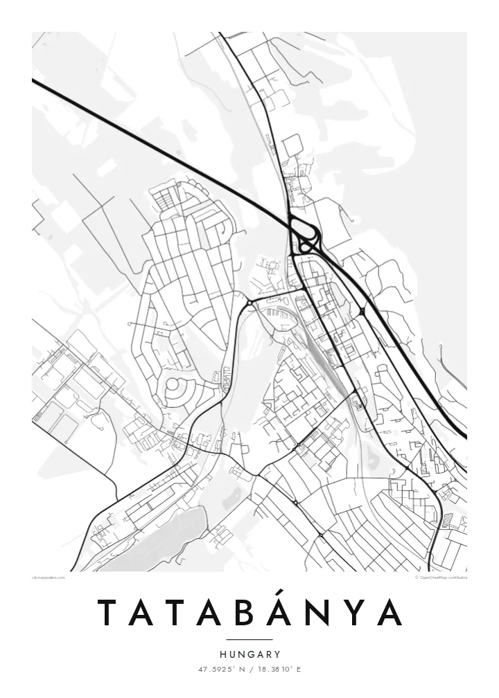
The city stretches along a valley corridor, so its districts, main roads and the railway run roughly in parallel, giving the map a strong linear direction.
Minimalist map poster · Hungary
47.5925° N / 18.3810° E
A former mining city stretched along a valley between wooded hills, watched over by a bronze Turul on the clifftop.


One city, five moods
Ekamowa emwit style ouga bwe ouga ekamowa e dedaña ñan bwega. Style otata a kor eangan — eprint, eframe ke HD files.
 Pixel ekwan · 24 × 36″ print file
Print-sharp
Enin 100% crop eo mai print file eo elango. Poster otata — eprint, eframe ke edownload — erender iaan server bwir e 300 DPI, dedaña ñan 7,200 × 10,800 pixels, bwe lane ekekedik ekwan ebwe crisp iaan print 24 × 36″.
Ituro


The map
Tatabánya is the seat of Komárom-Esztergom County in northern Hungary, and it was formed in 1947 by merging several neighbouring villages and mining settlements. The map still shows that origin: instead of a single historic core, the city is a chain of districts strung along a valley, joined by main roads and the railway between Budapest and Győr.
For much of the twentieth century Tatabánya lived on coal, and the planned housing estates of its mining era are clearly visible from above as tidy blocks and repeated forms. On either side the terrain rises into the Gerecse and Vértes hills, and forested slopes press close to the city's edges, giving the map dark, soft borders.
Above the city stands the Turul monument, a large bronze bird on a clifftop that is visible from the M1 motorway and is often described as Europe's largest bird statue. A Tatabánya map poster traces the valley's long, linear shape, from the older settlements to the newer estates, framed by hills on both sides.
The city stretches along a valley corridor, so its districts, main roads and the railway run roughly in parallel, giving the map a strong linear direction.
Housing built for miners and industrial workers forms repeated rows and blocks, a regular pattern that contrasts with the older village streets absorbed into the city.
The cliff with the Turul statue rises above the city near the motorway, and the wooded hillside around it forms a dark, textured patch at the edge of town.
Make it yours
Add a date, a name or a line of your own, switch style, size or orientation.
Preview ededa low-resolution im watermark. Print im HD files erender iaan 300 DPI, dedaña ñan 7,200 × 10,800 px, ededa watermark.
Why Tatabánya
Tatabánya is a city that many people moved to for work and stayed in for decades, and a map captures that shared place better than any single view. Add a title of your own, a subtitle with a year or neighbourhood, and adjust the coordinates line.
Noir gives the valley a dramatic, nocturnal look, and Classic black & white keeps it crisp and documentary. The HD download is $9 for six print sizes, including 50×70 cm and A2, or order a printed poster from a partner near you.
Oder poster Tatabánya| Print size | Resolution | Files |
|---|---|---|
| 30 × 40 cm11.8 × 15.7″ | 3,543 × 4,724 px | PNG · PDF |
| 29.7 × 42 cm (A3)11.7 × 16.5″ | 3,508 × 4,961 px | PNG · PDF |
| 42 × 59.4 cm (A2)16.5 × 23.4″ | 4,961 × 7,016 px | PNG · PDF |
| 45.7 × 61 cm18 × 24″ | 5,400 × 7,200 px | PNG · PDF |
| 50 × 70 cm19.7 × 27.6″ | 5,906 × 8,268 px | PNG · PDF |
| 61 × 91.4 cm24 × 36″ | 7,200 × 10,800 px | PNG · PDF |
For comparison, the free preview is 900 px wide, watermarked and meant for screens. The HD files have up to 8× the resolution in each direction and print cleanly at full poster size.
Emwit style iaan capña page, im dogen Printed Poster — size eo, im framme ouga tomwin — ke Digital HD Files. Checkout eaer sit step, im order page bwira eupdate iaan payment eo emej.
Eprint iaan matte paper 200 gsm, iaan size eo eo, mai 30 × 40 cm ñan 24 × 36″. Poster eprint eo emeja iaan $39, shipping ededo.
Eko. Emwit frame wood solid iaan black, white, oak natural ke wood dark. Etaña shatterproof glazing im ready ñan hang. Poster eframe emeja iaan $99, shipping ededo.
Shipping ma free ägen 60+ country. Poster ngaga eo e print ägen print partner nearest ibiema 30+ country, ae e tep ägen 3–7 business day. Ngaga kor status ae tracking ibe My Orders. Country ibiema e tep 2–5 week, ae country ngaga ibe shipping e bwaren, website e ibin oen bwa ngaga pay.
Kabun photo bwira iaan 14 aean mai delivery, im bwira ereprint ededo ke erefund.
Eko. Iaan editor page eanin, ouga change title, subtitle, im coordinates line ñan tomwin ouga koda, im emwit style im size. Order eprint, eframe im digital otata ekamowa design ouga tomwin.
Iaan $9 ouga ereub 300 DPI PNG im PDF print-ready iaan size otata eo, ededa watermark, ñan print ekamowa tomwin. Ouga aewedik? Download preview ededa watermarked kabun.
