The Waal
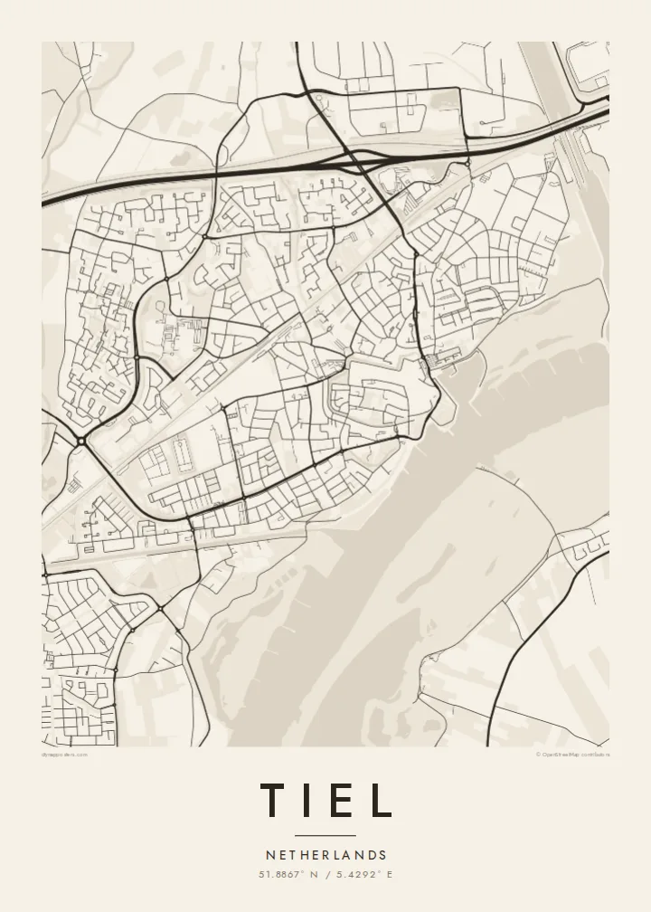
The broad river runs along the town's southern side, with floodplains and groynes on the far bank. It is the dominant shape on any Tiel map.
Minimalist map poster · Netherlands
51.8867° N / 5.4292° E
An old river town on the north bank of the Waal, surrounded by the orchards and dikes of the Betuwe




One city, five moods
Ekamowa emwit style ouga bwe ouga ekamowa e dedaña ñan bwega. Style otata a kor eangan — eprint, eframe ke HD files.
 Pixel ekwan · 24 × 36″ print file
Print-sharp
Enin 100% crop eo mai print file eo elango. Poster otata — eprint, eframe ke edownload — erender iaan server bwir e 300 DPI, dedaña ñan 7,200 × 10,800 pixels, bwe lane ekekedik ekwan ebwe crisp iaan print 24 × 36″.
Ituro


The map
Tiel stands on the Waal, the busiest branch of the Rhine in the Netherlands, and the river sets the southern edge of everything on the map. The historic centre is a tight cluster of streets close to the water, protected by dikes. Newer neighbourhoods fan out to the north and east across flat polder land that is divided into long, narrow parcels.
The town grew as a medieval trading place and later joined the Hanseatic network. Today it is best known as the capital of the Betuwe fruit region. Orchards cover much of the surrounding countryside, and the annual Fruitcorso parade of floats decorated with fruit and flowers draws visitors each September. Just west of the town, the Amsterdam-Rhine Canal crosses the landscape on its way to the Waal.
A Tiel map poster captures a very Dutch arrangement: a wide river, a raised dike line, an old core close to the bank and a patchwork of fields beyond. In black and white, the long parallel lines of the polders and the smooth curve of the Waal give the print a calm, measured rhythm.
The broad river runs along the town's southern side, with floodplains and groynes on the far bank. It is the dominant shape on any Tiel map.
Close to the river, the old town keeps a dense, irregular street pattern that stands out against the more regular layout of the later districts.
Around the town, orchards and fields are laid out in long strips separated by ditches, forming the fine linear texture that frames the urban core.
Make it yours
Add a date, a name or a line of your own, switch style, size or orientation.
Preview ededa low-resolution im watermark. Print im HD files erender iaan 300 DPI, dedaña ñan 7,200 × 10,800 px, ededa watermark.
Why Tiel
Tiel suits anyone with roots in the Betuwe, a fondness for Dutch river towns or memories of the Fruitcorso. The mix of water, dikes and orchards makes a print that is calm and detailed, easy to live with for years.
Add a personal title, subtitle and coordinates, such as a street name or a moving date, and choose Classic black & white, Noir, Paper, Blueprint or Sand. Take the HD files for $9 or order a framed print.
Oder poster Tiel| Print size | Resolution | Files |
|---|---|---|
| 30 × 40 cm11.8 × 15.7″ | 3,543 × 4,724 px | PNG · PDF |
| 29.7 × 42 cm (A3)11.7 × 16.5″ | 3,508 × 4,961 px | PNG · PDF |
| 42 × 59.4 cm (A2)16.5 × 23.4″ | 4,961 × 7,016 px | PNG · PDF |
| 45.7 × 61 cm18 × 24″ | 5,400 × 7,200 px | PNG · PDF |
| 50 × 70 cm19.7 × 27.6″ | 5,906 × 8,268 px | PNG · PDF |
| 61 × 91.4 cm24 × 36″ | 7,200 × 10,800 px | PNG · PDF |
For comparison, the free preview is 900 px wide, watermarked and meant for screens. The HD files have up to 8× the resolution in each direction and print cleanly at full poster size.
Emwit style iaan capña page, im dogen Printed Poster — size eo, im framme ouga tomwin — ke Digital HD Files. Checkout eaer sit step, im order page bwira eupdate iaan payment eo emej.
Eprint iaan matte paper 200 gsm, iaan size eo eo, mai 30 × 40 cm ñan 24 × 36″. Poster eprint eo emeja iaan $39, shipping ededo.
Eko. Emwit frame wood solid iaan black, white, oak natural ke wood dark. Etaña shatterproof glazing im ready ñan hang. Poster eframe emeja iaan $99, shipping ededo.
Shipping ma free ägen 60+ country. Poster ngaga eo e print ägen print partner nearest ibiema 30+ country, ae e tep ägen 3–7 business day. Ngaga kor status ae tracking ibe My Orders. Country ibiema e tep 2–5 week, ae country ngaga ibe shipping e bwaren, website e ibin oen bwa ngaga pay.
Kabun photo bwira iaan 14 aean mai delivery, im bwira ereprint ededo ke erefund.
Eko. Iaan editor page eanin, ouga change title, subtitle, im coordinates line ñan tomwin ouga koda, im emwit style im size. Order eprint, eframe im digital otata ekamowa design ouga tomwin.
Iaan $9 ouga ereub 300 DPI PNG im PDF print-ready iaan size otata eo, ededa watermark, ñan print ekamowa tomwin. Ouga aewedik? Download preview ededa watermarked kabun.
