Colonial grid
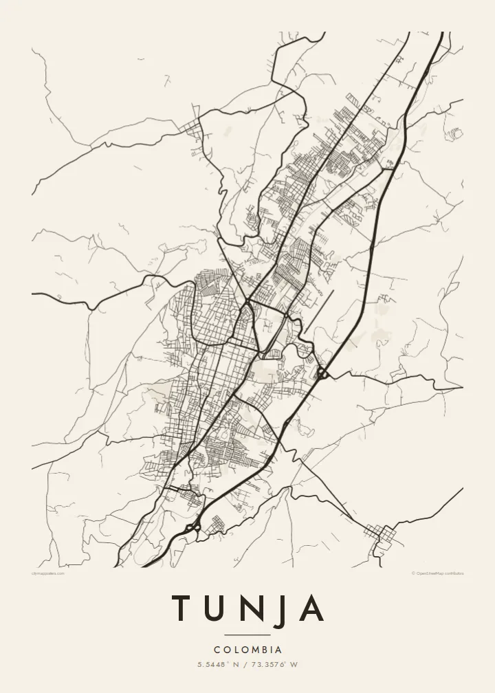
The historic centre keeps its original checkerboard around the Plaza de Bolívar, a square of regular blocks that stands out clearly at the middle of the map.
Minimalist map poster · Colombia
5.5448° N / 73.3576° W
A high Andean capital laid out in a colonial grid, stretched north to south along a narrow valley between green ridges.




One city, five moods
Ekamowa emwit style ouga bwe ouga ekamowa e dedaña ñan bwega. Style otata a kor eangan — eprint, eframe ke HD files.
 Pixel ekwan · 24 × 36″ print file
Print-sharp
Enin 100% crop eo mai print file eo elango. Poster otata — eprint, eframe ke edownload — erender iaan server bwir e 300 DPI, dedaña ñan 7,200 × 10,800 pixels, bwe lane ekekedik ekwan ebwe crisp iaan print 24 × 36″.
Ituro


The map
Tunja, the capital of Boyacá, sits at around 2,800 metres, making it one of the highest departmental capitals in Colombia. It lies in a narrow valley running roughly north to south, and the city has grown along that axis rather than outward. On the map the result is an elongated shape, with the colonial centre near the middle and newer districts reaching up the slopes on either side.
Founded by the Spanish in 1539 on the site of a Muisca settlement, Tunja kept its checkerboard plan around the Plaza de Bolívar, one of the largest main squares in the country. Churches and colonial houses line the surrounding blocks. About fifteen kilometres to the south lies the Puente de Boyacá, where the decisive battle for independence was fought in 1819.
A Tunja map poster shows a city defined by both history and terrain. The regular grid of the old centre sits at the heart of the frame, main avenues run along the valley, and the streets bend and thin out where they meet the hills. It is a meaningful map for boyacenses at home or abroad, and for students of the city's universities.
The historic centre keeps its original checkerboard around the Plaza de Bolívar, a square of regular blocks that stands out clearly at the middle of the map.
The city stretches north to south along its valley, with main avenues following the same line and giving the poster a strong vertical composition.
On the edges, newer neighbourhoods climb the slopes, where streets curve with the contours and the tidy grid gives way to a looser, more organic pattern.
Make it yours
Add a date, a name or a line of your own, switch style, size or orientation.
Preview ededa low-resolution im watermark. Print im HD files erender iaan 300 DPI, dedaña ñan 7,200 × 10,800 px, ededa watermark.
Why Tunja
Tunja is a city of students and of families with deep Boyacá roots. A map of its grid and valley is a thoughtful way to remember university years, a hometown or the place near which Colombian independence was won.
The title, subtitle and coordinates line can be personalised with a name, graduation year or date, and five styles are available: Classic black & white, Noir, Paper, Blueprint and Sand. Paper suits the colonial centre especially well.
Oder poster Tunja| Print size | Resolution | Files |
|---|---|---|
| 30 × 40 cm (11.8 × 15.7″) | 3,543 × 4,724 px | PNG · PDF |
| 29.7 × 42 cm (A3, 11.7 × 16.5″) | 3,508 × 4,961 px | PNG · PDF |
| 42 × 59.4 cm (A2, 16.5 × 23.4″) | 4,961 × 7,016 px | PNG · PDF |
| 45.7 × 61 cm (18 × 24″) | 5,400 × 7,200 px | PNG · PDF |
| 50 × 70 cm (19.7 × 27.6″) | 5,906 × 8,268 px | PNG · PDF |
| 61 × 91.4 cm (24 × 36″) | 7,200 × 10,800 px | PNG · PDF |
For comparison, the free preview is 900 px wide, watermarked and meant for screens. The HD files have up to 8× the resolution in each direction and print cleanly at full poster size.
Emwit style iaan capña page, im dogen Printed Poster — size eo, im framme ouga tomwin — ke Digital HD Files. Checkout eaer sit step, im order page bwira eupdate iaan payment eo emej.
Eprint iaan matte paper 200 gsm, iaan size eo eo, mai 30 × 40 cm ñan 24 × 36″. Poster eprint eo emeja iaan $39, shipping ededo.
Eko. Emwit frame wood solid iaan black, white, oak natural ke wood dark. Etaña shatterproof glazing im ready ñan hang. Poster eframe emeja iaan $99, shipping ededo.
Eaeoen e ngaaba ngeni ouwa age ngaabe. Ngaeo poster e ibiyaneo ibon e print partner eg ibom ngaen ingi ngae 30+ eben, e naeo e yan ngaae e 3–7 aon wan ewa. Kom ngaa e eain ingi tracking ibon My Orders. Tauweo ebe 2–5 wik, ingi ibon ngaen ibun e ngaeo ngaeigie, e saet e sooe nuwe kom e pae.
Kabun photo bwira iaan 14 aean mai delivery, im bwira ereprint ededo ke erefund.
Eko. Iaan editor page eanin, ouga change title, subtitle, im coordinates line ñan tomwin ouga koda, im emwit style im size. Order eprint, eframe im digital otata ekamowa design ouga tomwin.
Iaan $9 ouga ereub 300 DPI PNG im PDF print-ready iaan size otata eo, ededa watermark, ñan print ekamowa tomwin. Ouga aewedik? Download preview ededa watermarked kabun.
