The old harbour
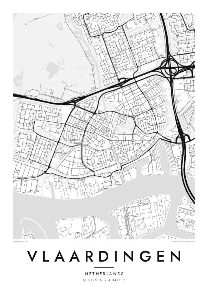
The Oude Haven reaches from the river into the centre, a slim channel lined with quays that recalls Vlaardingen's long history as a herring port.
Minimalist map poster · Netherlands
51.9125° N / 4.3417° E
A river town on the Nieuwe Maas, where an old herring harbour cuts inland between polders, docks and postwar neighbourhoods.


One city, five moods
Ekamowa emwit style ouga bwe ouga ekamowa e dedaña ñan bwega. Style otata a kor eangan — eprint, eframe ke HD files.
 Pixel ekwan · 24 × 36″ print file
Print-sharp
Enin 100% crop eo mai print file eo elango. Poster otata — eprint, eframe ke edownload — erender iaan server bwir e 300 DPI, dedaña ñan 7,200 × 10,800 pixels, bwe lane ekekedik ekwan ebwe crisp iaan print 24 × 36″.
Ituro


The map
Vlaardingen lies on the north bank of the Nieuwe Maas, between Schiedam and Maassluis, and the river sets the southern edge of the map. Ships heading to and from the port of Rotterdam pass along it, and the waterfront is lined with docks and industrial basins. Inland, the old harbour cuts north into the historic centre, a narrow strip of water flanked by quays.
The town received city rights in 1273, making it one of the oldest in Holland, and for centuries it lived from herring fishing. The Markt and the Grote Kerk sit close to the old harbour, surrounded by a compact grid of older streets. Beyond them, postwar neighbourhoods spread out in broader, more open patterns typical of Dutch planning.
North of the town the Broekpolder opens as a large green recreation area, framed by the ditches and straight edges of the polder landscape. A Vlaardingen map poster brings these layers together: river, harbour, old centre, housing estates and green polder, all compressed into a small area that still reads clearly from above.
The Oude Haven reaches from the river into the centre, a slim channel lined with quays that recalls Vlaardingen's long history as a herring port.
The broad river forms the southern border of the map, with docks and industrial basins along its bank marking the town's link to the Rotterdam port area.
To the north, the Broekpolder's lakes, paths and straight polder edges add a large green field to the poster, balancing the dense streets near the river.
Make it yours
Add a date, a name or a line of your own, switch style, size or orientation.
Preview ededa low-resolution im watermark. Print im HD files erender iaan 300 DPI, dedaña ñan 7,200 × 10,800 px, ededa watermark.
Why Vlaardingen
Vlaardingen suits people who know the Rotterdam region from the inside: those who grew up along the harbour, moved there for work, or still cycle out to the Broekpolder at weekends. The map captures a small city with a clear relationship to water.
The title, subtitle and coordinates line can be personalised with a street, a date or a family name. Five styles are available, and Blueprint gives the river and harbour a nautical feel, while Classic black & white keeps the old streets precise.
Oder poster Vlaardingen| Print size | Resolution | Files |
|---|---|---|
| 30 × 40 cm11.8 × 15.7″ | 3,543 × 4,724 px | PNG · PDF |
| 29.7 × 42 cm (A3)11.7 × 16.5″ | 3,508 × 4,961 px | PNG · PDF |
| 42 × 59.4 cm (A2)16.5 × 23.4″ | 4,961 × 7,016 px | PNG · PDF |
| 45.7 × 61 cm18 × 24″ | 5,400 × 7,200 px | PNG · PDF |
| 50 × 70 cm19.7 × 27.6″ | 5,906 × 8,268 px | PNG · PDF |
| 61 × 91.4 cm24 × 36″ | 7,200 × 10,800 px | PNG · PDF |
For comparison, the free preview is 900 px wide, watermarked and meant for screens. The HD files have up to 8× the resolution in each direction and print cleanly at full poster size.
Emwit style iaan capña page, im dogen Printed Poster — size eo, im framme ouga tomwin — ke Digital HD Files. Checkout eaer sit step, im order page bwira eupdate iaan payment eo emej.
Eprint iaan matte paper 200 gsm, iaan size eo eo, mai 30 × 40 cm ñan 24 × 36″. Poster eprint eo emeja iaan $39, shipping ededo.
Eko. Emwit frame wood solid iaan black, white, oak natural ke wood dark. Etaña shatterproof glazing im ready ñan hang. Poster eframe emeja iaan $99, shipping ededo.
Eaeoen e ngaaba ngeni ouwa age ngaabe. Ngaeo poster e ibiyaneo ibon e print partner eg ibom ngaen ingi ngae 30+ eben, e naeo e yan ngaae e 3–7 aon wan ewa. Kom ngaa e eain ingi tracking ibon My Orders. Tauweo ebe 2–5 wik, ingi ibon ngaen ibun e ngaeo ngaeigie, e saet e sooe nuwe kom e pae.
Kabun photo bwira iaan 14 aean mai delivery, im bwira ereprint ededo ke erefund.
Eko. Iaan editor page eanin, ouga change title, subtitle, im coordinates line ñan tomwin ouga koda, im emwit style im size. Order eprint, eframe im digital otata ekamowa design ouga tomwin.
Iaan $9 ouga ereub 300 DPI PNG im PDF print-ready iaan size otata eo, ededa watermark, ñan print ekamowa tomwin. Ouga aewedik? Download preview ededa watermarked kabun.
