Two rivers
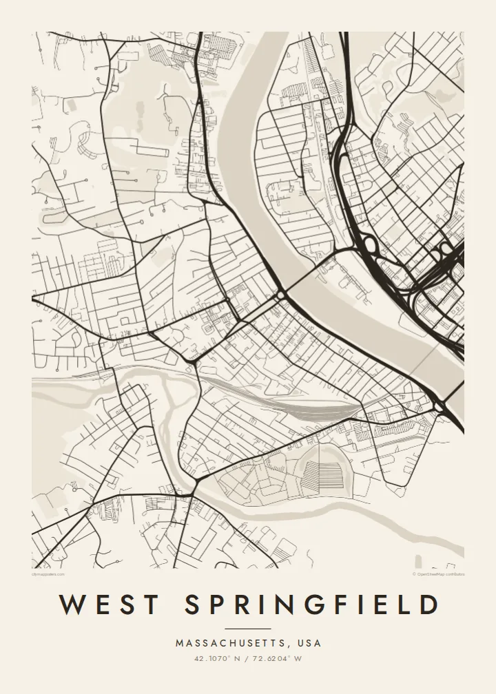
The Connecticut River to the east and the Westfield River to the south frame the town with wide curves of water, giving the map natural borders on two sides.
Minimalist map poster · United States
42.1070° N / 72.6204° W
A town on the west bank of the Connecticut River, bounded by two rivers and crossed by highways and rail yards.




One city, five moods
Ekamowa emwit style ouga bwe ouga ekamowa e dedaña ñan bwega. Style otata a kor eangan — eprint, eframe ke HD files.
 Pixel ekwan · 24 × 36″ print file
Print-sharp
Enin 100% crop eo mai print file eo elango. Poster otata — eprint, eframe ke edownload — erender iaan server bwir e 300 DPI, dedaña ñan 7,200 × 10,800 pixels, bwe lane ekekedik ekwan ebwe crisp iaan print 24 × 36″.
Ituro


The map
West Springfield faces the city of Springfield across the Connecticut River, and water defines two of its sides. The broad river runs along the eastern edge, while the Westfield River curves along the south before joining it. From above, bridges reach across to Springfield, and the town's streets spread west from the riverbanks toward higher, more wooded ground.
The street pattern mixes several eras. There are older neighbourhoods of tight residential streets near the river, long commercial strips lined with car lots and stores, and large rail yards and highway ramps where interstate routes pass through. A West Springfield map poster brings together this mix of residential grid, infrastructure and river edge in one clear composition.
The town is best known as the home of the Eastern States Exposition, the Big E, the largest fair in New England. It is held every autumn on grounds where each of the six New England states has its own replica statehouse. The fairgrounds appear on the map as a large, distinctive open area near the Westfield River.
The Connecticut River to the east and the Westfield River to the south frame the town with wide curves of water, giving the map natural borders on two sides.
The Eastern States Exposition grounds form a broad open space with exhibition halls and the row of state buildings, an unusual shape among the surrounding streets.
Several bridges carry roads and rail across the Connecticut River, linking the town to downtown Springfield and drawing strong lines over the water.
Make it yours
Add a date, a name or a line of your own, switch style, size or orientation.
Preview ededa low-resolution im watermark. Print im HD files erender iaan 300 DPI, dedaña ñan 7,200 × 10,800 px, ededa watermark.
Why West Springfield
For many New Englanders, West Springfield means autumn at the Big E, and for many more it means home. A map of the town, with its rivers and bridges, makes a good gift for a new homeowner, a graduate or someone who has moved away from the Pioneer Valley.
Edit the title, subtitle and coordinates line, then choose Classic black & white, Noir, Paper, Blueprint or Sand. Digital files come in six sizes, including 18×24″ and 24×36″. You can also order a matte printed poster with an optional wooden frame.
Oder poster West Springfield| Print size | Resolution | Files |
|---|---|---|
| 30 × 40 cm11.8 × 15.7″ | 3,543 × 4,724 px | PNG · PDF |
| 29.7 × 42 cm (A3)11.7 × 16.5″ | 3,508 × 4,961 px | PNG · PDF |
| 42 × 59.4 cm (A2)16.5 × 23.4″ | 4,961 × 7,016 px | PNG · PDF |
| 45.7 × 61 cm18 × 24″ | 5,400 × 7,200 px | PNG · PDF |
| 50 × 70 cm19.7 × 27.6″ | 5,906 × 8,268 px | PNG · PDF |
| 61 × 91.4 cm24 × 36″ | 7,200 × 10,800 px | PNG · PDF |
For comparison, the free preview is 900 px wide, watermarked and meant for screens. The HD files have up to 8× the resolution in each direction and print cleanly at full poster size.
Emwit style iaan capña page, im dogen Printed Poster — size eo, im framme ouga tomwin — ke Digital HD Files. Checkout eaer sit step, im order page bwira eupdate iaan payment eo emej.
Eprint iaan matte paper 200 gsm, iaan size eo eo, mai 30 × 40 cm ñan 24 × 36″. Poster eprint eo emeja iaan $39, shipping ededo.
Eko. Emwit frame wood solid iaan black, white, oak natural ke wood dark. Etaña shatterproof glazing im ready ñan hang. Poster eframe emeja iaan $99, shipping ededo.
Shipping ma free ägen 60+ country. Poster ngaga eo e print ägen print partner nearest ibiema 30+ country, ae e tep ägen 3–7 business day. Ngaga kor status ae tracking ibe My Orders. Country ibiema e tep 2–5 week, ae country ngaga ibe shipping e bwaren, website e ibin oen bwa ngaga pay.
Kabun photo bwira iaan 14 aean mai delivery, im bwira ereprint ededo ke erefund.
Eko. Iaan editor page eanin, ouga change title, subtitle, im coordinates line ñan tomwin ouga koda, im emwit style im size. Order eprint, eframe im digital otata ekamowa design ouga tomwin.
Iaan $9 ouga ereub 300 DPI PNG im PDF print-ready iaan size otata eo, ededa watermark, ñan print ekamowa tomwin. Ouga aewedik? Download preview ededa watermarked kabun.
