Utah grid
Wide, straight streets aligned to the compass form a regular pattern that repeats across the city, typical of settlements founded by Latter-day Saint pioneers.
Fakatino mape mukamuka · United States
40.3769° N / 111.7958° W
A Utah valley grid rising from the shore of Utah Lake toward the mouth of a steep canyon under Mount Timpanogos.




Taha e taone, lima e onoonoaga
Tapaki e taha puhala ke kitia ai ki luga he puipui. Kua tatai e totogi he tau puhala oti — pete he lolomi, poloka, po ke faila HD.
 Tau pikselo mooli · faila lolomi 24 × 36″
Maama mitaki ke lolomi
Ko e 100% e fahi mooli mai he faila lolomi. Ko e tau poster oti — pete kua lolomi, poloka, po ke utu hifo — kua taute ke he ha mautolu a tau tokoluga (server) ke he 300 DPI, hokotia ke he 7,200 × 10,800 piksela, ke maeke ai e tau ala ikiiki tote ke maaliali fakamitaki he lolomi 24 × 36″.
He Pā


Ko e mape
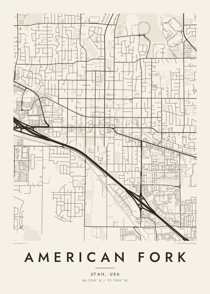
American Fork lies at the northern end of Utah Valley, between the shore of Utah Lake and the steep Wasatch front. Its streets follow the numbered grid typical of Utah towns, with wide blocks running straight toward the mountains. From above, the grid climbs gently from the lakeside flats to the foothills, and Interstate 15 crosses it as a long diagonal-free band.
The city takes its name from the American Fork River, which leaves its canyon to the northeast and runs down through the valley toward the lake. American Fork Canyon is home to Timpanogos Cave National Monument, and Mount Timpanogos, one of the most recognisable peaks in the Wasatch, rises above the city to the east.
An American Fork map poster shows the order of a planned Western town against a dramatic natural setting. The grid is regular and calm, the river adds one winding line, and the canyon and lakeshore frame the edges. It is a map that makes sense straight away to anyone who has driven through Utah Valley.
Wide, straight streets aligned to the compass form a regular pattern that repeats across the city, typical of settlements founded by Latter-day Saint pioneers.
The river runs out of its canyon and down through the valley toward Utah Lake, adding the one natural curve through the city's straight lines.
Utah Lake's shore lies to the southwest and the canyon mouth to the northeast, framing the city between water and mountains.
Taute ke ha hau
Lafi e aho, taha higoa po ke taha kupu haau, hiki e fakatino, lahi po ke tuaga.
Ko e kitiaaga nakai totogi kua tote e maaliali mo e fakamailoga vai. Ko e tau lolomi mo e tau faila HD kua taute ke he 300 DPI, hokotia ke he 7,200 × 10,800 px, nakai fai fakamailoga vai.
Ko e ha American Fork
American Fork is a place where many families put down roots, and the map suits a first home, a new job at one of the nearby tech campuses or a family that has lived here for generations. The grid looks especially clean on a wall.
Personalise the title and subtitle, add a date or edit the coordinates line, then choose Classic black and white, Noir, Paper, Blueprint or Sand. The HD download costs $9 and includes six print sizes, including 18×24 and 24×36 inches. Printed posters with an optional frame are also available.
Talaage e poster American Fork| Lahi he lolomi | Maama | Tau faila |
|---|---|---|
| 30 × 40 cm11.8 × 15.7″ | 3,543 × 4,724 px | PNG · PDF |
| 29.7 × 42 cm (A3)11.7 × 16.5″ | 3,508 × 4,961 px | PNG · PDF |
| 42 × 59.4 cm (A2)16.5 × 23.4″ | 4,961 × 7,016 px | PNG · PDF |
| 45.7 × 61 cm18 × 24″ | 5,400 × 7,200 px | PNG · PDF |
| 50 × 70 cm19.7 × 27.6″ | 5,906 × 8,268 px | PNG · PDF |
| 61 × 91.4 cm24 × 36″ | 7,200 × 10,800 px | PNG · PDF |
Ke fakatatai, ko e fakatino noa kua 900 px e laulahi, fai fakamailoga mo e mo e tau mata komipiuta ni. Ko e tau faila HD kua ato hoko ke he 8× e maama ke he tau faahi takitaha mo e lolomi mitaki he lahi katoa he fakatino.
Fifili e taha puhala i luga he kupega, ti fifili e Poster Lolomi — e lahi mo e, kaeke ke manako ai koe, taha poloka — po ke Tau Faila HD Fakaeletonika. Ko e fakaotiaga totogi ko e taha gahua ni, ti ko e kupega he hau a talaaga ka fakafou fakahaga i mua he fakaotiaga e totogi.
Kua lolomi ai ke he pepa mitaki 200 gsm matte he taha he tau lahi ono, mai he 30 × 40 cm ke hoko ke he 24 × 36″. Kamata e tau poster lolomi mai he $39, kua putoia ai e utaaga.
E. Fifili e poloka akau malolō ke he lanu uli, tea, akau oki mooli, po ke akau pouli. Kua fakalataha mo e sioga malolō nakai malepe ti kua mautali ke tautau. Kamata e tau poster poloka mai he $99, kua putoia ai e utaaga.
Nakai totogi e fakafano ke he motu 60+. Ko e fakatino taha kua lolomi he fenoga lolomi ha mautolu kua tata mo e tau motu 30+, kua hoko mai he tau aho gahua 3–7. Maeke ia koe ke kikite e tuaga mo e fakamuitua he lalo he Haku Tau Fakatonu. Ke he falu motu kua 2–5 e tau tapu, ti ka nakai fakafano a mautolu ki ai, to fakaha he api tupe ia ki mua he totogi.
Fakafano mai e taha ata ki a mautolu he loto he 14 e tau aho tali mai he hokoaga, ti to lolomi foki e mautolu nakai totogi po ke liu atu e totogi ki a koe.
E. He editor i luga he kupega nei, hikihiki e matakupu, e matakupu lalo mo e laini coordinates ke he taha mena kua manako a koe ki ai, ti fifili e puhala mo e lahi. Ko e tau talaaga lolomi, poloka mo e fakaeletonika oti kua fakaaoga tonu e hau a fakatino.
Ma e $9 ka moua e koe e tau faila PNG 300 DPI mo e PDF kua mautali ke lolomi he tau lahi ono oti, nakai fai fakamailoga vai, ke lolomi i fe mena. Nakai maopoopo agaia? Utu hifo fakamua e kitiaaga nakai totogi ne fai fakamailoga vai.
Tata mai
