Lake Basotu
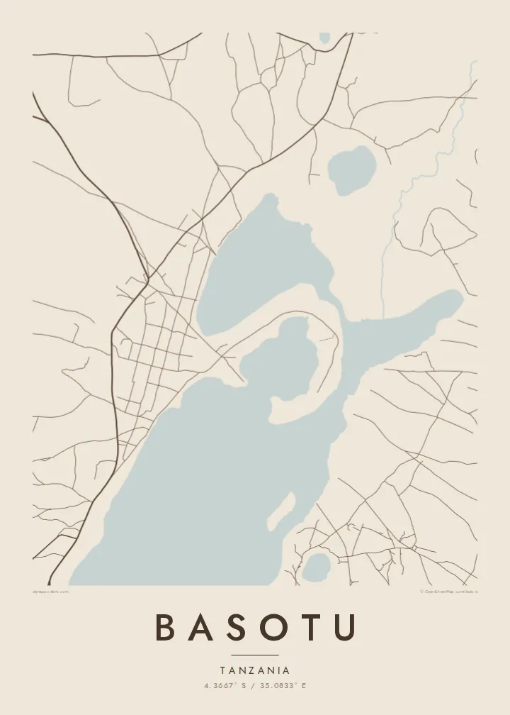
The lake beside the town is the dominant form on the map. Its solid shape anchors the composition and gives the settlement its outline along the shore.
Fakatino mape mukamuka · Tanzania
4.3667° S / 35.0833° E
A small Hanang town beside the waters of Lake Basotu, with open farmland and scattered tracks spreading in every direction.


Taha e taone, lima e onoonoaga
Tapaki e taha puhala ke kitia ai ki luga he puipui. Kua tatai e totogi he tau puhala oti — pete he lolomi, poloka, po ke faila HD.
 Tau pikselo mooli · faila lolomi 24 × 36″
Maama mitaki ke lolomi
Ko e 100% e fahi mooli mai he faila lolomi. Ko e tau poster oti — pete kua lolomi, poloka, po ke utu hifo — kua taute ke he ha mautolu a tau tokoluga (server) ke he 300 DPI, hokotia ke he 7,200 × 10,800 piksela, ke maeke ai e tau ala ikiiki tote ke maaliali fakamitaki he lolomi 24 × 36″.
He Pā


Ko e mape
Basotu lies in Hanang District of Manyara Region, in the highlands of northern Tanzania. From above, the most striking feature is water. Lake Basotu sits right beside the town, a compact body of water that gives the map a clear focal point in otherwise open country. Houses and compounds cluster near its shore, and unpaved roads fan out toward villages and fields.
The wider district is dominated by Mount Hanang, one of the highest peaks in Tanzania, which rises to the east. The plains around Basotu are farming and grazing land, home to Barabaig and Iraqw communities among others, and large wheat farms have been part of the area's story. On the map this appears as broad, lightly marked terrain rather than dense streets.
Because the settlement is small, a Basotu map poster works best as a portrait of the place and its setting together: the shape of the lake, the loose ring of buildings and the few tracks heading out across the land. It is a sparse, calm composition, and that restraint is exactly what makes it read well in black and white.
The lake beside the town is the dominant form on the map. Its solid shape anchors the composition and gives the settlement its outline along the shore.
Unpaved roads leave the town in several directions toward farms and neighbouring villages. They draw thin lines across open ground and show how much space surrounds Basotu.
The town belongs to the district named after Mount Hanang, a free-standing volcanic mountain to the east that defines the wider landscape of this part of Manyara.
Taute ke ha hau
Lafi e aho, taha higoa po ke taha kupu haau, hiki e fakatino, lahi po ke tuaga.
Ko e kitiaaga nakai totogi kua tote e maaliali mo e fakamailoga vai. Ko e tau lolomi mo e tau faila HD kua taute ke he 300 DPI, hokotia ke he 7,200 × 10,800 px, nakai fai fakamailoga vai.
Ko e ha Basotu
A map of Basotu usually belongs to someone with a direct connection: people who were born here, taught or worked in the district, or spent time on a project near the lake. It records a quiet place that rarely appears on any printed map.
You can personalise the title, subtitle and coordinates line, perhaps with the years you lived there. The design comes in five styles (Classic black & white, Noir, Paper, Blueprint and Sand) and can be downloaded as 300 DPI files or ordered as a printed poster.
Talaage e poster Basotu| Lahi he lolomi | Maama | Tau faila |
|---|---|---|
| 30 × 40 cm11.8 × 15.7″ | 3,543 × 4,724 px | PNG · PDF |
| 29.7 × 42 cm (A3)11.7 × 16.5″ | 3,508 × 4,961 px | PNG · PDF |
| 42 × 59.4 cm (A2)16.5 × 23.4″ | 4,961 × 7,016 px | PNG · PDF |
| 45.7 × 61 cm18 × 24″ | 5,400 × 7,200 px | PNG · PDF |
| 50 × 70 cm19.7 × 27.6″ | 5,906 × 8,268 px | PNG · PDF |
| 61 × 91.4 cm24 × 36″ | 7,200 × 10,800 px | PNG · PDF |
Ke fakatatai, ko e fakatino noa kua 900 px e laulahi, fai fakamailoga mo e mo e tau mata komipiuta ni. Ko e tau faila HD kua ato hoko ke he 8× e maama ke he tau faahi takitaha mo e lolomi mitaki he lahi katoa he fakatino.
Fifili e taha puhala i luga he kupega, ti fifili e Poster Lolomi — e lahi mo e, kaeke ke manako ai koe, taha poloka — po ke Tau Faila HD Fakaeletonika. Ko e fakaotiaga totogi ko e taha gahua ni, ti ko e kupega he hau a talaaga ka fakafou fakahaga i mua he fakaotiaga e totogi.
Kua lolomi ai ke he pepa mitaki 200 gsm matte he taha he tau lahi ono, mai he 30 × 40 cm ke hoko ke he 24 × 36″. Kamata e tau poster lolomi mai he $39, kua putoia ai e utaaga.
E. Fifili e poloka akau malolō ke he lanu uli, tea, akau oki mooli, po ke akau pouli. Kua fakalataha mo e sioga malolō nakai malepe ti kua mautali ke tautau. Kamata e tau poster poloka mai he $99, kua putoia ai e utaaga.
Nakai totogi e fakafano ke he motu 60+. Ko e fakatino taha kua lolomi he fenoga lolomi ha mautolu kua tata mo e tau motu 30+, kua hoko mai he tau aho gahua 3–7. Maeke ia koe ke kikite e tuaga mo e fakamuitua he lalo he Haku Tau Fakatonu. Ke he falu motu kua 2–5 e tau tapu, ti ka nakai fakafano a mautolu ki ai, to fakaha he api tupe ia ki mua he totogi.
Fakafano mai e taha ata ki a mautolu he loto he 14 e tau aho tali mai he hokoaga, ti to lolomi foki e mautolu nakai totogi po ke liu atu e totogi ki a koe.
E. He editor i luga he kupega nei, hikihiki e matakupu, e matakupu lalo mo e laini coordinates ke he taha mena kua manako a koe ki ai, ti fifili e puhala mo e lahi. Ko e tau talaaga lolomi, poloka mo e fakaeletonika oti kua fakaaoga tonu e hau a fakatino.
Ma e $9 ka moua e koe e tau faila PNG 300 DPI mo e PDF kua mautali ke lolomi he tau lahi ono oti, nakai fai fakamailoga vai, ke lolomi i fe mena. Nakai maopoopo agaia? Utu hifo fakamua e kitiaaga nakai totogi ne fai fakamailoga vai.
Tata mai
