The Misbourne valley
The River Misbourne runs through the village along the valley floor. It is a narrow chalk stream that sometimes runs low, and it sets the direction the whole settlement stretches in.
Fakatino mape mukamuka · United Kingdom
51.6088° N / 0.5562° W
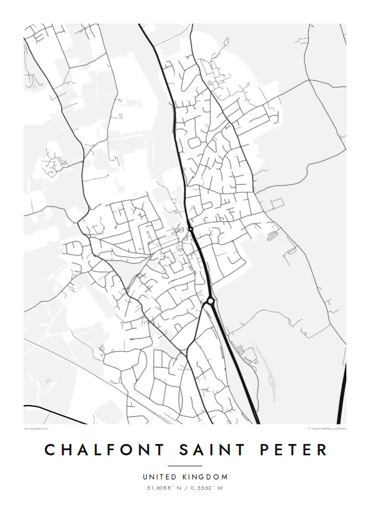
A large Buckinghamshire village drawn along the Misbourne valley, its old centre ringed by curving cul-de-sacs, commons and wooded edges
Taha e taone, lima e onoonoaga
Tapaki e taha puhala ke kitia ai ki luga he puipui. Kua tatai e totogi he tau puhala oti — pete he lolomi, poloka, po ke faila HD.
 Tau pikselo mooli · faila lolomi 24 × 36″
Maama mitaki ke lolomi
Ko e 100% e fahi mooli mai he faila lolomi. Ko e tau poster oti — pete kua lolomi, poloka, po ke utu hifo — kua taute ke he ha mautolu a tau tokoluga (server) ke he 300 DPI, hokotia ke he 7,200 × 10,800 piksela, ke maeke ai e tau ala ikiiki tote ke maaliali fakamitaki he lolomi 24 × 36″.
He Pā


Ko e mape
Seen from above, Chalfont Saint Peter follows the shallow valley of the River Misbourne, a small chalk stream that runs south-east through the Chiltern foothills. The older core sits low beside the water and the main road, and newer housing climbs the slopes on either side. Houses thin out into fields, hedgerows and patches of woodland, so the village keeps a clear outline and never blurs into its neighbours.
The street pattern shows how the place grew. A handful of older roads meet near the village centre. Around them, twentieth-century estates fill the rest of the map with looping crescents, closes and short dead ends, which give the drawing a soft, rounded texture. With around twenty thousand residents, Chalfont Saint Peter is often described as one of the largest villages in England, and the density of lines on the map shows it.
A Chalfont Saint Peter map poster reduces all of this to linework: the thin thread of the Misbourne, the main road through the valley, and open spaces such as Gold Hill Common. Gerrards Cross lies close to the south, and Chalfont St Giles sits further up the valley to the north-west. Printed in monochrome, the map reads as one compact settlement set into the green belt west of London.
The River Misbourne runs through the village along the valley floor. It is a narrow chalk stream that sometimes runs low, and it sets the direction the whole settlement stretches in.
Most of the map is made up of residential estates whose curving roads and closes branch off a few older through-routes. From above they form a dense, rounded pattern.
Open ground such as Gold Hill Common and the surrounding fields and woods break up the housing. On the poster they show as calm blank spaces around the edges of the village.
Taute ke ha hau
Lafi e aho, taha higoa po ke taha kupu haau, hiki e fakatino, lahi po ke tuaga.
Ko e kitiaaga nakai totogi kua tote e maaliali mo e fakamailoga vai. Ko e tau lolomi mo e tau faila HD kua taute ke he 300 DPI, hokotia ke he 7,200 × 10,800 px, nakai fai fakamailoga vai.
Ko e ha Chalfont Saint Peter
Chalfont Saint Peter is the kind of place people remember in detail: the walk to school, the road down to the village centre, the common at the weekend. The map keeps those routes in one frame. It suits people who grew up here, families who have just moved in, and anyone who left for London and still thinks of it as home.
You can change the title, subtitle and coordinates line to mark a street, a family name or a meaningful date. There are five styles: Classic black & white, Noir, Paper, Blueprint and Sand. HD files cost $9, and you can also order a matte print, framed if you like, from print partners in more than 30 countries.
Talaage e poster Chalfont Saint Peter| Lahi he lolomi | Maama | Tau faila |
|---|---|---|
| 30 × 40 cm11.8 × 15.7″ | 3,543 × 4,724 px | PNG · PDF |
| 29.7 × 42 cm (A3)11.7 × 16.5″ | 3,508 × 4,961 px | PNG · PDF |
| 42 × 59.4 cm (A2)16.5 × 23.4″ | 4,961 × 7,016 px | PNG · PDF |
| 45.7 × 61 cm18 × 24″ | 5,400 × 7,200 px | PNG · PDF |
| 50 × 70 cm19.7 × 27.6″ | 5,906 × 8,268 px | PNG · PDF |
| 61 × 91.4 cm24 × 36″ | 7,200 × 10,800 px | PNG · PDF |
Ke fakatatai, ko e fakatino noa kua 900 px e laulahi, fai fakamailoga mo e mo e tau mata komipiuta ni. Ko e tau faila HD kua ato hoko ke he 8× e maama ke he tau faahi takitaha mo e lolomi mitaki he lahi katoa he fakatino.
Fifili e taha puhala i luga he kupega, ti fifili e Poster Lolomi — e lahi mo e, kaeke ke manako ai koe, taha poloka — po ke Tau Faila HD Fakaeletonika. Ko e fakaotiaga totogi ko e taha gahua ni, ti ko e kupega he hau a talaaga ka fakafou fakahaga i mua he fakaotiaga e totogi.
Kua lolomi ai ke he pepa mitaki 200 gsm matte he taha he tau lahi ono, mai he 30 × 40 cm ke hoko ke he 24 × 36″. Kamata e tau poster lolomi mai he $39, kua putoia ai e utaaga.
E. Fifili e poloka akau malolō ke he lanu uli, tea, akau oki mooli, po ke akau pouli. Kua fakalataha mo e sioga malolō nakai malepe ti kua mautali ke tautau. Kamata e tau poster poloka mai he $99, kua putoia ai e utaaga.
Nakai totogi e fakafano ke he motu 60+. Ko e fakatino taha kua lolomi he fenoga lolomi ha mautolu kua tata mo e tau motu 30+, kua hoko mai he tau aho gahua 3–7. Maeke ia koe ke kikite e tuaga mo e fakamuitua he lalo he Haku Tau Fakatonu. Ke he falu motu kua 2–5 e tau tapu, ti ka nakai fakafano a mautolu ki ai, to fakaha he api tupe ia ki mua he totogi.
Fakafano mai e taha ata ki a mautolu he loto he 14 e tau aho tali mai he hokoaga, ti to lolomi foki e mautolu nakai totogi po ke liu atu e totogi ki a koe.
E. He editor i luga he kupega nei, hikihiki e matakupu, e matakupu lalo mo e laini coordinates ke he taha mena kua manako a koe ki ai, ti fifili e puhala mo e lahi. Ko e tau talaaga lolomi, poloka mo e fakaeletonika oti kua fakaaoga tonu e hau a fakatino.
Ma e $9 ka moua e koe e tau faila PNG 300 DPI mo e PDF kua mautali ke lolomi he tau lahi ono oti, nakai fai fakamailoga vai, ke lolomi i fe mena. Nakai maopoopo agaia? Utu hifo fakamua e kitiaaga nakai totogi ne fai fakamailoga vai.
Tata mai
