The reservoir loop
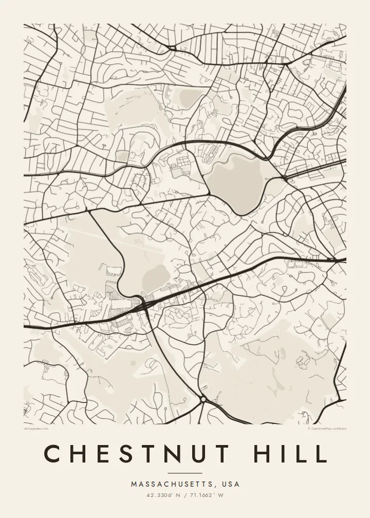
The Chestnut Hill Reservoir is the largest open shape in the area. Its uneven shoreline and surrounding path make a strong pale form against the finer street pattern around it.
Fakatino mape mukamuka · United States
42.3306° N / 71.1662° W
A leafy village where Boston, Brookline and Newton meet, drawn around a reservoir loop and the curving line of Commonwealth Avenue




Taha e taone, lima e onoonoaga
Tapaki e taha puhala ke kitia ai ki luga he puipui. Kua tatai e totogi he tau puhala oti — pete he lolomi, poloka, po ke faila HD.
 Tau pikselo mooli · faila lolomi 24 × 36″
Maama mitaki ke lolomi
Ko e 100% e fahi mooli mai he faila lolomi. Ko e tau poster oti — pete kua lolomi, poloka, po ke utu hifo — kua taute ke he ha mautolu a tau tokoluga (server) ke he 300 DPI, hokotia ke he 7,200 × 10,800 piksela, ke maeke ai e tau ala ikiiki tote ke maaliali fakamitaki he lolomi 24 × 36″.
He Pā


Ko e mape
Chestnut Hill is not a city with its own borders. It is a village that sits across three municipalities: the western edge of Boston, the southern part of Newton and a corner of Brookline. On a map you do not see a grid. You see winding residential roads, large lots and green space, with a few long arteries crossing through on their way out of the city.
The clearest shape is the Chestnut Hill Reservoir, an irregular basin with a path running around its edge. Boston College's campus lies just to the west, a dense group of buildings on rising ground. Commonwealth Avenue runs past with its wide median. Boylston Street, which is Route 9, runs further south and carries most of the commercial traffic. Light rail branches reach into the area from downtown Boston.
A Chestnut Hill map poster shows a suburb planned around landscape rather than blocks. Curved streets follow the terrain, ponds and wooded parcels break up the housing, and the reservoir anchors the whole composition. Each spring the Boston Marathon comes along Commonwealth Avenue on its way toward the city, climbing the Newton hills that end near the college.
The Chestnut Hill Reservoir is the largest open shape in the area. Its uneven shoreline and surrounding path make a strong pale form against the finer street pattern around it.
On the high ground west of the reservoir, the college's buildings, quads and paths form a denser cluster. It is one of the few places here where the map tightens.
The avenue's divided carriageway sweeps through the village in a long curve. Marathon runners take this route toward Boston after climbing the hills in Newton.
Taute ke ha hau
Lafi e aho, taha higoa po ke taha kupu haau, hiki e fakatino, lahi po ke tuaga.
Ko e kitiaaga nakai totogi kua tote e maaliali mo e fakamailoga vai. Ko e tau lolomi mo e tau faila HD kua taute ke he 300 DPI, hokotia ke he 7,200 × 10,800 px, nakai fai fakamailoga vai.
Ko e ha Chestnut Hill
People who studied at Boston College, ran the marathon or lived near the reservoir often want a map of this area. It records a specific stretch of ground: the path they walked around the water, the campus above it, and the quiet streets that link the three towns.
Add your own title, a subtitle such as a graduation year, and the coordinates line. Then pick one of five styles. Classic black and white or Paper suit the area's soft, green layout. Blueprint emphasises the reservoir and the road curves.
Talaage e poster Chestnut Hill| Lahi he lolomi | Maama | Tau faila |
|---|---|---|
| 30 × 40 cm11.8 × 15.7″ | 3,543 × 4,724 px | PNG · PDF |
| 29.7 × 42 cm (A3)11.7 × 16.5″ | 3,508 × 4,961 px | PNG · PDF |
| 42 × 59.4 cm (A2)16.5 × 23.4″ | 4,961 × 7,016 px | PNG · PDF |
| 45.7 × 61 cm18 × 24″ | 5,400 × 7,200 px | PNG · PDF |
| 50 × 70 cm19.7 × 27.6″ | 5,906 × 8,268 px | PNG · PDF |
| 61 × 91.4 cm24 × 36″ | 7,200 × 10,800 px | PNG · PDF |
Ke fakatatai, ko e fakatino noa kua 900 px e laulahi, fai fakamailoga mo e mo e tau mata komipiuta ni. Ko e tau faila HD kua ato hoko ke he 8× e maama ke he tau faahi takitaha mo e lolomi mitaki he lahi katoa he fakatino.
Fifili e taha puhala i luga he kupega, ti fifili e Poster Lolomi — e lahi mo e, kaeke ke manako ai koe, taha poloka — po ke Tau Faila HD Fakaeletonika. Ko e fakaotiaga totogi ko e taha gahua ni, ti ko e kupega he hau a talaaga ka fakafou fakahaga i mua he fakaotiaga e totogi.
Kua lolomi ai ke he pepa mitaki 200 gsm matte he taha he tau lahi ono, mai he 30 × 40 cm ke hoko ke he 24 × 36″. Kamata e tau poster lolomi mai he $39, kua putoia ai e utaaga.
E. Fifili e poloka akau malolō ke he lanu uli, tea, akau oki mooli, po ke akau pouli. Kua fakalataha mo e sioga malolō nakai malepe ti kua mautali ke tautau. Kamata e tau poster poloka mai he $99, kua putoia ai e utaaga.
Nakai totogi e fakafano ke he motu 60+. Ko e fakatino taha kua lolomi he fenoga lolomi ha mautolu kua tata mo e tau motu 30+, kua hoko mai he tau aho gahua 3–7. Maeke ia koe ke kikite e tuaga mo e fakamuitua he lalo he Haku Tau Fakatonu. Ke he falu motu kua 2–5 e tau tapu, ti ka nakai fakafano a mautolu ki ai, to fakaha he api tupe ia ki mua he totogi.
Fakafano mai e taha ata ki a mautolu he loto he 14 e tau aho tali mai he hokoaga, ti to lolomi foki e mautolu nakai totogi po ke liu atu e totogi ki a koe.
E. He editor i luga he kupega nei, hikihiki e matakupu, e matakupu lalo mo e laini coordinates ke he taha mena kua manako a koe ki ai, ti fifili e puhala mo e lahi. Ko e tau talaaga lolomi, poloka mo e fakaeletonika oti kua fakaaoga tonu e hau a fakatino.
Ma e $9 ka moua e koe e tau faila PNG 300 DPI mo e PDF kua mautali ke lolomi he tau lahi ono oti, nakai fai fakamailoga vai, ke lolomi i fe mena. Nakai maopoopo agaia? Utu hifo fakamua e kitiaaga nakai totogi ne fai fakamailoga vai.
Tata mai
