The valley spine
A main avenue follows the valley floor lengthwise, and most streets branch off it at angles dictated by the slopes, producing an elongated, organic street pattern.
Fakatino mape mukamuka · Colombia
4.8366° N / 75.6693° W
An Andean city spread along a valley and its ravines, joined to Pereira by a long cable-stayed bridge over the Otún.


Taha e taone, lima e onoonoaga
Tapaki e taha puhala ke kitia ai ki luga he puipui. Kua tatai e totogi he tau puhala oti — pete he lolomi, poloka, po ke faila HD.
 Tau pikselo mooli · faila lolomi 24 × 36″
Maama mitaki ke lolomi
Ko e 100% e fahi mooli mai he faila lolomi. Ko e tau poster oti — pete kua lolomi, poloka, po ke utu hifo — kua taute ke he ha mautolu a tau tokoluga (server) ke he 300 DPI, hokotia ke he 7,200 × 10,800 piksela, ke maeke ai e tau ala ikiiki tote ke maaliali fakamitaki he lolomi 24 × 36″.
He Pā


Ko e mape
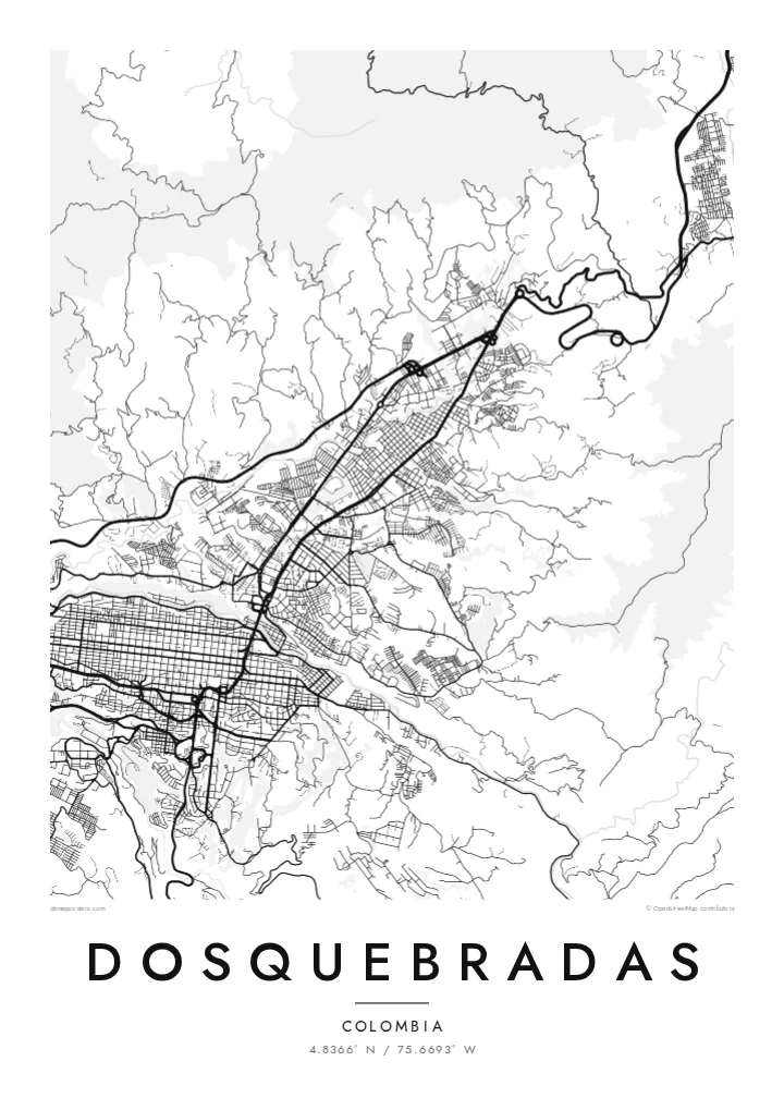
Dosquebradas takes its name from the two ravines that shaped its first settlement, and the map makes the logic clear. The city lies in a narrow valley in Colombia's central Andes, with housing climbing the green slopes on both sides and a main avenue running along the flatter ground in between, following the lie of the land rather than a grid.
To the south, the Otún River separates Dosquebradas from Pereira, the departmental capital, and the two now function as one metropolitan area. The link between them is the César Gaviria Trujillo Viaduct, a cable-stayed bridge opened in 1997 that spans the river canyon and remains one of the most recognisable structures in the region.
The city sits in Colombia's coffee region, whose cultural landscape is recognised by UNESCO, and its outskirts still fade into steep farms and patches of forest. A Dosquebradas map poster shows the valley, the river canyon and the dense neighbourhoods on the hillsides as one clear drawing, where the terrain explains almost every line.
A main avenue follows the valley floor lengthwise, and most streets branch off it at angles dictated by the slopes, producing an elongated, organic street pattern.
The river cuts a deep line along the southern edge of the city, a natural boundary that shows on the map as a sharp break between two urban fabrics.
The cable-stayed viaduct crosses the canyon in a single straight stroke, the most direct connection between Dosquebradas and central Pereira and a clear anchor for the composition.
Taute ke ha hau
Lafi e aho, taha higoa po ke taha kupu haau, hiki e fakatino, lahi po ke tuaga.
Ko e kitiaaga nakai totogi kua tote e maaliali mo e fakamailoga vai. Ko e tau lolomi mo e tau faila HD kua taute ke he 300 DPI, hokotia ke he 7,200 × 10,800 px, nakai fai fakamailoga vai.
Ko e ha Dosquebradas
Many families in the Pereira area have roots in Dosquebradas, and the map shows the place in its own right rather than as a suburb. It makes a considered gift for someone who grew up on one of its hillsides or crosses the viaduct every day.
Personalise the title, subtitle and coordinates line, then pick one of five styles, from Classic black & white and Noir to Paper, Blueprint or Sand. A free 900 px preview lets you check the framing before buying the $9 HD files or ordering a matte print.
Talaage e poster Dosquebradas| Lahi he lolomi | Maama | Tau faila |
|---|---|---|
| 30 × 40 cm11.8 × 15.7″ | 3,543 × 4,724 px | PNG · PDF |
| 29.7 × 42 cm (A3)11.7 × 16.5″ | 3,508 × 4,961 px | PNG · PDF |
| 42 × 59.4 cm (A2)16.5 × 23.4″ | 4,961 × 7,016 px | PNG · PDF |
| 45.7 × 61 cm18 × 24″ | 5,400 × 7,200 px | PNG · PDF |
| 50 × 70 cm19.7 × 27.6″ | 5,906 × 8,268 px | PNG · PDF |
| 61 × 91.4 cm24 × 36″ | 7,200 × 10,800 px | PNG · PDF |
Ke fakatatai, ko e fakatino noa kua 900 px e laulahi, fai fakamailoga mo e mo e tau mata komipiuta ni. Ko e tau faila HD kua ato hoko ke he 8× e maama ke he tau faahi takitaha mo e lolomi mitaki he lahi katoa he fakatino.
Fifili e taha puhala i luga he kupega, ti fifili e Poster Lolomi — e lahi mo e, kaeke ke manako ai koe, taha poloka — po ke Tau Faila HD Fakaeletonika. Ko e fakaotiaga totogi ko e taha gahua ni, ti ko e kupega he hau a talaaga ka fakafou fakahaga i mua he fakaotiaga e totogi.
Kua lolomi ai ke he pepa mitaki 200 gsm matte he taha he tau lahi ono, mai he 30 × 40 cm ke hoko ke he 24 × 36″. Kamata e tau poster lolomi mai he $39, kua putoia ai e utaaga.
E. Fifili e poloka akau malolō ke he lanu uli, tea, akau oki mooli, po ke akau pouli. Kua fakalataha mo e sioga malolō nakai malepe ti kua mautali ke tautau. Kamata e tau poster poloka mai he $99, kua putoia ai e utaaga.
Nakai totogi e fakafano ke he motu 60+. Ko e fakatino taha kua lolomi he fenoga lolomi ha mautolu kua tata mo e tau motu 30+, kua hoko mai he tau aho gahua 3–7. Maeke ia koe ke kikite e tuaga mo e fakamuitua he lalo he Haku Tau Fakatonu. Ke he falu motu kua 2–5 e tau tapu, ti ka nakai fakafano a mautolu ki ai, to fakaha he api tupe ia ki mua he totogi.
Fakafano mai e taha ata ki a mautolu he loto he 14 e tau aho tali mai he hokoaga, ti to lolomi foki e mautolu nakai totogi po ke liu atu e totogi ki a koe.
E. He editor i luga he kupega nei, hikihiki e matakupu, e matakupu lalo mo e laini coordinates ke he taha mena kua manako a koe ki ai, ti fifili e puhala mo e lahi. Ko e tau talaaga lolomi, poloka mo e fakaeletonika oti kua fakaaoga tonu e hau a fakatino.
Ma e $9 ka moua e koe e tau faila PNG 300 DPI mo e PDF kua mautali ke lolomi he tau lahi ono oti, nakai fai fakamailoga vai, ke lolomi i fe mena. Nakai maopoopo agaia? Utu hifo fakamua e kitiaaga nakai totogi ne fai fakamailoga vai.
Tata mai
