Smedasundet strait
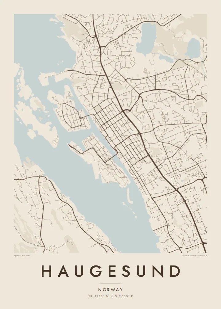
The narrow sound runs through the heart of Haugesund like a canal, with quays on both sides and bridges crossing to Risøy, giving the map a strong central axis.
Fakatino mape mukamuka · Norway
59.4138° N / 5.2680° E
A gridded harbour town on Norway's west coast, split by a narrow sound and fringed by islands and skerries.


Taha e taone, lima e onoonoaga
Tapaki e taha puhala ke kitia ai ki luga he puipui. Kua tatai e totogi he tau puhala oti — pete he lolomi, poloka, po ke faila HD.
 Tau pikselo mooli · faila lolomi 24 × 36″
Maama mitaki ke lolomi
Ko e 100% e fahi mooli mai he faila lolomi. Ko e tau poster oti — pete kua lolomi, poloka, po ke utu hifo — kua taute ke he ha mautolu a tau tokoluga (server) ke he 300 DPI, hokotia ke he 7,200 × 10,800 piksela, ke maeke ai e tau ala ikiiki tote ke maaliali fakamitaki he lolomi 24 × 36″.
He Pā


Ko e mape
Haugesund faces the North Sea on the Rogaland coast, sheltered behind a chain of islands. Its most distinctive feature from above is Smedasundet, the narrow strait that runs straight through the town and separates the mainland centre from Risøy and other islets. Quays line both sides of the water, and bridges stitch the two halves together.
The town grew quickly in the nineteenth century on the herring fisheries and was laid out with a regular grid of streets, unusual on a coast where most settlements follow the rock. North of the centre stands Haraldshaugen, the national monument raised in 1872 to Harald Fairhair, traditionally regarded as the king who united Norway. Each August the town hosts the Norwegian International Film Festival.
On a Haugesund map poster the contrast is striking. A tidy rectangle of streets fills the mainland, then a scatter of irregular islands, inlets and skerries breaks up into the sea. The coastline is so fragmented that the map becomes almost abstract at the edges, while the grid in the centre keeps it anchored and readable.
The narrow sound runs through the heart of Haugesund like a canal, with quays on both sides and bridges crossing to Risøy, giving the map a strong central axis.
Straight, evenly spaced streets fill the town centre, a planned pattern that sets Haugesund apart from the irregular fishing villages elsewhere along this rocky coast.
West of the town, dozens of small islands and reefs break up the shoreline, creating a lace of coastline that is especially graphic in black and white.
Taute ke ha hau
Lafi e aho, taha higoa po ke taha kupu haau, hiki e fakatino, lahi po ke tuaga.
Ko e kitiaaga nakai totogi kua tote e maaliali mo e fakamailoga vai. Ko e tau lolomi mo e tau faila HD kua taute ke he 300 DPI, hokotia ke he 7,200 × 10,800 px, nakai fai fakamailoga vai.
Ko e ha Haugesund
Haugesund draws people who have worked in the maritime and offshore industries, sailed along the west coast or come for the film festival. The mix of disciplined grid and wild coastline makes a map that reads well from across a room and still rewards a closer look.
Add your own title and subtitle, a date or the coordinates of a favourite quay, and choose Classic black & white, Noir, Paper, Blueprint or Sand. The digital files cost $9 for six print sizes, or you can order a matte printed poster with an optional wooden frame.
Talaage e poster Haugesund| Lahi he lolomi | Maama | Tau faila |
|---|---|---|
| 30 × 40 cm11.8 × 15.7″ | 3,543 × 4,724 px | PNG · PDF |
| 29.7 × 42 cm (A3)11.7 × 16.5″ | 3,508 × 4,961 px | PNG · PDF |
| 42 × 59.4 cm (A2)16.5 × 23.4″ | 4,961 × 7,016 px | PNG · PDF |
| 45.7 × 61 cm18 × 24″ | 5,400 × 7,200 px | PNG · PDF |
| 50 × 70 cm19.7 × 27.6″ | 5,906 × 8,268 px | PNG · PDF |
| 61 × 91.4 cm24 × 36″ | 7,200 × 10,800 px | PNG · PDF |
Ke fakatatai, ko e fakatino noa kua 900 px e laulahi, fai fakamailoga mo e mo e tau mata komipiuta ni. Ko e tau faila HD kua ato hoko ke he 8× e maama ke he tau faahi takitaha mo e lolomi mitaki he lahi katoa he fakatino.
Fifili e taha puhala i luga he kupega, ti fifili e Poster Lolomi — e lahi mo e, kaeke ke manako ai koe, taha poloka — po ke Tau Faila HD Fakaeletonika. Ko e fakaotiaga totogi ko e taha gahua ni, ti ko e kupega he hau a talaaga ka fakafou fakahaga i mua he fakaotiaga e totogi.
Kua lolomi ai ke he pepa mitaki 200 gsm matte he taha he tau lahi ono, mai he 30 × 40 cm ke hoko ke he 24 × 36″. Kamata e tau poster lolomi mai he $39, kua putoia ai e utaaga.
E. Fifili e poloka akau malolō ke he lanu uli, tea, akau oki mooli, po ke akau pouli. Kua fakalataha mo e sioga malolō nakai malepe ti kua mautali ke tautau. Kamata e tau poster poloka mai he $99, kua putoia ai e utaaga.
Nakai totogi e fakafano ke he motu 60+. Ko e fakatino taha kua lolomi he fenoga lolomi ha mautolu kua tata mo e tau motu 30+, kua hoko mai he tau aho gahua 3–7. Maeke ia koe ke kikite e tuaga mo e fakamuitua he lalo he Haku Tau Fakatonu. Ke he falu motu kua 2–5 e tau tapu, ti ka nakai fakafano a mautolu ki ai, to fakaha he api tupe ia ki mua he totogi.
Fakafano mai e taha ata ki a mautolu he loto he 14 e tau aho tali mai he hokoaga, ti to lolomi foki e mautolu nakai totogi po ke liu atu e totogi ki a koe.
E. He editor i luga he kupega nei, hikihiki e matakupu, e matakupu lalo mo e laini coordinates ke he taha mena kua manako a koe ki ai, ti fifili e puhala mo e lahi. Ko e tau talaaga lolomi, poloka mo e fakaeletonika oti kua fakaaoga tonu e hau a fakatino.
Ma e $9 ka moua e koe e tau faila PNG 300 DPI mo e PDF kua mautali ke lolomi he tau lahi ono oti, nakai fai fakamailoga vai, ke lolomi i fe mena. Nakai maopoopo agaia? Utu hifo fakamua e kitiaaga nakai totogi ne fai fakamailoga vai.
Tata mai
