Suomenlinna sea fortress
Built in the eighteenth century across several linked islands at the harbour entrance, its angular bastions and irregular walls form one of the most distinctive outlines on the whole map.
Fakatino mape mukamuka · Finland
60.1695° N / 24.9354° E
A granite peninsula that breaks into bays and islands, with a compact grid at its tip and sea on three sides


Taha e taone, lima e onoonoaga
Tapaki e taha puhala ke kitia ai ki luga he puipui. Kua tatai e totogi he tau puhala oti — pete he lolomi, poloka, po ke faila HD.
 Tau pikselo mooli · faila lolomi 24 × 36″
Maama mitaki ke lolomi
Ko e 100% e fahi mooli mai he faila lolomi. Ko e tau poster oti — pete kua lolomi, poloka, po ke utu hifo — kua taute ke he ha mautolu a tau tokoluga (server) ke he 300 DPI, hokotia ke he 7,200 × 10,800 piksela, ke maeke ai e tau ala ikiiki tote ke maaliali fakamitaki he lolomi 24 × 36″.
He Pā


Ko e mape
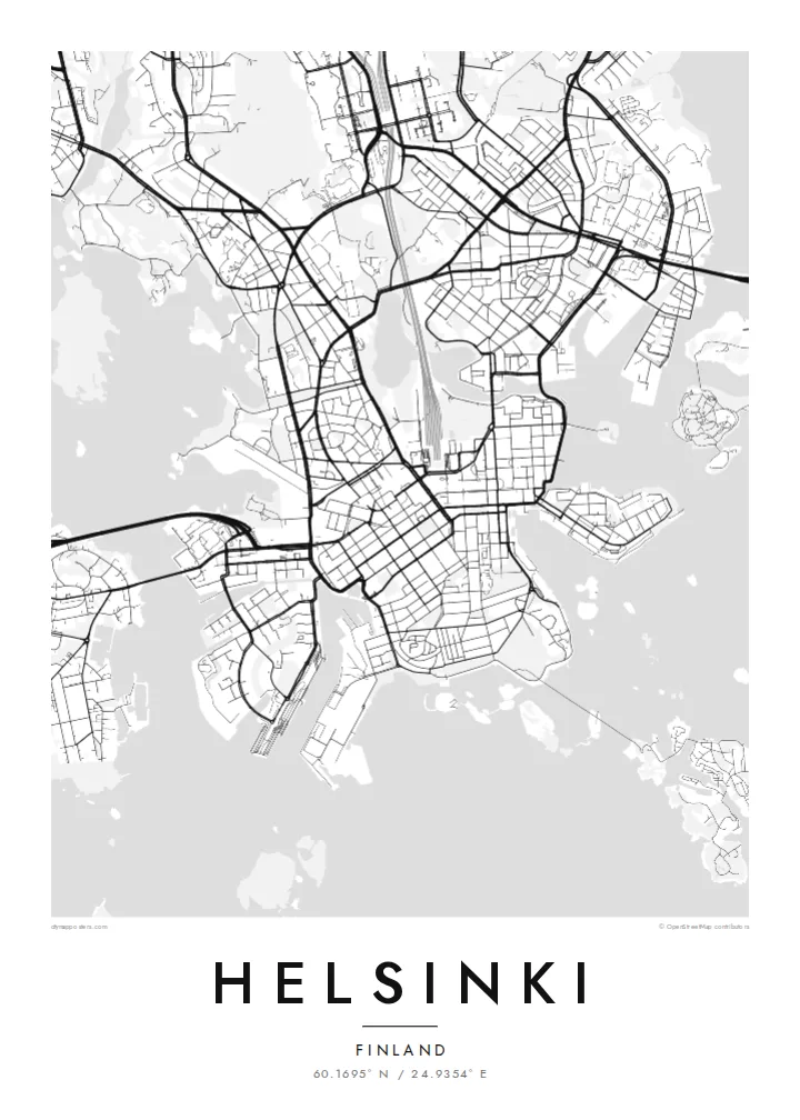
Helsinki sits on a peninsula that pushes into the Gulf of Finland, and from above its coastline matters most. The land breaks into coves, headlands and more than three hundred islands, so the city carries on past the point where the streets stop. Inland the pattern loosens into leafy districts and a long strip of forest, the Central Park, which runs north almost unbroken from Töölö Bay towards the city's edge.
The centre is orderly. After Helsinki was named capital in 1812, the architect Carl Ludvig Engel laid out a neoclassical core around Senate Square. The Esplanadi park strip still runs west from the market harbour as straight as a ruler. Around it, blocks of stone apartment buildings form a tight grid that reads cleanly in black and white. Rail yards and the long curve of the harbour break it up.
A Helsinki map poster shows this balance of order and irregularity: a precise centre, a coastline with almost no straight lines, and water in every gap. Offshore, the island fortress of Suomenlinna, a UNESCO World Heritage Site, spreads across a cluster of connected islets at the harbour mouth. Ferries, bridges and causeways join the rest together, and each one leaves a thin line on the page.
Built in the eighteenth century across several linked islands at the harbour entrance, its angular bastions and irregular walls form one of the most distinctive outlines on the whole map.
Senate Square and the Esplanadi park avenue sit just back from the South Harbour. They give the densest streets a clear, symmetrical anchor that stands out at every print size.
A band of forest about ten kilometres long runs north from the inner city. It leaves a wide, pale ribbon between the residential districts on either side.
Taute ke ha hau
Lafi e aho, taha higoa po ke taha kupu haau, hiki e fakatino, lahi po ke tuaga.
Ko e kitiaaga nakai totogi kua tote e maaliali mo e fakamailoga vai. Ko e tau lolomi mo e tau faila HD kua taute ke he 300 DPI, hokotia ke he 7,200 × 10,800 px, nakai fai fakamailoga vai.
Ko e ha Helsinki
People hang Helsinki for a flat near Töölö, summers on the islands, or an exchange year that turned into something longer. The map holds all of it at once: the harbour, the grid and the sea. Add a title, a date or a line of coordinates to mark which chapter it belongs to.
The coastline works especially well in Noir, where the water turns dark and the islands look like scattered light, or in Blueprint for a cooler, technical look. Classic black & white, Paper and Sand are available too. Download the HD files for $9 or order a matte print, framed if you like.
Talaage e poster Helsinki| Lahi he lolomi | Maama | Tau faila |
|---|---|---|
| 30 × 40 cm11.8 × 15.7″ | 3,543 × 4,724 px | PNG · PDF |
| 29.7 × 42 cm (A3)11.7 × 16.5″ | 3,508 × 4,961 px | PNG · PDF |
| 42 × 59.4 cm (A2)16.5 × 23.4″ | 4,961 × 7,016 px | PNG · PDF |
| 45.7 × 61 cm18 × 24″ | 5,400 × 7,200 px | PNG · PDF |
| 50 × 70 cm19.7 × 27.6″ | 5,906 × 8,268 px | PNG · PDF |
| 61 × 91.4 cm24 × 36″ | 7,200 × 10,800 px | PNG · PDF |
Ke fakatatai, ko e fakatino noa kua 900 px e laulahi, fai fakamailoga mo e mo e tau mata komipiuta ni. Ko e tau faila HD kua ato hoko ke he 8× e maama ke he tau faahi takitaha mo e lolomi mitaki he lahi katoa he fakatino.
Fifili e taha puhala i luga he kupega, ti fifili e Poster Lolomi — e lahi mo e, kaeke ke manako ai koe, taha poloka — po ke Tau Faila HD Fakaeletonika. Ko e fakaotiaga totogi ko e taha gahua ni, ti ko e kupega he hau a talaaga ka fakafou fakahaga i mua he fakaotiaga e totogi.
Kua lolomi ai ke he pepa mitaki 200 gsm matte he taha he tau lahi ono, mai he 30 × 40 cm ke hoko ke he 24 × 36″. Kamata e tau poster lolomi mai he $39, kua putoia ai e utaaga.
E. Fifili e poloka akau malolō ke he lanu uli, tea, akau oki mooli, po ke akau pouli. Kua fakalataha mo e sioga malolō nakai malepe ti kua mautali ke tautau. Kamata e tau poster poloka mai he $99, kua putoia ai e utaaga.
Nakai totogi e fakafano ke he motu 60+. Ko e fakatino taha kua lolomi he fenoga lolomi ha mautolu kua tata mo e tau motu 30+, kua hoko mai he tau aho gahua 3–7. Maeke ia koe ke kikite e tuaga mo e fakamuitua he lalo he Haku Tau Fakatonu. Ke he falu motu kua 2–5 e tau tapu, ti ka nakai fakafano a mautolu ki ai, to fakaha he api tupe ia ki mua he totogi.
Fakafano mai e taha ata ki a mautolu he loto he 14 e tau aho tali mai he hokoaga, ti to lolomi foki e mautolu nakai totogi po ke liu atu e totogi ki a koe.
E. He editor i luga he kupega nei, hikihiki e matakupu, e matakupu lalo mo e laini coordinates ke he taha mena kua manako a koe ki ai, ti fifili e puhala mo e lahi. Ko e tau talaaga lolomi, poloka mo e fakaeletonika oti kua fakaaoga tonu e hau a fakatino.
Ma e $9 ka moua e koe e tau faila PNG 300 DPI mo e PDF kua mautali ke lolomi he tau lahi ono oti, nakai fai fakamailoga vai, ke lolomi i fe mena. Nakai maopoopo agaia? Utu hifo fakamua e kitiaaga nakai totogi ne fai fakamailoga vai.
Tata mai
