Sullivans Cove
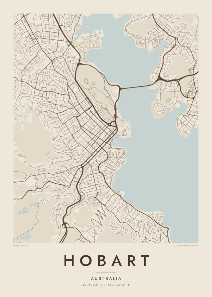
The harbour where Hobart began. On the map, its docks and wharves form a small, precise shape at the foot of the central grid, next to Salamanca Place and Battery Point.
Fakatino mape mukamuka · Australia
42.8794° S / 147.3294° E
Streets climbing from the Derwent estuary toward kunanyi, with a long bridge and a small historic harbour at the centre


Taha e taone, lima e onoonoaga
Tapaki e taha puhala ke kitia ai ki luga he puipui. Kua tatai e totogi he tau puhala oti — pete he lolomi, poloka, po ke faila HD.
 Tau pikselo mooli · faila lolomi 24 × 36″
Maama mitaki ke lolomi
Ko e 100% e fahi mooli mai he faila lolomi. Ko e tau poster oti — pete kua lolomi, poloka, po ke utu hifo — kua taute ke he ha mautolu a tau tokoluga (server) ke he 300 DPI, hokotia ke he 7,200 × 10,800 piksela, ke maeke ai e tau ala ikiiki tote ke maaliali fakamitaki he lolomi 24 × 36″.
He Pā


Ko e mape
Hobart occupies the western shore of the Derwent River estuary, below the mass of kunanyi / Mount Wellington, which rises to about 1,270 metres. From above, the city is squeezed into a band between water and mountain. Streets start at the harbour in a regular grid, then bend and thin out as they climb into the steep, wooded slopes behind.
Founded in 1804, Hobart is Australia's second-oldest capital city. The early town grew around Sullivans Cove, where Salamanca Place still keeps a row of sandstone warehouses, and the small streets of Battery Point climb the headland beside it. Across the estuary, the eastern shore is linked by the Tasman Bridge, a long, slender line on the map.
A Hobart map poster makes the geography unusually legible. The estuary opens wide to the south, the mountain leaves a large quiet space to the west, and the city fits between them. Suburbs follow the river north toward Glenorchy and beyond, while the headlands and bays along the shore give the edge of the map a detailed, irregular outline.
The harbour where Hobart began. On the map, its docks and wharves form a small, precise shape at the foot of the central grid, next to Salamanca Place and Battery Point.
A long bridge crossing the Derwent to the eastern shore. Its straight line over the wide estuary is one of the clearest single features of the whole composition.
The mountain west of the city leaves a broad area with few streets. Roads wind up toward it, and the grid fades into curving lines as the terrain steepens.
Taute ke ha hau
Lafi e aho, taha higoa po ke taha kupu haau, hiki e fakatino, lahi po ke tuaga.
Ko e kitiaaga nakai totogi kua tote e maaliali mo e fakamailoga vai. Ko e tau lolomi mo e tau faila HD kua taute ke he 300 DPI, hokotia ke he 7,200 × 10,800 px, nakai fai fakamailoga vai.
Ko e ha Hobart
Hobart tends to leave a strong impression, whether you grew up there, studied there or passed through on the way to the rest of Tasmania. The combination of water, mountain and small historic core is easy to recognise on a wall.
Add a title, a subtitle and the coordinates of a particular address or the city centre. Blueprint suits the estuary and harbour well, while Paper or Classic black & white keep the focus on the fine street pattern.
Talaage e poster Hobart| Lahi he lolomi | Maama | Tau faila |
|---|---|---|
| 30 × 40 cm11.8 × 15.7″ | 3,543 × 4,724 px | PNG · PDF |
| 29.7 × 42 cm (A3)11.7 × 16.5″ | 3,508 × 4,961 px | PNG · PDF |
| 42 × 59.4 cm (A2)16.5 × 23.4″ | 4,961 × 7,016 px | PNG · PDF |
| 45.7 × 61 cm18 × 24″ | 5,400 × 7,200 px | PNG · PDF |
| 50 × 70 cm19.7 × 27.6″ | 5,906 × 8,268 px | PNG · PDF |
| 61 × 91.4 cm24 × 36″ | 7,200 × 10,800 px | PNG · PDF |
Ke fakatatai, ko e fakatino noa kua 900 px e laulahi, fai fakamailoga mo e mo e tau mata komipiuta ni. Ko e tau faila HD kua ato hoko ke he 8× e maama ke he tau faahi takitaha mo e lolomi mitaki he lahi katoa he fakatino.
Fifili e taha puhala i luga he kupega, ti fifili e Poster Lolomi — e lahi mo e, kaeke ke manako ai koe, taha poloka — po ke Tau Faila HD Fakaeletonika. Ko e fakaotiaga totogi ko e taha gahua ni, ti ko e kupega he hau a talaaga ka fakafou fakahaga i mua he fakaotiaga e totogi.
Kua lolomi ai ke he pepa mitaki 200 gsm matte he taha he tau lahi ono, mai he 30 × 40 cm ke hoko ke he 24 × 36″. Kamata e tau poster lolomi mai he $39, kua putoia ai e utaaga.
E. Fifili e poloka akau malolō ke he lanu uli, tea, akau oki mooli, po ke akau pouli. Kua fakalataha mo e sioga malolō nakai malepe ti kua mautali ke tautau. Kamata e tau poster poloka mai he $99, kua putoia ai e utaaga.
Nakai totogi e fakafano ke he motu 60+. Ko e fakatino taha kua lolomi he fenoga lolomi ha mautolu kua tata mo e tau motu 30+, kua hoko mai he tau aho gahua 3–7. Maeke ia koe ke kikite e tuaga mo e fakamuitua he lalo he Haku Tau Fakatonu. Ke he falu motu kua 2–5 e tau tapu, ti ka nakai fakafano a mautolu ki ai, to fakaha he api tupe ia ki mua he totogi.
Fakafano mai e taha ata ki a mautolu he loto he 14 e tau aho tali mai he hokoaga, ti to lolomi foki e mautolu nakai totogi po ke liu atu e totogi ki a koe.
E. He editor i luga he kupega nei, hikihiki e matakupu, e matakupu lalo mo e laini coordinates ke he taha mena kua manako a koe ki ai, ti fifili e puhala mo e lahi. Ko e tau talaaga lolomi, poloka mo e fakaeletonika oti kua fakaaoga tonu e hau a fakatino.
Ma e $9 ka moua e koe e tau faila PNG 300 DPI mo e PDF kua mautali ke lolomi he tau lahi ono oti, nakai fai fakamailoga vai, ke lolomi i fe mena. Nakai maopoopo agaia? Utu hifo fakamua e kitiaaga nakai totogi ne fai fakamailoga vai.
Tata mai
