Doshisha campus
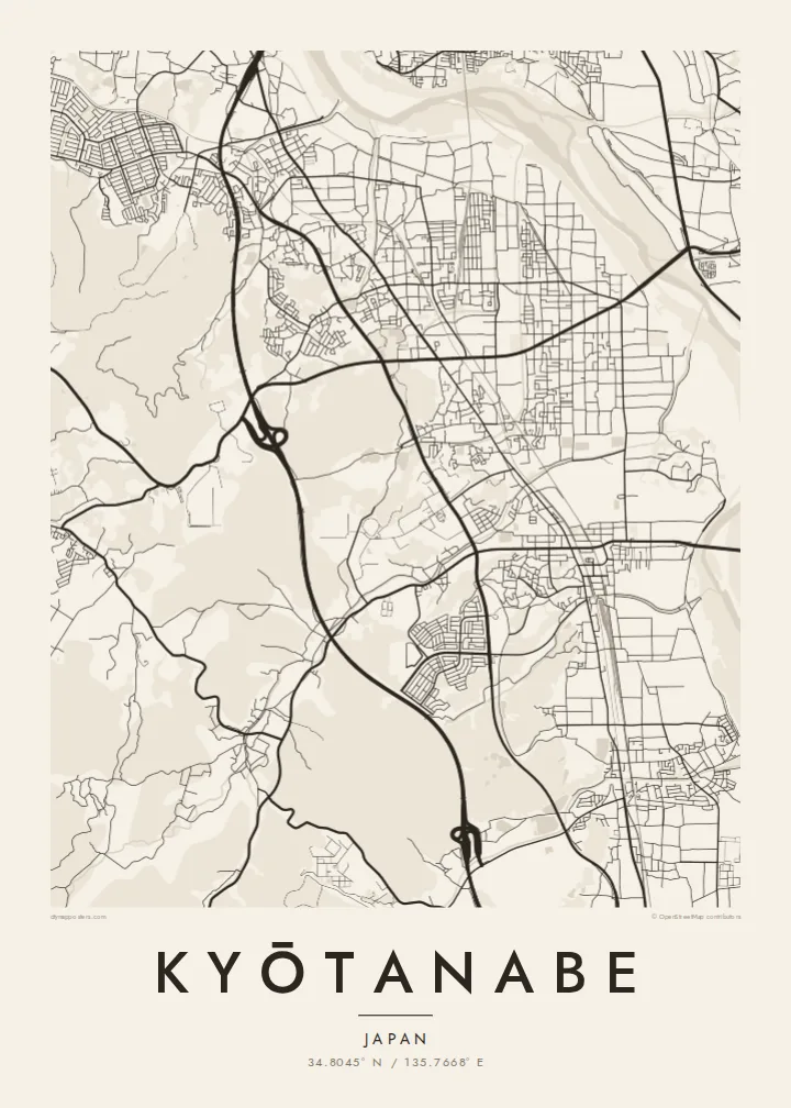
On the western hills, the university's Kyotanabe campus forms a large, clearly bounded area with its own internal roads and open spaces.
Fakatino mape mukamuka · Japan
34.8045° N / 135.7668° E
A long north–south town between Kyoto and Nara, shaped by parallel rail lines, the Kizu River and a hillside university campus.




Taha e taone, lima e onoonoaga
Tapaki e taha puhala ke kitia ai ki luga he puipui. Kua tatai e totogi he tau puhala oti — pete he lolomi, poloka, po ke faila HD.
 Tau pikselo mooli · faila lolomi 24 × 36″
Maama mitaki ke lolomi
Ko e 100% e fahi mooli mai he faila lolomi. Ko e tau poster oti — pete kua lolomi, poloka, po ke utu hifo — kua taute ke he ha mautolu a tau tokoluga (server) ke he 300 DPI, hokotia ke he 7,200 × 10,800 piksela, ke maeke ai e tau ala ikiiki tote ke maaliali fakamitaki he lolomi 24 × 36″.
He Pā


Ko e mape
Kyōtanabe stretches along the corridor between Kyoto and Nara, and its map is organised by lines running north to south. Two railways, the JR Gakkentoshi Line and the Kintetsu Kyoto Line, run through the town, and residential neighbourhoods have grown up around their stations. To the east, the Kizu River runs along the edge of the municipality, flanked by embankments and open ground.
To the west, the land rises into low hills, where the large Kyotanabe campus of Doshisha University occupies a broad area of paths and buildings. Between the hills and the river, housing estates, farmland and older village centres mix together, giving the map a varied texture. Tea is still grown in the surrounding area, part of the southern Kyoto tea-growing tradition.
The town is also home to Ikkyū-ji, the temple where the Zen monk Ikkyū spent his final years. A Kyōtanabe map poster captures the shape of a commuter town that still keeps traces of an older rural landscape, with rail, river and hills defining its outline more clearly than any single centre.
On the western hills, the university's Kyotanabe campus forms a large, clearly bounded area with its own internal roads and open spaces.
Along the eastern edge, the river and its embankments form a long, flowing line that sets the town's boundary against the neighbouring municipalities.
The temple associated with the monk Ikkyū sits in a quieter part of town, a small precinct set apart from the grid of newer neighbourhoods.
Taute ke ha hau
Lafi e aho, taha higoa po ke taha kupu haau, hiki e fakatino, lahi po ke tuaga.
Ko e kitiaaga nakai totogi kua tote e maaliali mo e fakamailoga vai. Ko e tau lolomi mo e tau faila HD kua taute ke he 300 DPI, hokotia ke he 7,200 × 10,800 px, nakai fai fakamailoga vai.
Ko e ha Kyōtanabe
For Doshisha students and graduates, Kyōtanabe is where years of study took place, and for residents it is a calm home between two historic cities. The map suits a graduation, a first apartment or a family house.
The title and subtitle can hold a name, a year or a station, and the coordinates line can be edited. Choose one of five styles; Classic black & white keeps the rail lines sharp, and Paper softens the whole plan.
Talaage e poster Kyōtanabe| Lahi he lolomi | Maama | Tau faila |
|---|---|---|
| 30 × 40 cm11.8 × 15.7″ | 3,543 × 4,724 px | PNG · PDF |
| 29.7 × 42 cm (A3)11.7 × 16.5″ | 3,508 × 4,961 px | PNG · PDF |
| 42 × 59.4 cm (A2)16.5 × 23.4″ | 4,961 × 7,016 px | PNG · PDF |
| 45.7 × 61 cm18 × 24″ | 5,400 × 7,200 px | PNG · PDF |
| 50 × 70 cm19.7 × 27.6″ | 5,906 × 8,268 px | PNG · PDF |
| 61 × 91.4 cm24 × 36″ | 7,200 × 10,800 px | PNG · PDF |
Ke fakatatai, ko e fakatino noa kua 900 px e laulahi, fai fakamailoga mo e mo e tau mata komipiuta ni. Ko e tau faila HD kua ato hoko ke he 8× e maama ke he tau faahi takitaha mo e lolomi mitaki he lahi katoa he fakatino.
Fifili e taha puhala i luga he kupega, ti fifili e Poster Lolomi — e lahi mo e, kaeke ke manako ai koe, taha poloka — po ke Tau Faila HD Fakaeletonika. Ko e fakaotiaga totogi ko e taha gahua ni, ti ko e kupega he hau a talaaga ka fakafou fakahaga i mua he fakaotiaga e totogi.
Kua lolomi ai ke he pepa mitaki 200 gsm matte he taha he tau lahi ono, mai he 30 × 40 cm ke hoko ke he 24 × 36″. Kamata e tau poster lolomi mai he $39, kua putoia ai e utaaga.
E. Fifili e poloka akau malolō ke he lanu uli, tea, akau oki mooli, po ke akau pouli. Kua fakalataha mo e sioga malolō nakai malepe ti kua mautali ke tautau. Kamata e tau poster poloka mai he $99, kua putoia ai e utaaga.
Nakai totogi e fakafano ke he motu 60+. Ko e fakatino taha kua lolomi he fenoga lolomi ha mautolu kua tata mo e tau motu 30+, kua hoko mai he tau aho gahua 3–7. Maeke ia koe ke kikite e tuaga mo e fakamuitua he lalo he Haku Tau Fakatonu. Ke he falu motu kua 2–5 e tau tapu, ti ka nakai fakafano a mautolu ki ai, to fakaha he api tupe ia ki mua he totogi.
Fakafano mai e taha ata ki a mautolu he loto he 14 e tau aho tali mai he hokoaga, ti to lolomi foki e mautolu nakai totogi po ke liu atu e totogi ki a koe.
E. He editor i luga he kupega nei, hikihiki e matakupu, e matakupu lalo mo e laini coordinates ke he taha mena kua manako a koe ki ai, ti fifili e puhala mo e lahi. Ko e tau talaaga lolomi, poloka mo e fakaeletonika oti kua fakaaoga tonu e hau a fakatino.
Ma e $9 ka moua e koe e tau faila PNG 300 DPI mo e PDF kua mautali ke lolomi he tau lahi ono oti, nakai fai fakamailoga vai, ke lolomi i fe mena. Nakai maopoopo agaia? Utu hifo fakamua e kitiaaga nakai totogi ne fai fakamailoga vai.
Tata mai
