Prairie grid
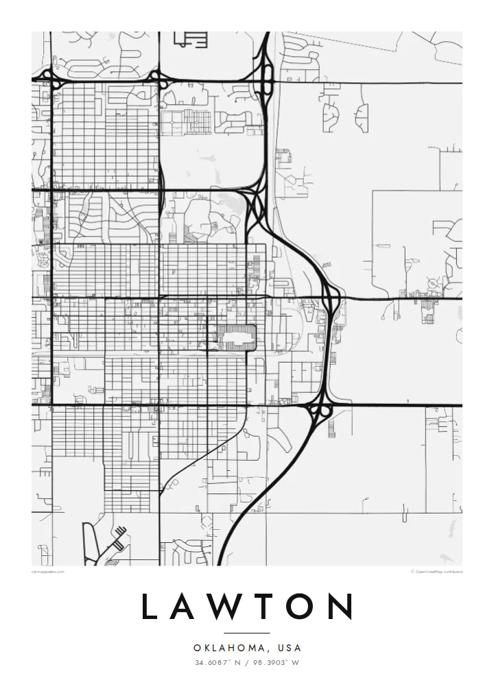
Numbered streets and avenues run north–south and east–west across flat land. They form one of the clearest and most regular urban grids in the southern Plains.
Fakatino mape mukamuka · United States
34.6087° N / 98.3903° W
A southwest Oklahoma city laid out on a prairie grid, beside Fort Sill and the rising Wichita Mountains.


Taha e taone, lima e onoonoaga
Tapaki e taha puhala ke kitia ai ki luga he puipui. Kua tatai e totogi he tau puhala oti — pete he lolomi, poloka, po ke faila HD.
 Tau pikselo mooli · faila lolomi 24 × 36″
Maama mitaki ke lolomi
Ko e 100% e fahi mooli mai he faila lolomi. Ko e tau poster oti — pete kua lolomi, poloka, po ke utu hifo — kua taute ke he ha mautolu a tau tokoluga (server) ke he 300 DPI, hokotia ke he 7,200 × 10,800 piksela, ke maeke ai e tau ala ikiiki tote ke maaliali fakamitaki he lolomi 24 × 36″.
He Pā


Ko e mape
Lawton was founded in 1901, when land from the former Kiowa, Comanche and Apache reservation was opened to settlement by lottery. The town was surveyed quickly on open prairie, and its map still reflects that origin. A clear grid of numbered streets and avenues, aligned to the compass, stretches out from the original town site.
Fort Sill, a large U.S. Army post established in 1869, lies directly north of the city and covers a large area on the map with its own roads, ranges and buildings. To the northwest the Wichita Mountains rise from the plains, home to a national wildlife refuge. Lakes and creeks add curved lines to the otherwise straight pattern.
A Lawton map poster sets a disciplined city grid against wide, open military land and the edge of the mountains. The contrast between the dense, regular streets and the sparse areas beyond gives the composition a strong structure. It is a meaningful piece for Army families who passed through Fort Sill and for people who grew up in the city itself.
Numbered streets and avenues run north–south and east–west across flat land. They form one of the clearest and most regular urban grids in the southern Plains.
The historic Army post occupies a large area north of the city. On the map it appears as a quieter zone with its own internal roads and wide open training ground.
To the northwest, the granite hills of the Wichita Mountains rise from the prairie. They add rugged, irregular ground and lakes at the edge of a wider composition.
Taute ke ha hau
Lafi e aho, taha higoa po ke taha kupu haau, hiki e fakatino, lahi po ke tuaga.
Ko e kitiaaga nakai totogi kua tote e maaliali mo e fakamailoga vai. Ko e tau lolomi mo e tau faila HD kua taute ke he 300 DPI, hokotia ke he 7,200 × 10,800 px, nakai fai fakamailoga vai.
Ko e ha Lawton
Lawton means a great deal to the many service members stationed at Fort Sill over the years, as well as to families with deep Comanche County roots. A map poster marks a posting, a hometown or a first house in a plain, lasting way.
Personalise the title, subtitle and coordinates line, perhaps with the years of a posting. Choose Classic black & white, Noir, Paper, Blueprint or Sand. Download HD files for $9, or order a matte printed poster with an optional wooden frame.
Talaage e poster Lawton| Lahi he lolomi | Maama | Tau faila |
|---|---|---|
| 30 × 40 cm11.8 × 15.7″ | 3,543 × 4,724 px | PNG · PDF |
| 29.7 × 42 cm (A3)11.7 × 16.5″ | 3,508 × 4,961 px | PNG · PDF |
| 42 × 59.4 cm (A2)16.5 × 23.4″ | 4,961 × 7,016 px | PNG · PDF |
| 45.7 × 61 cm18 × 24″ | 5,400 × 7,200 px | PNG · PDF |
| 50 × 70 cm19.7 × 27.6″ | 5,906 × 8,268 px | PNG · PDF |
| 61 × 91.4 cm24 × 36″ | 7,200 × 10,800 px | PNG · PDF |
Ke fakatatai, ko e fakatino noa kua 900 px e laulahi, fai fakamailoga mo e mo e tau mata komipiuta ni. Ko e tau faila HD kua ato hoko ke he 8× e maama ke he tau faahi takitaha mo e lolomi mitaki he lahi katoa he fakatino.
Fifili e taha puhala i luga he kupega, ti fifili e Poster Lolomi — e lahi mo e, kaeke ke manako ai koe, taha poloka — po ke Tau Faila HD Fakaeletonika. Ko e fakaotiaga totogi ko e taha gahua ni, ti ko e kupega he hau a talaaga ka fakafou fakahaga i mua he fakaotiaga e totogi.
Kua lolomi ai ke he pepa mitaki 200 gsm matte he taha he tau lahi ono, mai he 30 × 40 cm ke hoko ke he 24 × 36″. Kamata e tau poster lolomi mai he $39, kua putoia ai e utaaga.
E. Fifili e poloka akau malolō ke he lanu uli, tea, akau oki mooli, po ke akau pouli. Kua fakalataha mo e sioga malolō nakai malepe ti kua mautali ke tautau. Kamata e tau poster poloka mai he $99, kua putoia ai e utaaga.
Nakai totogi e fakafano ke he motu 60+. Ko e fakatino taha kua lolomi he fenoga lolomi ha mautolu kua tata mo e tau motu 30+, kua hoko mai he tau aho gahua 3–7. Maeke ia koe ke kikite e tuaga mo e fakamuitua he lalo he Haku Tau Fakatonu. Ke he falu motu kua 2–5 e tau tapu, ti ka nakai fakafano a mautolu ki ai, to fakaha he api tupe ia ki mua he totogi.
Fakafano mai e taha ata ki a mautolu he loto he 14 e tau aho tali mai he hokoaga, ti to lolomi foki e mautolu nakai totogi po ke liu atu e totogi ki a koe.
E. He editor i luga he kupega nei, hikihiki e matakupu, e matakupu lalo mo e laini coordinates ke he taha mena kua manako a koe ki ai, ti fifili e puhala mo e lahi. Ko e tau talaaga lolomi, poloka mo e fakaeletonika oti kua fakaaoga tonu e hau a fakatino.
Ma e $9 ka moua e koe e tau faila PNG 300 DPI mo e PDF kua mautali ke lolomi he tau lahi ono oti, nakai fai fakamailoga vai, ke lolomi i fe mena. Nakai maopoopo agaia? Utu hifo fakamua e kitiaaga nakai totogi ne fai fakamailoga vai.
