Yarlung Tsangpo
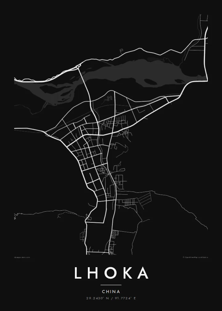
The river spreads across the valley in a network of shifting channels and islands. This braided pattern gives the map its most intricate and fluid lines.
Fakatino mape mukamuka · China
29.2430° N / 91.7724° E
A Tibetan prefecture seat in the Yarlung valley, where a small town grid meets the wide braided channels of the Yarlung Tsangpo.



Taha e taone, lima e onoonoaga
Tapaki e taha puhala ke kitia ai ki luga he puipui. Kua tatai e totogi he tau puhala oti — pete he lolomi, poloka, po ke faila HD.
 Tau pikselo mooli · faila lolomi 24 × 36″
Maama mitaki ke lolomi
Ko e 100% e fahi mooli mai he faila lolomi. Ko e tau poster oti — pete kua lolomi, poloka, po ke utu hifo — kua taute ke he ha mautolu a tau tokoluga (server) ke he 300 DPI, hokotia ke he 7,200 × 10,800 piksela, ke maeke ai e tau ala ikiiki tote ke maaliali fakamitaki he lolomi 24 × 36″.
He Pā


Ko e mape
Lhoka, known in Chinese as Shannan, is a prefecture-level city in southern Tibet. Its administrative centre, Tsetang, lies in the Yarlung Valley near where it meets the Yarlung Tsangpo. On a map the river is the dominant feature: a wide, braided course of channels and sandbanks. The town sits on the flat valley floor, and bare mountains rise steeply on either side.
The Yarlung Valley is traditionally seen as a cradle of Tibetan civilisation. According to Tibetan tradition, the first Tibetan kings came from here. The Yumbu Lakhang, a small fortress-palace on a ridge above the valley, is associated with them. Samye, considered the first Buddhist monastery in Tibet, stands on the north bank of the Yarlung Tsangpo within the prefecture.
The town itself is modest, with straight streets on level ground and newer districts extending along the valley. A Lhoka map poster shows the contrast between that orderly grid and the braided river. The empty space of the surrounding mountains presses in on both sides, giving the settled valley floor its narrow, elongated shape.
The river spreads across the valley in a network of shifting channels and islands. This braided pattern gives the map its most intricate and fluid lines.
The town's streets form a compact, mostly regular layout on the valley floor. Newer blocks extend along roads that follow the valley.
South of the town, the side valley of the Yarlung river leads up toward the Yumbu Lakhang. Fields and villages line its narrow floor between the mountains.
Taute ke ha hau
Lafi e aho, taha higoa po ke taha kupu haau, hiki e fakatino, lahi po ke tuaga.
Ko e kitiaaga nakai totogi kua tote e maaliali mo e fakamailoga vai. Ko e tau lolomi mo e tau faila HD kua taute ke he 300 DPI, hokotia ke he 7,200 × 10,800 px, nakai fai fakamailoga vai.
Ko e ha Lhoka
Travellers remember Lhoka for its high, clear light and deep history, and a map can hold a whole journey along the Yarlung valley in one frame. Add a title and a subtitle, mark a date, and use the coordinates of a town or monastery you visited.
Choose from Classic black and white, Noir, Paper, Blueprint and Sand. Blueprint and Noir give the braided river a crisp, graphic look. The $9 download includes six sizes as 300 DPI PNG and print-ready PDF files, with no watermark.
Talaage e poster Lhoka| Lahi he lolomi | Maama | Tau faila |
|---|---|---|
| 30 × 40 cm11.8 × 15.7″ | 3,543 × 4,724 px | PNG · PDF |
| 29.7 × 42 cm (A3)11.7 × 16.5″ | 3,508 × 4,961 px | PNG · PDF |
| 42 × 59.4 cm (A2)16.5 × 23.4″ | 4,961 × 7,016 px | PNG · PDF |
| 45.7 × 61 cm18 × 24″ | 5,400 × 7,200 px | PNG · PDF |
| 50 × 70 cm19.7 × 27.6″ | 5,906 × 8,268 px | PNG · PDF |
| 61 × 91.4 cm24 × 36″ | 7,200 × 10,800 px | PNG · PDF |
Ke fakatatai, ko e fakatino noa kua 900 px e laulahi, fai fakamailoga mo e mo e tau mata komipiuta ni. Ko e tau faila HD kua ato hoko ke he 8× e maama ke he tau faahi takitaha mo e lolomi mitaki he lahi katoa he fakatino.
Fifili e taha puhala i luga he kupega, ti fifili e Poster Lolomi — e lahi mo e, kaeke ke manako ai koe, taha poloka — po ke Tau Faila HD Fakaeletonika. Ko e fakaotiaga totogi ko e taha gahua ni, ti ko e kupega he hau a talaaga ka fakafou fakahaga i mua he fakaotiaga e totogi.
Kua lolomi ai ke he pepa mitaki 200 gsm matte he taha he tau lahi ono, mai he 30 × 40 cm ke hoko ke he 24 × 36″. Kamata e tau poster lolomi mai he $39, kua putoia ai e utaaga.
E. Fifili e poloka akau malolō ke he lanu uli, tea, akau oki mooli, po ke akau pouli. Kua fakalataha mo e sioga malolō nakai malepe ti kua mautali ke tautau. Kamata e tau poster poloka mai he $99, kua putoia ai e utaaga.
Nakai totogi e fakafano ke he motu 60+. Ko e fakatino taha kua lolomi he fenoga lolomi ha mautolu kua tata mo e tau motu 30+, kua hoko mai he tau aho gahua 3–7. Maeke ia koe ke kikite e tuaga mo e fakamuitua he lalo he Haku Tau Fakatonu. Ke he falu motu kua 2–5 e tau tapu, ti ka nakai fakafano a mautolu ki ai, to fakaha he api tupe ia ki mua he totogi.
Fakafano mai e taha ata ki a mautolu he loto he 14 e tau aho tali mai he hokoaga, ti to lolomi foki e mautolu nakai totogi po ke liu atu e totogi ki a koe.
E. He editor i luga he kupega nei, hikihiki e matakupu, e matakupu lalo mo e laini coordinates ke he taha mena kua manako a koe ki ai, ti fifili e puhala mo e lahi. Ko e tau talaaga lolomi, poloka mo e fakaeletonika oti kua fakaaoga tonu e hau a fakatino.
Ma e $9 ka moua e koe e tau faila PNG 300 DPI mo e PDF kua mautali ke lolomi he tau lahi ono oti, nakai fai fakamailoga vai, ke lolomi i fe mena. Nakai maopoopo agaia? Utu hifo fakamua e kitiaaga nakai totogi ne fai fakamailoga vai.
Tata mai
