Valley floor
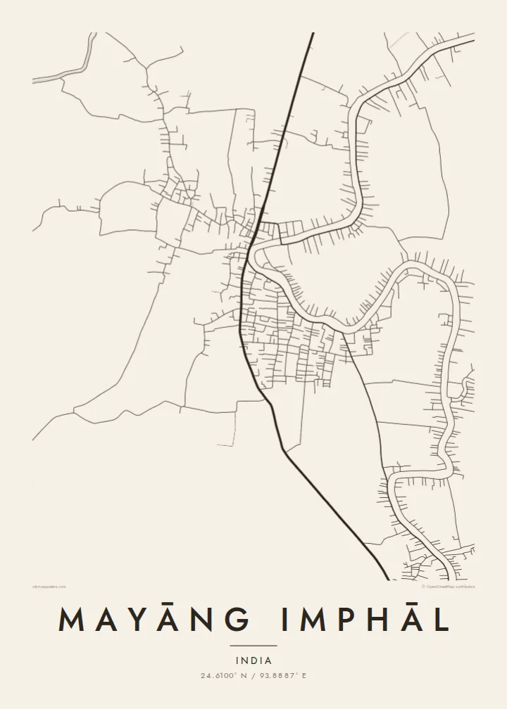
The town sits on the level floor of the Imphal Valley. Its roads spread out easily across the land, without the tight bends that hill terrain forces on towns higher up in Manipur.
Fakatino mape mukamuka · India
24.6100° N / 93.8887° E
A low valley town among paddy fields southwest of Imphal, its roads loose and branching across the flat floor of the Manipur basin.




Taha e taone, lima e onoonoaga
Tapaki e taha puhala ke kitia ai ki luga he puipui. Kua tatai e totogi he tau puhala oti — pete he lolomi, poloka, po ke faila HD.
 Tau pikselo mooli · faila lolomi 24 × 36″
Maama mitaki ke lolomi
Ko e 100% e fahi mooli mai he faila lolomi. Ko e tau poster oti — pete kua lolomi, poloka, po ke utu hifo — kua taute ke he ha mautolu a tau tokoluga (server) ke he 300 DPI, hokotia ke he 7,200 × 10,800 piksela, ke maeke ai e tau ala ikiiki tote ke maaliali fakamitaki he lolomi 24 × 36″.
He Pā


Ko e mape
Mayāng Imphāl lies on the floor of the Imphal Valley, the broad oval basin at the heart of Manipur, southwest of the state capital. On a map the ground reads as open and level. Roads branch across farmland, water channels cross the fields, and houses gather along the lanes instead of forming a dense core. Hills rise on every side of the valley, so the flat centre stands out clearly.
The town grew as a local market and administrative centre for the surrounding villages. In fine black line the street network looks relaxed: a few main roads carry the traffic, and smaller paths run off them into the settlements. Ponds and field boundaries fill the gaps, so the valley's farming economy shows up as pattern alone, with no labels needed.
A Mayāng Imphāl map poster works best at a scale that includes the fields around the town. The edges then show how the built-up area thins into cultivated land, and the valley setting becomes the subject as much as the streets. The result is quiet and spacious, with a lot of breathing room between lines.
The town sits on the level floor of the Imphal Valley. Its roads spread out easily across the land, without the tight bends that hill terrain forces on towns higher up in Manipur.
Around the houses, paddy fields and small ponds break the map into irregular parcels. The open spaces between the lines show how much of the area is still farmed.
The main roads run northeast toward Imphal and out to neighbouring villages. They give the composition a clear axis and link the town to the rest of the valley.
Taute ke ha hau
Lafi e aho, taha higoa po ke taha kupu haau, hiki e fakatino, lahi po ke tuaga.
Ko e kitiaaga nakai totogi kua tote e maaliali mo e fakamailoga vai. Ko e tau lolomi mo e tau faila HD kua taute ke he 300 DPI, hokotia ke he 7,200 × 10,800 px, nakai fai fakamailoga vai.
Ko e ha Mayāng Imphāl
People who grew up in the Imphal Valley, or who have family there, often want a picture of a place that rarely shows up in print. A map of home keeps its lanes and fields in view, however far away you now live.
You can set the title in any spelling you like, add a family name or a meaningful date in the subtitle, and choose from Classic black & white, Noir, Paper, Blueprint and Sand. The HD files cost $9, or you can order a matte print with an optional wooden frame.
Talaage e poster Mayāng Imphāl| Lahi he lolomi | Maama | Tau faila |
|---|---|---|
| 30 × 40 cm11.8 × 15.7″ | 3,543 × 4,724 px | PNG · PDF |
| 29.7 × 42 cm (A3)11.7 × 16.5″ | 3,508 × 4,961 px | PNG · PDF |
| 42 × 59.4 cm (A2)16.5 × 23.4″ | 4,961 × 7,016 px | PNG · PDF |
| 45.7 × 61 cm18 × 24″ | 5,400 × 7,200 px | PNG · PDF |
| 50 × 70 cm19.7 × 27.6″ | 5,906 × 8,268 px | PNG · PDF |
| 61 × 91.4 cm24 × 36″ | 7,200 × 10,800 px | PNG · PDF |
Ke fakatatai, ko e fakatino noa kua 900 px e laulahi, fai fakamailoga mo e mo e tau mata komipiuta ni. Ko e tau faila HD kua ato hoko ke he 8× e maama ke he tau faahi takitaha mo e lolomi mitaki he lahi katoa he fakatino.
Fifili e taha puhala i luga he kupega, ti fifili e Poster Lolomi — e lahi mo e, kaeke ke manako ai koe, taha poloka — po ke Tau Faila HD Fakaeletonika. Ko e fakaotiaga totogi ko e taha gahua ni, ti ko e kupega he hau a talaaga ka fakafou fakahaga i mua he fakaotiaga e totogi.
Kua lolomi ai ke he pepa mitaki 200 gsm matte he taha he tau lahi ono, mai he 30 × 40 cm ke hoko ke he 24 × 36″. Kamata e tau poster lolomi mai he $39, kua putoia ai e utaaga.
E. Fifili e poloka akau malolō ke he lanu uli, tea, akau oki mooli, po ke akau pouli. Kua fakalataha mo e sioga malolō nakai malepe ti kua mautali ke tautau. Kamata e tau poster poloka mai he $99, kua putoia ai e utaaga.
Nakai totogi e fakafano ke he motu 60+. Ko e fakatino taha kua lolomi he fenoga lolomi ha mautolu kua tata mo e tau motu 30+, kua hoko mai he tau aho gahua 3–7. Maeke ia koe ke kikite e tuaga mo e fakamuitua he lalo he Haku Tau Fakatonu. Ke he falu motu kua 2–5 e tau tapu, ti ka nakai fakafano a mautolu ki ai, to fakaha he api tupe ia ki mua he totogi.
Fakafano mai e taha ata ki a mautolu he loto he 14 e tau aho tali mai he hokoaga, ti to lolomi foki e mautolu nakai totogi po ke liu atu e totogi ki a koe.
E. He editor i luga he kupega nei, hikihiki e matakupu, e matakupu lalo mo e laini coordinates ke he taha mena kua manako a koe ki ai, ti fifili e puhala mo e lahi. Ko e tau talaaga lolomi, poloka mo e fakaeletonika oti kua fakaaoga tonu e hau a fakatino.
Ma e $9 ka moua e koe e tau faila PNG 300 DPI mo e PDF kua mautali ke lolomi he tau lahi ono oti, nakai fai fakamailoga vai, ke lolomi i fe mena. Nakai maopoopo agaia? Utu hifo fakamua e kitiaaga nakai totogi ne fai fakamailoga vai.
Tata mai
