Natori River mouth
The river reaches the Pacific at Yuriage. Its final bend and the rebuilt harbour district form the most detailed part of the coastline on the map.
Fakatino mape mukamuka · Japan
38.1667° N / 140.8833° E
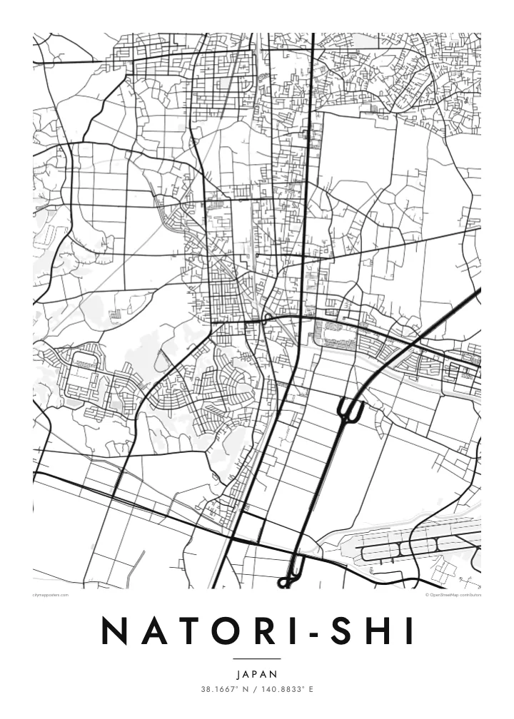
A flat coastal city south of Sendai, stretching from inland neighbourhoods across rice fields to the port of Yuriage on the Pacific.
Taha e taone, lima e onoonoaga
Tapaki e taha puhala ke kitia ai ki luga he puipui. Kua tatai e totogi he tau puhala oti — pete he lolomi, poloka, po ke faila HD.
 Tau pikselo mooli · faila lolomi 24 × 36″
Maama mitaki ke lolomi
Ko e 100% e fahi mooli mai he faila lolomi. Ko e tau poster oti — pete kua lolomi, poloka, po ke utu hifo — kua taute ke he ha mautolu a tau tokoluga (server) ke he 300 DPI, hokotia ke he 7,200 × 10,800 piksela, ke maeke ai e tau ala ikiiki tote ke maaliali fakamitaki he lolomi 24 × 36″.
He Pā


Ko e mape
Natori lies directly south of Sendai in Miyagi Prefecture, on the broad coastal plain along Sendai Bay. The Natori River forms much of its boundary with Sendai. On a map the city reads as a band of land stretching from low hills and suburbs in the west, across farmland, to a straight Pacific shoreline in the east.
The coastal district of Yuriage, at the mouth of the river, was devastated by the tsunami of March 2011 and has since been rebuilt on raised ground. Sendai Airport lies at the city's southern edge, shared with neighbouring Iwanuma, its runway a clean straight line near the coast. Rail and road links have made Natori a commuter city for Sendai.
A Natori-shi map poster captures a place defined by its plain: rectangular paddy fields, a river winding to the sea, a straight coastline and a runway. For people with family roots in Yuriage, or memories of the coast before and after 2011, it can be a deeply personal piece to hang at home.
The river reaches the Pacific at Yuriage. Its final bend and the rebuilt harbour district form the most detailed part of the coastline on the map.
The airport sits on the coastal plain at the city's southern edge. Its long runway is a crisp geometric line among the fields.
Between the town centre and the sea, rice fields in regular rectangles cover the land. They give the eastern half of the poster a quiet, even texture.
Taute ke ha hau
Lafi e aho, taha higoa po ke taha kupu haau, hiki e fakatino, lahi po ke tuaga.
Ko e kitiaaga nakai totogi kua tote e maaliali mo e fakamailoga vai. Ko e tau lolomi mo e tau faila HD kua taute ke he 300 DPI, hokotia ke he 7,200 × 10,800 px, nakai fai fakamailoga vai.
Ko e ha Natori-shi
Natori is home to many who commute to Sendai, and to families who have lived on the coast for generations. A map of the city holds both the newer neighbourhoods and the rebuilt shoreline in one quiet frame.
Choose a title and subtitle, perhaps the name of a district and a date, and edit the coordinates. Five styles are available, from Classic black & white to Sand. Download 300 DPI PNG and PDF files in six sizes for $9.
Talaage e poster Natori-shi| Lahi he lolomi | Maama | Tau faila |
|---|---|---|
| 30 × 40 cm11.8 × 15.7″ | 3,543 × 4,724 px | PNG · PDF |
| 29.7 × 42 cm (A3)11.7 × 16.5″ | 3,508 × 4,961 px | PNG · PDF |
| 42 × 59.4 cm (A2)16.5 × 23.4″ | 4,961 × 7,016 px | PNG · PDF |
| 45.7 × 61 cm18 × 24″ | 5,400 × 7,200 px | PNG · PDF |
| 50 × 70 cm19.7 × 27.6″ | 5,906 × 8,268 px | PNG · PDF |
| 61 × 91.4 cm24 × 36″ | 7,200 × 10,800 px | PNG · PDF |
Ke fakatatai, ko e fakatino noa kua 900 px e laulahi, fai fakamailoga mo e mo e tau mata komipiuta ni. Ko e tau faila HD kua ato hoko ke he 8× e maama ke he tau faahi takitaha mo e lolomi mitaki he lahi katoa he fakatino.
Fifili e taha puhala i luga he kupega, ti fifili e Poster Lolomi — e lahi mo e, kaeke ke manako ai koe, taha poloka — po ke Tau Faila HD Fakaeletonika. Ko e fakaotiaga totogi ko e taha gahua ni, ti ko e kupega he hau a talaaga ka fakafou fakahaga i mua he fakaotiaga e totogi.
Kua lolomi ai ke he pepa mitaki 200 gsm matte he taha he tau lahi ono, mai he 30 × 40 cm ke hoko ke he 24 × 36″. Kamata e tau poster lolomi mai he $39, kua putoia ai e utaaga.
E. Fifili e poloka akau malolō ke he lanu uli, tea, akau oki mooli, po ke akau pouli. Kua fakalataha mo e sioga malolō nakai malepe ti kua mautali ke tautau. Kamata e tau poster poloka mai he $99, kua putoia ai e utaaga.
Nakai totogi e fakafano ke he motu 60+. Ko e fakatino taha kua lolomi he fenoga lolomi ha mautolu kua tata mo e tau motu 30+, kua hoko mai he tau aho gahua 3–7. Maeke ia koe ke kikite e tuaga mo e fakamuitua he lalo he Haku Tau Fakatonu. Ke he falu motu kua 2–5 e tau tapu, ti ka nakai fakafano a mautolu ki ai, to fakaha he api tupe ia ki mua he totogi.
Fakafano mai e taha ata ki a mautolu he loto he 14 e tau aho tali mai he hokoaga, ti to lolomi foki e mautolu nakai totogi po ke liu atu e totogi ki a koe.
E. He editor i luga he kupega nei, hikihiki e matakupu, e matakupu lalo mo e laini coordinates ke he taha mena kua manako a koe ki ai, ti fifili e puhala mo e lahi. Ko e tau talaaga lolomi, poloka mo e fakaeletonika oti kua fakaaoga tonu e hau a fakatino.
Ma e $9 ka moua e koe e tau faila PNG 300 DPI mo e PDF kua mautali ke lolomi he tau lahi ono oti, nakai fai fakamailoga vai, ke lolomi i fe mena. Nakai maopoopo agaia? Utu hifo fakamua e kitiaaga nakai totogi ne fai fakamailoga vai.
Tata mai
