The fish quay
A cluster of jetties, sheds and moorings on the riverbank, where the town's long fishing tradition still shapes the shoreline into a dense, irregular edge of short piers.
Fakatino mape mukamuka · United Kingdom
55.0165° N / 1.4492° W
A riverside town on the north bank of the Tyne, where quays and a planned upper grid face the estuary mouth




Taha e taone, lima e onoonoaga
Tapaki e taha puhala ke kitia ai ki luga he puipui. Kua tatai e totogi he tau puhala oti — pete he lolomi, poloka, po ke faila HD.
 Tau pikselo mooli · faila lolomi 24 × 36″
Maama mitaki ke lolomi
Ko e 100% e fahi mooli mai he faila lolomi. Ko e tau poster oti — pete kua lolomi, poloka, po ke utu hifo — kua taute ke he ha mautolu a tau tokoluga (server) ke he 300 DPI, hokotia ke he 7,200 × 10,800 piksela, ke maeke ai e tau ala ikiiki tote ke maaliali fakamitaki he lolomi 24 × 36″.
He Pā


Ko e mape
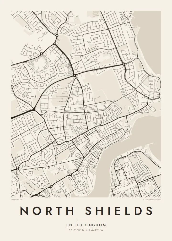
North Shields sits on the north bank of the River Tyne, close to where the estuary opens into the North Sea. From above, the town splits into two levels: a tight strip of streets and quays along the water, and a more regular upper town laid out on the bank above it. Steps and steep lanes link the two, and on a map they show as short, abrupt connectors.
The fish quay remains the town's best-known edge, a working waterfront of sheds, jetties and moorings that gives the shoreline a jagged, busy outline. Further upriver the Royal Quays area turns former dock land into marina basins and the terminal for ferries across the North Sea. Across the water lies South Shields, linked by a small passenger ferry, so the river works as a street rather than a border.
A North Shields map poster captures that contrast between the irregular riverbank and the orderly terraces above it. The Tyne takes up a broad band of the frame, its curves leading the eye towards the harbour piers at the river mouth. Inland, rows of terraced housing fill the upper part of the sheet with fine, parallel lines, so the town reads as layered and closely tied to the sea.
A cluster of jetties, sheds and moorings on the riverbank, where the town's long fishing tradition still shapes the shoreline into a dense, irregular edge of short piers.
A steep bank separates the old waterside streets from the planned town above, and on the map the change shows as a sudden switch from crooked lanes to straight terraces.
A short passenger ferry crosses to South Shields, and the river itself becomes the widest open space on the map, framed by quays on both banks.
Taute ke ha hau
Lafi e aho, taha higoa po ke taha kupu haau, hiki e fakatino, lahi po ke tuaga.
Ko e kitiaaga nakai totogi kua tote e maaliali mo e fakamailoga vai. Ko e tau lolomi mo e tau faila HD kua taute ke he 300 DPI, hokotia ke he 7,200 × 10,800 px, nakai fai fakamailoga vai.
Ko e ha North Shields
For people who grew up on Tyneside, worked on the river or crossed on the ferry, the map traces a place defined by water and weather. It is a quiet reminder of the quay, the bank and the way the town faces the sea.
You can personalise the title, subtitle and coordinates line, adding a family name or a date that matters. Choose from Classic black & white, Noir, Paper, Blueprint or Sand, and order a printed poster or download the $9 HD files.
Talaage e poster North Shields| Lahi he lolomi | Maama | Tau faila |
|---|---|---|
| 30 × 40 cm11.8 × 15.7″ | 3,543 × 4,724 px | PNG · PDF |
| 29.7 × 42 cm (A3)11.7 × 16.5″ | 3,508 × 4,961 px | PNG · PDF |
| 42 × 59.4 cm (A2)16.5 × 23.4″ | 4,961 × 7,016 px | PNG · PDF |
| 45.7 × 61 cm18 × 24″ | 5,400 × 7,200 px | PNG · PDF |
| 50 × 70 cm19.7 × 27.6″ | 5,906 × 8,268 px | PNG · PDF |
| 61 × 91.4 cm24 × 36″ | 7,200 × 10,800 px | PNG · PDF |
Ke fakatatai, ko e fakatino noa kua 900 px e laulahi, fai fakamailoga mo e mo e tau mata komipiuta ni. Ko e tau faila HD kua ato hoko ke he 8× e maama ke he tau faahi takitaha mo e lolomi mitaki he lahi katoa he fakatino.
Fifili e taha puhala i luga he kupega, ti fifili e Poster Lolomi — e lahi mo e, kaeke ke manako ai koe, taha poloka — po ke Tau Faila HD Fakaeletonika. Ko e fakaotiaga totogi ko e taha gahua ni, ti ko e kupega he hau a talaaga ka fakafou fakahaga i mua he fakaotiaga e totogi.
Kua lolomi ai ke he pepa mitaki 200 gsm matte he taha he tau lahi ono, mai he 30 × 40 cm ke hoko ke he 24 × 36″. Kamata e tau poster lolomi mai he $39, kua putoia ai e utaaga.
E. Fifili e poloka akau malolō ke he lanu uli, tea, akau oki mooli, po ke akau pouli. Kua fakalataha mo e sioga malolō nakai malepe ti kua mautali ke tautau. Kamata e tau poster poloka mai he $99, kua putoia ai e utaaga.
Nakai totogi e fakafano ke he motu 60+. Ko e fakatino taha kua lolomi he fenoga lolomi ha mautolu kua tata mo e tau motu 30+, kua hoko mai he tau aho gahua 3–7. Maeke ia koe ke kikite e tuaga mo e fakamuitua he lalo he Haku Tau Fakatonu. Ke he falu motu kua 2–5 e tau tapu, ti ka nakai fakafano a mautolu ki ai, to fakaha he api tupe ia ki mua he totogi.
Fakafano mai e taha ata ki a mautolu he loto he 14 e tau aho tali mai he hokoaga, ti to lolomi foki e mautolu nakai totogi po ke liu atu e totogi ki a koe.
E. He editor i luga he kupega nei, hikihiki e matakupu, e matakupu lalo mo e laini coordinates ke he taha mena kua manako a koe ki ai, ti fifili e puhala mo e lahi. Ko e tau talaaga lolomi, poloka mo e fakaeletonika oti kua fakaaoga tonu e hau a fakatino.
Ma e $9 ka moua e koe e tau faila PNG 300 DPI mo e PDF kua mautali ke lolomi he tau lahi ono oti, nakai fai fakamailoga vai, ke lolomi i fe mena. Nakai maopoopo agaia? Utu hifo fakamua e kitiaaga nakai totogi ne fai fakamailoga vai.
Tata mai
