Funai Castle
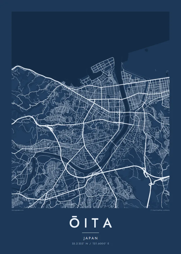
The castle ruins in the centre, with moats and stone walls, form a clear square. The surrounding streets are laid out in an orderly grid around it.
Fakatino mape mukamuka · Japan
33.2333° N / 131.6000° E
A bayside city on Kyushu where two rivers reach the sea, with castle moats at the centre and industry along the shore



Taha e taone, lima e onoonoaga
Tapaki e taha puhala ke kitia ai ki luga he puipui. Kua tatai e totogi he tau puhala oti — pete he lolomi, poloka, po ke faila HD.
 Tau pikselo mooli · faila lolomi 24 × 36″
Maama mitaki ke lolomi
Ko e 100% e fahi mooli mai he faila lolomi. Ko e tau poster oti — pete kua lolomi, poloka, po ke utu hifo — kua taute ke he ha mautolu a tau tokoluga (server) ke he 300 DPI, hokotia ke he 7,200 × 10,800 piksela, ke maeke ai e tau ala ikiiki tote ke maaliali fakamitaki he lolomi 24 × 36″.
He Pā


Ko e mape
Ōita lies on the northern coast of Kyushu, facing Beppu Bay, and its map is shaped by two rivers, the Ōita and the Ōno, which reach the sea on either side of the city. Between them, the centre is laid out in a regular grid around the remains of Funai Castle, whose moats and stone walls still form a clear square in the street pattern. Much of the coastline has been reclaimed for industry.
In the sixteenth century the area was ruled by the Ōtomo clan, and under Ōtomo Sōrin the town of Funai became one of Japan's early points of contact with Europe. Francis Xavier visited in 1551. Today Ōita is the prefectural capital, and it sits right next to Beppu, one of Japan's best-known hot spring towns.
An Ōita map poster brings together the grid of the castle town, the two river mouths and the straight edges of the reclaimed coast. The hills behind the city frame it on the landward side. In black and white the castle's square moats, the river curves and the man-made shoreline create a composition that feels both historical and modern.
The castle ruins in the centre, with moats and stone walls, form a clear square. The surrounding streets are laid out in an orderly grid around it.
The Ōita and Ōno rivers enter Beppu Bay on either side of the city, framing the urban area with long, curving lines of water.
Large areas of the shore were filled in for industry. On the map they appear as straight-edged blocks pushing into the bay.
Taute ke ha hau
Lafi e aho, taha higoa po ke taha kupu haau, hiki e fakatino, lahi po ke tuaga.
Ko e kitiaaga nakai totogi kua tote e maaliali mo e fakamailoga vai. Ko e tau lolomi mo e tau faila HD kua taute ke he 300 DPI, hokotia ke he 7,200 × 10,800 px, nakai fai fakamailoga vai.
Ko e ha Ōita
Ōita is a map for people from Kyushu, for those who have lived in the prefecture, and for travellers who remember the bay and the nearby hot springs. The castle square and the rivers make it easy to recognise.
Personalise the title, subtitle and coordinates line with a date or phrase, and choose Classic black & white, Noir, Paper, Blueprint or Sand. Blueprint suits the bay and the industrial coast.
Talaage e poster Ōita| Lahi he lolomi | Maama | Tau faila |
|---|---|---|
| 30 × 40 cm11.8 × 15.7″ | 3,543 × 4,724 px | PNG · PDF |
| 29.7 × 42 cm (A3)11.7 × 16.5″ | 3,508 × 4,961 px | PNG · PDF |
| 42 × 59.4 cm (A2)16.5 × 23.4″ | 4,961 × 7,016 px | PNG · PDF |
| 45.7 × 61 cm18 × 24″ | 5,400 × 7,200 px | PNG · PDF |
| 50 × 70 cm19.7 × 27.6″ | 5,906 × 8,268 px | PNG · PDF |
| 61 × 91.4 cm24 × 36″ | 7,200 × 10,800 px | PNG · PDF |
Ke fakatatai, ko e fakatino noa kua 900 px e laulahi, fai fakamailoga mo e mo e tau mata komipiuta ni. Ko e tau faila HD kua ato hoko ke he 8× e maama ke he tau faahi takitaha mo e lolomi mitaki he lahi katoa he fakatino.
Fifili e taha puhala i luga he kupega, ti fifili e Poster Lolomi — e lahi mo e, kaeke ke manako ai koe, taha poloka — po ke Tau Faila HD Fakaeletonika. Ko e fakaotiaga totogi ko e taha gahua ni, ti ko e kupega he hau a talaaga ka fakafou fakahaga i mua he fakaotiaga e totogi.
Kua lolomi ai ke he pepa mitaki 200 gsm matte he taha he tau lahi ono, mai he 30 × 40 cm ke hoko ke he 24 × 36″. Kamata e tau poster lolomi mai he $39, kua putoia ai e utaaga.
E. Fifili e poloka akau malolō ke he lanu uli, tea, akau oki mooli, po ke akau pouli. Kua fakalataha mo e sioga malolō nakai malepe ti kua mautali ke tautau. Kamata e tau poster poloka mai he $99, kua putoia ai e utaaga.
Nakai totogi e fakafano ke he motu 60+. Ko e fakatino taha kua lolomi he fenoga lolomi ha mautolu kua tata mo e tau motu 30+, kua hoko mai he tau aho gahua 3–7. Maeke ia koe ke kikite e tuaga mo e fakamuitua he lalo he Haku Tau Fakatonu. Ke he falu motu kua 2–5 e tau tapu, ti ka nakai fakafano a mautolu ki ai, to fakaha he api tupe ia ki mua he totogi.
Fakafano mai e taha ata ki a mautolu he loto he 14 e tau aho tali mai he hokoaga, ti to lolomi foki e mautolu nakai totogi po ke liu atu e totogi ki a koe.
E. He editor i luga he kupega nei, hikihiki e matakupu, e matakupu lalo mo e laini coordinates ke he taha mena kua manako a koe ki ai, ti fifili e puhala mo e lahi. Ko e tau talaaga lolomi, poloka mo e fakaeletonika oti kua fakaaoga tonu e hau a fakatino.
Ma e $9 ka moua e koe e tau faila PNG 300 DPI mo e PDF kua mautali ke lolomi he tau lahi ono oti, nakai fai fakamailoga vai, ke lolomi i fe mena. Nakai maopoopo agaia? Utu hifo fakamua e kitiaaga nakai totogi ne fai fakamailoga vai.
Tata mai
