Katsura River valley
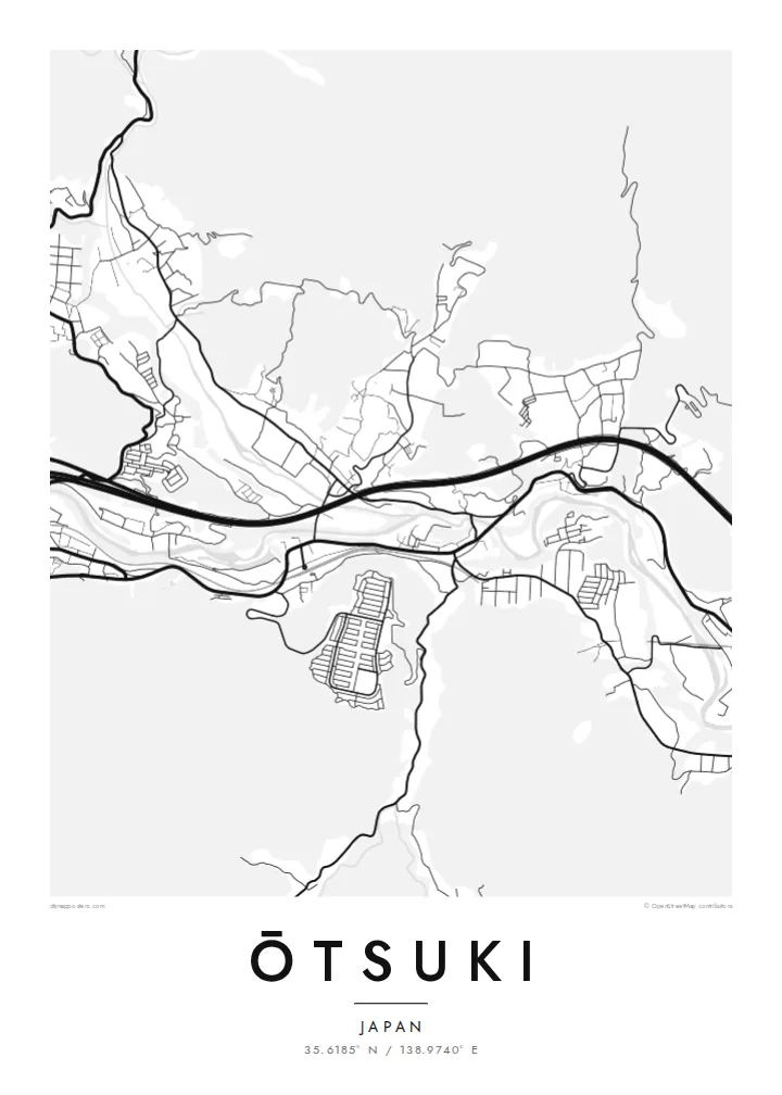
The river winds through the narrow valley, and almost every road and railway follows it. That creates the long, bundled shape at the centre of the map.
Fakatino mape mukamuka · Japan
35.6185° N / 138.9740° E
A narrow mountain valley town where river, railway and expressway squeeze together below steep forested slopes


Taha e taone, lima e onoonoaga
Tapaki e taha puhala ke kitia ai ki luga he puipui. Kua tatai e totogi he tau puhala oti — pete he lolomi, poloka, po ke faila HD.
 Tau pikselo mooli · faila lolomi 24 × 36″
Maama mitaki ke lolomi
Ko e 100% e fahi mooli mai he faila lolomi. Ko e tau poster oti — pete kua lolomi, poloka, po ke utu hifo — kua taute ke he ha mautolu a tau tokoluga (server) ke he 300 DPI, hokotia ke he 7,200 × 10,800 piksela, ke maeke ai e tau ala ikiiki tote ke maaliali fakamitaki he lolomi 24 × 36″.
He Pā


Ko e mape
Ōtsuki lies in eastern Yamanashi, in a deep valley surrounded by steep, wooded mountains. From above the town is long and narrow. The Katsura River, the JR Chūō Main Line and the Chūō Expressway all follow the valley floor, with homes and small streets fitted into whatever flat land remains between them.
Ōtsuki is a junction on the route to Mount Fuji. The Fujikyū line branches south from Ōtsuki Station toward Fujiyoshida and Kawaguchiko, so many travellers change trains here. Just east of the centre is the Saruhashi, the Monkey Bridge, a wooden cantilever bridge over a gorge, often counted among Japan's three unusual bridges.
An Ōtsuki map poster shows the town squeezed into its setting. The river and transport lines form strong parallel curves, and the mountains appear as broad empty areas crossed by only a few winding roads. It is a clear record of how a Japanese valley town is shaped by its terrain, and it suits both residents and Fuji travellers.
The river winds through the narrow valley, and almost every road and railway follows it. That creates the long, bundled shape at the centre of the map.
The Monkey Bridge spans a narrow gorge east of the centre. This wooden cantilever bridge is one of the best-known historic structures in the region.
At Ōtsuki Station the Fujikyū line leaves the Chūō Main Line and heads south toward Mount Fuji, giving the map a branching rail line.
Taute ke ha hau
Lafi e aho, taha higoa po ke taha kupu haau, hiki e fakatino, lahi po ke tuaga.
Ko e kitiaaga nakai totogi kua tote e maaliali mo e fakamailoga vai. Ko e tau lolomi mo e tau faila HD kua taute ke he 300 DPI, hokotia ke he 7,200 × 10,800 px, nakai fai fakamailoga vai.
Ko e ha Ōtsuki
Many people pass through Ōtsuki on the way to Fuji, and some stay long enough to know its valley well. The map captures that transit role and the dramatic setting, and the empty mountain areas make it a very graphic print.
Change the title and subtitle, including Japanese text if you prefer, and add a date or adjust the coordinates line. The five styles are Classic black and white, Noir, Paper, Blueprint and Sand. Noir works well with the narrow valley.
Talaage e poster Ōtsuki| Lahi he lolomi | Maama | Tau faila |
|---|---|---|
| 30 × 40 cm11.8 × 15.7″ | 3,543 × 4,724 px | PNG · PDF |
| 29.7 × 42 cm (A3)11.7 × 16.5″ | 3,508 × 4,961 px | PNG · PDF |
| 42 × 59.4 cm (A2)16.5 × 23.4″ | 4,961 × 7,016 px | PNG · PDF |
| 45.7 × 61 cm18 × 24″ | 5,400 × 7,200 px | PNG · PDF |
| 50 × 70 cm19.7 × 27.6″ | 5,906 × 8,268 px | PNG · PDF |
| 61 × 91.4 cm24 × 36″ | 7,200 × 10,800 px | PNG · PDF |
Ke fakatatai, ko e fakatino noa kua 900 px e laulahi, fai fakamailoga mo e mo e tau mata komipiuta ni. Ko e tau faila HD kua ato hoko ke he 8× e maama ke he tau faahi takitaha mo e lolomi mitaki he lahi katoa he fakatino.
Fifili e taha puhala i luga he kupega, ti fifili e Poster Lolomi — e lahi mo e, kaeke ke manako ai koe, taha poloka — po ke Tau Faila HD Fakaeletonika. Ko e fakaotiaga totogi ko e taha gahua ni, ti ko e kupega he hau a talaaga ka fakafou fakahaga i mua he fakaotiaga e totogi.
Kua lolomi ai ke he pepa mitaki 200 gsm matte he taha he tau lahi ono, mai he 30 × 40 cm ke hoko ke he 24 × 36″. Kamata e tau poster lolomi mai he $39, kua putoia ai e utaaga.
E. Fifili e poloka akau malolō ke he lanu uli, tea, akau oki mooli, po ke akau pouli. Kua fakalataha mo e sioga malolō nakai malepe ti kua mautali ke tautau. Kamata e tau poster poloka mai he $99, kua putoia ai e utaaga.
Nakai totogi e fakafano ke he motu 60+. Ko e fakatino taha kua lolomi he fenoga lolomi ha mautolu kua tata mo e tau motu 30+, kua hoko mai he tau aho gahua 3–7. Maeke ia koe ke kikite e tuaga mo e fakamuitua he lalo he Haku Tau Fakatonu. Ke he falu motu kua 2–5 e tau tapu, ti ka nakai fakafano a mautolu ki ai, to fakaha he api tupe ia ki mua he totogi.
Fakafano mai e taha ata ki a mautolu he loto he 14 e tau aho tali mai he hokoaga, ti to lolomi foki e mautolu nakai totogi po ke liu atu e totogi ki a koe.
E. He editor i luga he kupega nei, hikihiki e matakupu, e matakupu lalo mo e laini coordinates ke he taha mena kua manako a koe ki ai, ti fifili e puhala mo e lahi. Ko e tau talaaga lolomi, poloka mo e fakaeletonika oti kua fakaaoga tonu e hau a fakatino.
Ma e $9 ka moua e koe e tau faila PNG 300 DPI mo e PDF kua mautali ke lolomi he tau lahi ono oti, nakai fai fakamailoga vai, ke lolomi i fe mena. Nakai maopoopo agaia? Utu hifo fakamua e kitiaaga nakai totogi ne fai fakamailoga vai.
Tata mai
