The great square
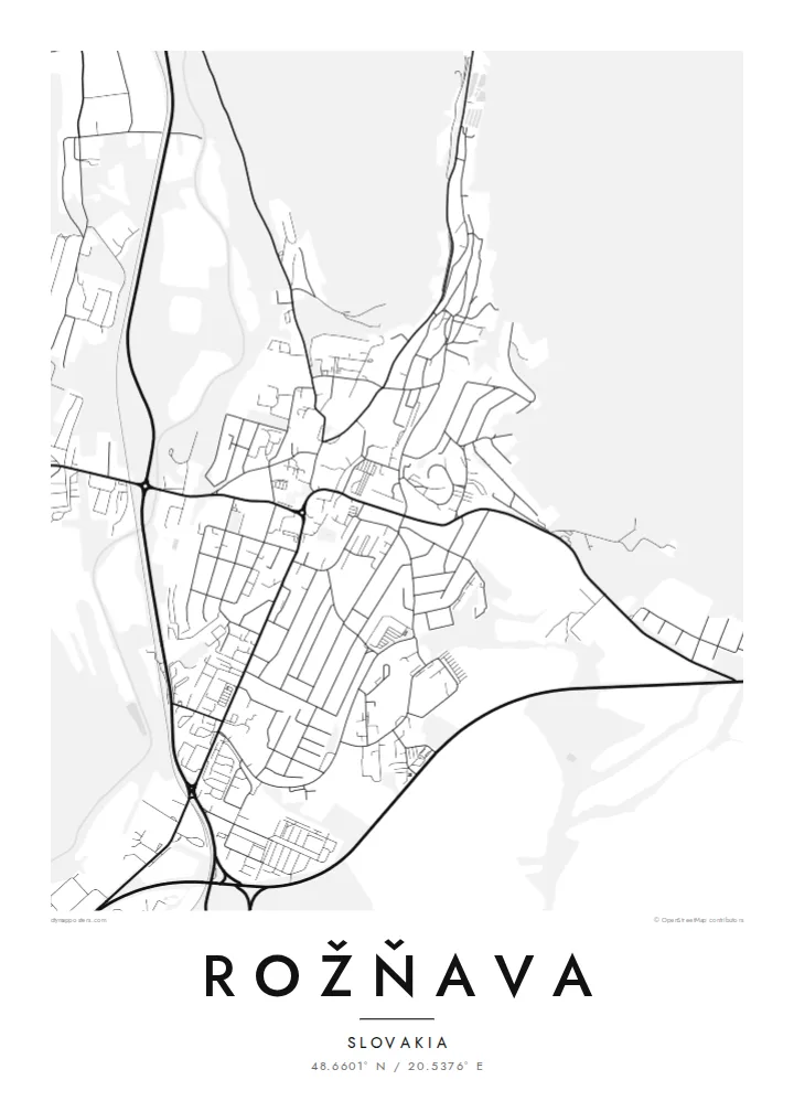
The historic core is one of the largest town squares in Slovakia. On the map it is a broad open rectangle, with a watchtower standing alone near its centre.
Fakatino mape mukamuka · Slovakia
48.6601° N / 20.5376° E
A mining town in the Slaná valley, built around one vast rectangular square with a lone tower standing in the middle


Taha e taone, lima e onoonoaga
Tapaki e taha puhala ke kitia ai ki luga he puipui. Kua tatai e totogi he tau puhala oti — pete he lolomi, poloka, po ke faila HD.
 Tau pikselo mooli · faila lolomi 24 × 36″
Maama mitaki ke lolomi
Ko e 100% e fahi mooli mai he faila lolomi. Ko e tau poster oti — pete kua lolomi, poloka, po ke utu hifo — kua taute ke he ha mautolu a tau tokoluga (server) ke he 300 DPI, hokotia ke he 7,200 × 10,800 piksela, ke maeke ai e tau ala ikiiki tote ke maaliali fakamitaki he lolomi 24 × 36″.
He Pā


Ko e mape
Rožňava sits in the valley of the Slaná river in eastern Slovakia, where the land narrows between wooded hills. From above, the plan is easy to read. A very large rectangular square takes up the historic core, and the older streets run off it in tight parallel lines. Newer housing blocks and suburbs spread along the valley floor, following the river and the roads toward Košice and the west.
The town grew from mining. For centuries gold, silver and later iron ore were dug from the surrounding hills, and the regular medieval plan still reflects that prosperity. In the middle of the square stands a free-standing watchtower, a clear vertical mark in the centre of the map. Rožňava is also a bishop's seat, and its cathedral sits near the old core. It is a quiet, orderly plan with a long past.
A Rožňava map poster shows how firmly the town is held by its landscape. The streets end where the slopes begin. The Slaná traces a soft curve beside the grid, and roads leave the valley in thin threads. Nearby lie the limestone plateaus of the Slovak Karst and the hilltop castle of Krásna Hôrka, so the town works as a gateway to one of the most distinctive landscapes in the country.
The historic core is one of the largest town squares in Slovakia. On the map it is a broad open rectangle, with a watchtower standing alone near its centre.
The river runs through the valley beside the town and guides where it has grown. Housing and roads stretch along its course instead of climbing the steep, wooded slopes.
South and west of town the land rises toward the plateaus of the Slovak Karst. On the poster it shows as open space around the dense centre.
Taute ke ha hau
Lafi e aho, taha higoa po ke taha kupu haau, hiki e fakatino, lahi po ke tuaga.
Ko e kitiaaga nakai totogi kua tote e maaliali mo e fakamailoga vai. Ko e tau lolomi mo e tau faila HD kua taute ke he 300 DPI, hokotia ke he 7,200 × 10,800 px, nakai fai fakamailoga vai.
Ko e ha Rožňava
For people from Gemer, or anyone who has walked across that wide square, this map carries a real sense of place. The plan is simple and clear: one central rectangle, a river, and hills all around. It reads well on a wall at any size.
You can set your own title, subtitle and coordinates line, for example a family name, a year you lived there, or the date of a visit. Choose one of five styles: Classic black & white, Noir, Paper, Blueprint or Sand. Then buy the $9 HD files or order a framed print.
Talaage e poster Rožňava| Lahi he lolomi | Maama | Tau faila |
|---|---|---|
| 30 × 40 cm11.8 × 15.7″ | 3,543 × 4,724 px | PNG · PDF |
| 29.7 × 42 cm (A3)11.7 × 16.5″ | 3,508 × 4,961 px | PNG · PDF |
| 42 × 59.4 cm (A2)16.5 × 23.4″ | 4,961 × 7,016 px | PNG · PDF |
| 45.7 × 61 cm18 × 24″ | 5,400 × 7,200 px | PNG · PDF |
| 50 × 70 cm19.7 × 27.6″ | 5,906 × 8,268 px | PNG · PDF |
| 61 × 91.4 cm24 × 36″ | 7,200 × 10,800 px | PNG · PDF |
Ke fakatatai, ko e fakatino noa kua 900 px e laulahi, fai fakamailoga mo e mo e tau mata komipiuta ni. Ko e tau faila HD kua ato hoko ke he 8× e maama ke he tau faahi takitaha mo e lolomi mitaki he lahi katoa he fakatino.
Fifili e taha puhala i luga he kupega, ti fifili e Poster Lolomi — e lahi mo e, kaeke ke manako ai koe, taha poloka — po ke Tau Faila HD Fakaeletonika. Ko e fakaotiaga totogi ko e taha gahua ni, ti ko e kupega he hau a talaaga ka fakafou fakahaga i mua he fakaotiaga e totogi.
Kua lolomi ai ke he pepa mitaki 200 gsm matte he taha he tau lahi ono, mai he 30 × 40 cm ke hoko ke he 24 × 36″. Kamata e tau poster lolomi mai he $39, kua putoia ai e utaaga.
E. Fifili e poloka akau malolō ke he lanu uli, tea, akau oki mooli, po ke akau pouli. Kua fakalataha mo e sioga malolō nakai malepe ti kua mautali ke tautau. Kamata e tau poster poloka mai he $99, kua putoia ai e utaaga.
Nakai totogi e fakafano ke he motu 60+. Ko e fakatino taha kua lolomi he fenoga lolomi ha mautolu kua tata mo e tau motu 30+, kua hoko mai he tau aho gahua 3–7. Maeke ia koe ke kikite e tuaga mo e fakamuitua he lalo he Haku Tau Fakatonu. Ke he falu motu kua 2–5 e tau tapu, ti ka nakai fakafano a mautolu ki ai, to fakaha he api tupe ia ki mua he totogi.
Fakafano mai e taha ata ki a mautolu he loto he 14 e tau aho tali mai he hokoaga, ti to lolomi foki e mautolu nakai totogi po ke liu atu e totogi ki a koe.
E. He editor i luga he kupega nei, hikihiki e matakupu, e matakupu lalo mo e laini coordinates ke he taha mena kua manako a koe ki ai, ti fifili e puhala mo e lahi. Ko e tau talaaga lolomi, poloka mo e fakaeletonika oti kua fakaaoga tonu e hau a fakatino.
Ma e $9 ka moua e koe e tau faila PNG 300 DPI mo e PDF kua mautali ke lolomi he tau lahi ono oti, nakai fai fakamailoga vai, ke lolomi i fe mena. Nakai maopoopo agaia? Utu hifo fakamua e kitiaaga nakai totogi ne fai fakamailoga vai.
