Futian central axis
A straight north–south corridor of parks and civic buildings runs up to Lianhua Mountain, framed by an orderly grid of avenues that makes the district easy to read from above.
Fakatino mape mukamuka · China
22.5455° N / 114.0683° E
A long coastal strip of planned districts facing Hong Kong across a narrow river and the open water of Shenzhen Bay


Taha e taone, lima e onoonoaga
Tapaki e taha puhala ke kitia ai ki luga he puipui. Kua tatai e totogi he tau puhala oti — pete he lolomi, poloka, po ke faila HD.
 Tau pikselo mooli · faila lolomi 24 × 36″
Maama mitaki ke lolomi
Ko e 100% e fahi mooli mai he faila lolomi. Ko e tau poster oti — pete kua lolomi, poloka, po ke utu hifo — kua taute ke he ha mautolu a tau tokoluga (server) ke he 300 DPI, hokotia ke he 7,200 × 10,800 piksela, ke maeke ai e tau ala ikiiki tote ke maaliali fakamitaki he lolomi 24 × 36″.
He Pā


Ko e mape
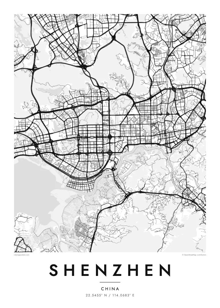
Shenzhen stretches east to west along the border with Hong Kong, which follows the Shenzhen River before opening into Shenzhen Bay. The city is long rather than round, arranged as a chain of districts, from Nanshan and Shekou in the west through Futian and Luohu toward the hills and coves of Yantian and Dapeng in the east. Green ridges push between them, so the built-up area appears in broad, separate bands.
Futian is the clearest piece of planning on the map. Its central axis runs north from near the waterfront through the business district to Lianhua Mountain, flanked by an even grid of wide avenues. In the west, the Shenzhen Bay Bridge crosses the water toward Hong Kong, while reclaimed land along the bay gives the shoreline its straight, engineered edges.
Few cities have been drawn so quickly. In 1980 Shenzhen became one of China’s first Special Economic Zones, and an area of fishing villages and market towns grew into one of the country’s largest cities within a few decades. The Ping An Finance Centre in Futian rises to about 599 metres. A Shenzhen map poster records a city that was, in large part, designed on paper first.
A straight north–south corridor of parks and civic buildings runs up to Lianhua Mountain, framed by an orderly grid of avenues that makes the district easy to read from above.
Much of the western shore is reclaimed land, giving the bay long, straight edges, waterfront parks and a bridge that reaches across the water toward Hong Kong’s New Territories.
Beyond Luohu, the city thins out among ridges such as Wutong Mountain, and the coastline breaks into small bays and headlands toward the Dapeng peninsula.
Taute ke ha hau
Lafi e aho, taha higoa po ke taha kupu haau, hiki e fakatino, lahi po ke tuaga.
Ko e kitiaaga nakai totogi kua tote e maaliali mo e fakamailoga vai. Ko e tau lolomi mo e tau faila HD kua taute ke he 300 DPI, hokotia ke he 7,200 × 10,800 px, nakai fai fakamailoga vai.
Ko e ha Shenzhen
Shenzhen draws people who arrived for work and stayed, and it often marks a turning point: a first job, a new company, a new family. A poster of its planned districts and reclaimed shoreline is a way of fixing that chapter on a wall.
Personalise the title, subtitle and coordinates line with a district, a company name or the year you moved. The design comes in five styles, Classic black & white, Noir, Paper, Blueprint and Sand, and each is available as digital HD files or a printed poster.
Talaage e poster Shenzhen| Lahi he lolomi | Maama | Tau faila |
|---|---|---|
| 30 × 40 cm11.8 × 15.7″ | 3,543 × 4,724 px | PNG · PDF |
| 29.7 × 42 cm (A3)11.7 × 16.5″ | 3,508 × 4,961 px | PNG · PDF |
| 42 × 59.4 cm (A2)16.5 × 23.4″ | 4,961 × 7,016 px | PNG · PDF |
| 45.7 × 61 cm18 × 24″ | 5,400 × 7,200 px | PNG · PDF |
| 50 × 70 cm19.7 × 27.6″ | 5,906 × 8,268 px | PNG · PDF |
| 61 × 91.4 cm24 × 36″ | 7,200 × 10,800 px | PNG · PDF |
Ke fakatatai, ko e fakatino noa kua 900 px e laulahi, fai fakamailoga mo e mo e tau mata komipiuta ni. Ko e tau faila HD kua ato hoko ke he 8× e maama ke he tau faahi takitaha mo e lolomi mitaki he lahi katoa he fakatino.
Fifili e taha puhala i luga he kupega, ti fifili e Poster Lolomi — e lahi mo e, kaeke ke manako ai koe, taha poloka — po ke Tau Faila HD Fakaeletonika. Ko e fakaotiaga totogi ko e taha gahua ni, ti ko e kupega he hau a talaaga ka fakafou fakahaga i mua he fakaotiaga e totogi.
Kua lolomi ai ke he pepa mitaki 200 gsm matte he taha he tau lahi ono, mai he 30 × 40 cm ke hoko ke he 24 × 36″. Kamata e tau poster lolomi mai he $39, kua putoia ai e utaaga.
E. Fifili e poloka akau malolō ke he lanu uli, tea, akau oki mooli, po ke akau pouli. Kua fakalataha mo e sioga malolō nakai malepe ti kua mautali ke tautau. Kamata e tau poster poloka mai he $99, kua putoia ai e utaaga.
Nakai totogi e fakafano ke he motu 60+. Ko e fakatino taha kua lolomi he fenoga lolomi ha mautolu kua tata mo e tau motu 30+, kua hoko mai he tau aho gahua 3–7. Maeke ia koe ke kikite e tuaga mo e fakamuitua he lalo he Haku Tau Fakatonu. Ke he falu motu kua 2–5 e tau tapu, ti ka nakai fakafano a mautolu ki ai, to fakaha he api tupe ia ki mua he totogi.
Fakafano mai e taha ata ki a mautolu he loto he 14 e tau aho tali mai he hokoaga, ti to lolomi foki e mautolu nakai totogi po ke liu atu e totogi ki a koe.
E. He editor i luga he kupega nei, hikihiki e matakupu, e matakupu lalo mo e laini coordinates ke he taha mena kua manako a koe ki ai, ti fifili e puhala mo e lahi. Ko e tau talaaga lolomi, poloka mo e fakaeletonika oti kua fakaaoga tonu e hau a fakatino.
Ma e $9 ka moua e koe e tau faila PNG 300 DPI mo e PDF kua mautali ke lolomi he tau lahi ono oti, nakai fai fakamailoga vai, ke lolomi i fe mena. Nakai maopoopo agaia? Utu hifo fakamua e kitiaaga nakai totogi ne fai fakamailoga vai.
Tata mai
