Verrazzano-Narrows Bridge
This long suspension span crosses the Narrows from the island's northeast corner to Brooklyn. On the map it is a single clean line over open water, marking the entrance to New York Harbor.
Fakatino mape mukamuka · United States
40.5623° N / 74.1399° W
An island borough ringed by kills and bays, crossed by one great bridge and centred on a long green spine




Taha e taone, lima e onoonoaga
Tapaki e taha puhala ke kitia ai ki luga he puipui. Kua tatai e totogi he tau puhala oti — pete he lolomi, poloka, po ke faila HD.
 Tau pikselo mooli · faila lolomi 24 × 36″
Maama mitaki ke lolomi
Ko e 100% e fahi mooli mai he faila lolomi. Ko e tau poster oti — pete kua lolomi, poloka, po ke utu hifo — kua taute ke he ha mautolu a tau tokoluga (server) ke he 300 DPI, hokotia ke he 7,200 × 10,800 piksela, ke maeke ai e tau ala ikiiki tote ke maaliali fakamitaki he lolomi 24 × 36″.
He Pā


Ko e mape
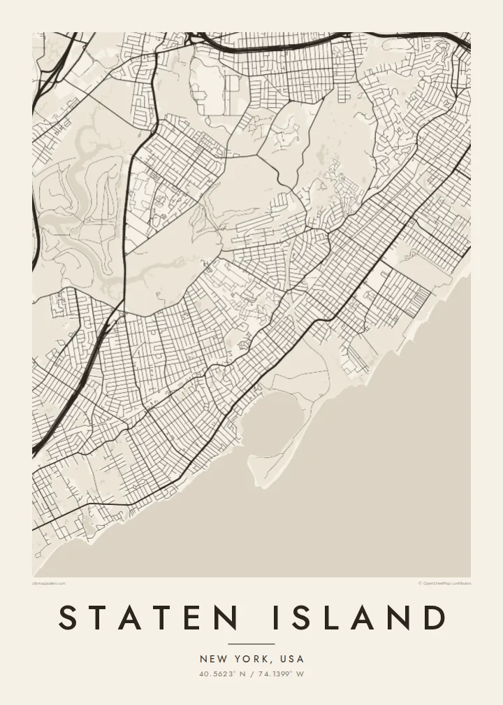
Staten Island is the most southern of New York City's five boroughs, and its outline is unmistakable on a map. The Kill Van Kull runs along its north shore, the Arthur Kill separates it from New Jersey on the west, and Lower New York Bay and Raritan Bay wrap the east and south. Inside that outline, the street pattern changes from dense grids near the ferry to looser suburban loops further south.
Four bridges tie the island to its neighbours: the Verrazzano-Narrows Bridge to Brooklyn, and the Goethals Bridge, Bayonne Bridge and Outerbridge Crossing to New Jersey. The Staten Island Expressway runs across the middle to link them. The free Staten Island Ferry leaves from St. George at the northern tip and has long carried commuters and visitors across the harbour to Manhattan.
A Staten Island map poster shows how much open land the borough still has. The Greenbelt fills a large wooded area in the middle, and on the west side, the former Fresh Kills landfill is being turned into Freshkills Park. Tidal creeks and marshes cut into the shoreline, so the edges look soft and uneven.
This long suspension span crosses the Narrows from the island's northeast corner to Brooklyn. On the map it is a single clean line over open water, marking the entrance to New York Harbor.
A connected stretch of woods, trails and parkland runs through the centre of the island. In black and white, it shows up as a large quiet area among the surrounding streets.
At the northern tip, the ferry terminal sits where the Kill Van Kull meets the Upper Bay. From here the dense early grid spreads uphill and gradually loosens as it moves inland.
Taute ke ha hau
Lafi e aho, taha higoa po ke taha kupu haau, hiki e fakatino, lahi po ke tuaga.
Ko e kitiaaga nakai totogi kua tote e maaliali mo e fakamailoga vai. Ko e tau lolomi mo e tau faila HD kua taute ke he 300 DPI, hokotia ke he 7,200 × 10,800 px, nakai fai fakamailoga vai.
Ko e ha Staten Island
For many New Yorkers, Staten Island is home, and it is a place people feel strongly about. The island's outline makes a clear shape for a poster, and the bridges and green centre give it more detail than a plain street grid.
Add a personal title, a subtitle naming your neighbourhood and a coordinates line, then choose Classic black & white, Noir, Paper, Blueprint or Sand. HD files cost $9 in six print sizes, and printed posters come on matte paper with an optional wooden frame.
Talaage e poster Staten Island| Lahi he lolomi | Maama | Tau faila |
|---|---|---|
| 30 × 40 cm11.8 × 15.7″ | 3,543 × 4,724 px | PNG · PDF |
| 29.7 × 42 cm (A3)11.7 × 16.5″ | 3,508 × 4,961 px | PNG · PDF |
| 42 × 59.4 cm (A2)16.5 × 23.4″ | 4,961 × 7,016 px | PNG · PDF |
| 45.7 × 61 cm18 × 24″ | 5,400 × 7,200 px | PNG · PDF |
| 50 × 70 cm19.7 × 27.6″ | 5,906 × 8,268 px | PNG · PDF |
| 61 × 91.4 cm24 × 36″ | 7,200 × 10,800 px | PNG · PDF |
Ke fakatatai, ko e fakatino noa kua 900 px e laulahi, fai fakamailoga mo e mo e tau mata komipiuta ni. Ko e tau faila HD kua ato hoko ke he 8× e maama ke he tau faahi takitaha mo e lolomi mitaki he lahi katoa he fakatino.
Fifili e taha puhala i luga he kupega, ti fifili e Poster Lolomi — e lahi mo e, kaeke ke manako ai koe, taha poloka — po ke Tau Faila HD Fakaeletonika. Ko e fakaotiaga totogi ko e taha gahua ni, ti ko e kupega he hau a talaaga ka fakafou fakahaga i mua he fakaotiaga e totogi.
Kua lolomi ai ke he pepa mitaki 200 gsm matte he taha he tau lahi ono, mai he 30 × 40 cm ke hoko ke he 24 × 36″. Kamata e tau poster lolomi mai he $39, kua putoia ai e utaaga.
E. Fifili e poloka akau malolō ke he lanu uli, tea, akau oki mooli, po ke akau pouli. Kua fakalataha mo e sioga malolō nakai malepe ti kua mautali ke tautau. Kamata e tau poster poloka mai he $99, kua putoia ai e utaaga.
Nakai totogi e fakafano ke he motu 60+. Ko e fakatino taha kua lolomi he fenoga lolomi ha mautolu kua tata mo e tau motu 30+, kua hoko mai he tau aho gahua 3–7. Maeke ia koe ke kikite e tuaga mo e fakamuitua he lalo he Haku Tau Fakatonu. Ke he falu motu kua 2–5 e tau tapu, ti ka nakai fakafano a mautolu ki ai, to fakaha he api tupe ia ki mua he totogi.
Fakafano mai e taha ata ki a mautolu he loto he 14 e tau aho tali mai he hokoaga, ti to lolomi foki e mautolu nakai totogi po ke liu atu e totogi ki a koe.
E. He editor i luga he kupega nei, hikihiki e matakupu, e matakupu lalo mo e laini coordinates ke he taha mena kua manako a koe ki ai, ti fifili e puhala mo e lahi. Ko e tau talaaga lolomi, poloka mo e fakaeletonika oti kua fakaaoga tonu e hau a fakatino.
Ma e $9 ka moua e koe e tau faila PNG 300 DPI mo e PDF kua mautali ke lolomi he tau lahi ono oti, nakai fai fakamailoga vai, ke lolomi i fe mena. Nakai maopoopo agaia? Utu hifo fakamua e kitiaaga nakai totogi ne fai fakamailoga vai.
Tata mai
