Castle ridge
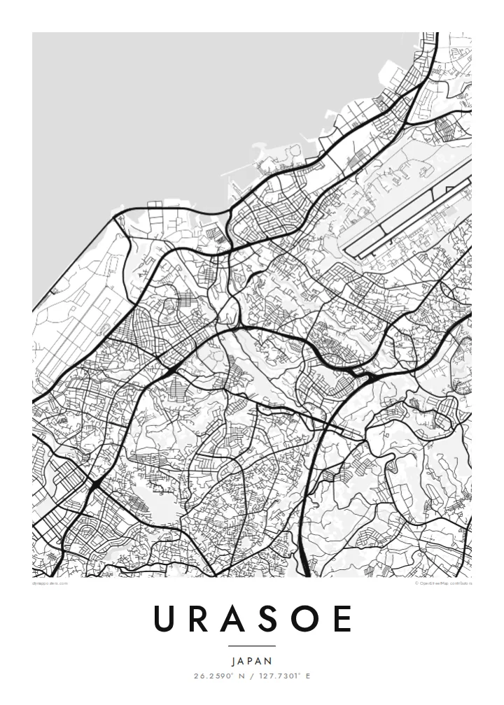
The site of Urasoe Castle and the nearby royal tombs sit on a wooded limestone ridge. It leaves a green gap in the urban fabric that the roads bend around.
Fakatino mape mukamuka · Japan
26.2590° N / 127.7301° E
A hilly Okinawan city between the East China Sea and a limestone ridge crowned by an old castle site


Taha e taone, lima e onoonoaga
Tapaki e taha puhala ke kitia ai ki luga he puipui. Kua tatai e totogi he tau puhala oti — pete he lolomi, poloka, po ke faila HD.
 Tau pikselo mooli · faila lolomi 24 × 36″
Maama mitaki ke lolomi
Ko e 100% e fahi mooli mai he faila lolomi. Ko e tau poster oti — pete kua lolomi, poloka, po ke utu hifo — kua taute ke he ha mautolu a tau tokoluga (server) ke he 300 DPI, hokotia ke he 7,200 × 10,800 piksela, ke maeke ai e tau ala ikiiki tote ke maaliali fakamitaki he lolomi 24 × 36″.
He Pā


Ko e mape
Urasoe lies on the west coast of Okinawa Island, directly north of Naha, and on a map the two cities merge into one continuous urban area. The street pattern here is dense but uneven. Narrow lanes wind over low hills, main roads run north–south parallel to the coast, and neighbourhoods fill the gaps in irregular, tightly packed blocks.
Before Shuri became the royal seat, Urasoe was a centre of power on the island. The ruins of Urasoe Castle stand on a ridge in the east of the city, beside the Urasoe Yōdore, royal tombs carved into the cliff. From above, the ridge appears as a green band that the surrounding streets curve around instead of crossing.
Toward the sea the pattern changes. The coastal strip includes a large area of reclaimed and military land, drawn in long straight lines and open spaces that contrast with the fine-grained residential streets inland. An Urasoe map poster brings together the coastline, the ridge and the dense city between them, a place where history sits close to everyday streets.
The site of Urasoe Castle and the nearby royal tombs sit on a wooded limestone ridge. It leaves a green gap in the urban fabric that the roads bend around.
Along the East China Sea, reclaimed land and large institutional sites form broad, regular shapes, very different from the compact neighbourhoods further inland.
Main roads run north–south through the city, linking it to Naha and the centre of the island. They give the dense map a clear sense of direction.
Taute ke ha hau
Lafi e aho, taha higoa po ke taha kupu haau, hiki e fakatino, lahi po ke tuaga.
Ko e kitiaaga nakai totogi kua tote e maaliali mo e fakamailoga vai. Ko e tau lolomi mo e tau faila HD kua taute ke he 300 DPI, hokotia ke he 7,200 × 10,800 px, nakai fai fakamailoga vai.
Ko e ha Urasoe
Many people who live in Urasoe work in Naha, yet think of this hillside city as their own. It also matters to anyone interested in the early history of the Ryūkyū Kingdom, and the map holds both the everyday and the historical.
Set the title, add a subtitle and a date, or keep the coordinates line as it is. Five styles are available, from Classic black & white to the blue tones of Blueprint and the warm Sand. Order them as HD files for $9 or as a printed poster.
Talaage e poster Urasoe| Lahi he lolomi | Maama | Tau faila |
|---|---|---|
| 30 × 40 cm11.8 × 15.7″ | 3,543 × 4,724 px | PNG · PDF |
| 29.7 × 42 cm (A3)11.7 × 16.5″ | 3,508 × 4,961 px | PNG · PDF |
| 42 × 59.4 cm (A2)16.5 × 23.4″ | 4,961 × 7,016 px | PNG · PDF |
| 45.7 × 61 cm18 × 24″ | 5,400 × 7,200 px | PNG · PDF |
| 50 × 70 cm19.7 × 27.6″ | 5,906 × 8,268 px | PNG · PDF |
| 61 × 91.4 cm24 × 36″ | 7,200 × 10,800 px | PNG · PDF |
Ke fakatatai, ko e fakatino noa kua 900 px e laulahi, fai fakamailoga mo e mo e tau mata komipiuta ni. Ko e tau faila HD kua ato hoko ke he 8× e maama ke he tau faahi takitaha mo e lolomi mitaki he lahi katoa he fakatino.
Fifili e taha puhala i luga he kupega, ti fifili e Poster Lolomi — e lahi mo e, kaeke ke manako ai koe, taha poloka — po ke Tau Faila HD Fakaeletonika. Ko e fakaotiaga totogi ko e taha gahua ni, ti ko e kupega he hau a talaaga ka fakafou fakahaga i mua he fakaotiaga e totogi.
Kua lolomi ai ke he pepa mitaki 200 gsm matte he taha he tau lahi ono, mai he 30 × 40 cm ke hoko ke he 24 × 36″. Kamata e tau poster lolomi mai he $39, kua putoia ai e utaaga.
E. Fifili e poloka akau malolō ke he lanu uli, tea, akau oki mooli, po ke akau pouli. Kua fakalataha mo e sioga malolō nakai malepe ti kua mautali ke tautau. Kamata e tau poster poloka mai he $99, kua putoia ai e utaaga.
Nakai totogi e fakafano ke he motu 60+. Ko e fakatino taha kua lolomi he fenoga lolomi ha mautolu kua tata mo e tau motu 30+, kua hoko mai he tau aho gahua 3–7. Maeke ia koe ke kikite e tuaga mo e fakamuitua he lalo he Haku Tau Fakatonu. Ke he falu motu kua 2–5 e tau tapu, ti ka nakai fakafano a mautolu ki ai, to fakaha he api tupe ia ki mua he totogi.
Fakafano mai e taha ata ki a mautolu he loto he 14 e tau aho tali mai he hokoaga, ti to lolomi foki e mautolu nakai totogi po ke liu atu e totogi ki a koe.
E. He editor i luga he kupega nei, hikihiki e matakupu, e matakupu lalo mo e laini coordinates ke he taha mena kua manako a koe ki ai, ti fifili e puhala mo e lahi. Ko e tau talaaga lolomi, poloka mo e fakaeletonika oti kua fakaaoga tonu e hau a fakatino.
Ma e $9 ka moua e koe e tau faila PNG 300 DPI mo e PDF kua mautali ke lolomi he tau lahi ono oti, nakai fai fakamailoga vai, ke lolomi i fe mena. Nakai maopoopo agaia? Utu hifo fakamua e kitiaaga nakai totogi ne fai fakamailoga vai.
