Temple quarter
Narrow lanes cluster around the Dwarkadhish Temple near the Gomti river, forming the densest and most intricate part of the map.
Minimalistische kaartposter · India
22.2394° N / 68.9678° E
A temple town at the western tip of Saurashtra, where the Gomti meets the Arabian Sea and an island lies offshore


Eén stad, vijf sferen
Tik op een stijl om hem aan de muur te zien. Elke stijl kost hetzelfde — geprint, ingelijst of als HD-bestanden.
 Werkelijke pixels · 24 × 36″ printbestand
Haarscherp gedrukt
Dit is een uitsnede op ware grootte van het echte printbestand. Elke poster — geprint, ingelijst of gedownload — wordt op onze servers gerenderd op 300 DPI, tot 7,200 × 10,800 pixels, zodat zelfs de kleinste straatjes scherp blijven op een print van 24 × 36″.
Aan de muur


De kaart
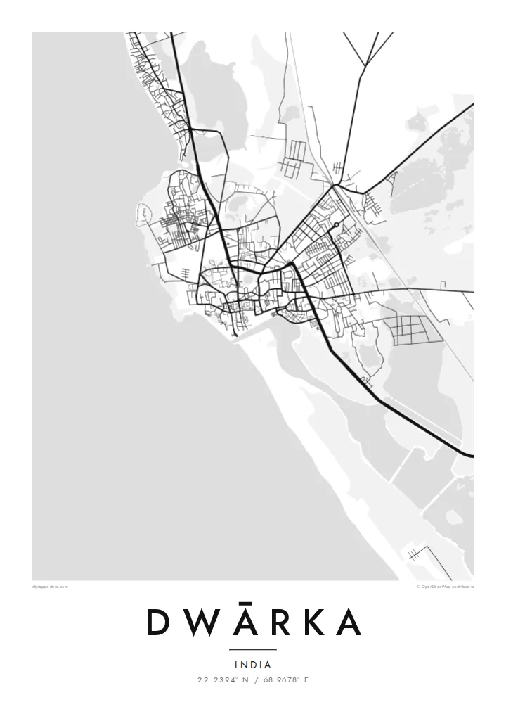
Dwārka sits at the far western end of the Saurashtra peninsula in Gujarat, facing the Arabian Sea. On the map, the old town is a dense cluster of narrow lanes around the Dwarkadhish Temple, near the point where the Gomti river meets the sea. Beyond the old centre the streets become more open, and the coast curves away in both directions, rocky in places and sandy in others.
Dwārka is one of the four Char Dham pilgrimage sites of Hinduism, associated in tradition with Krishna, and draws large numbers of pilgrims every year. Just offshore to the north lies Beyt Dwarka, an island with its own temples, which since 2024 has been connected to the mainland by the Sudarshan Setu, a long cable-stayed bridge.
A Dwārka map poster shows a sacred city defined by its edges: the sea to the west, the river mouth, the tight maze of the old town and the coastline running north toward the island. In black and white, the dense lanes around the temple stand out clearly against the broad, empty expanse of the sea.
Narrow lanes cluster around the Dwarkadhish Temple near the Gomti river, forming the densest and most intricate part of the map.
The Gomti meets the Arabian Sea right beside the old town, where the ghats and the temple face the water.
The shoreline runs along the western edge of the peninsula, rocky and irregular, giving the map a strong and dramatic edge.
Maak hem persoonlijk
Voeg een datum, een naam of je eigen tekst toe, en wissel van stijl, formaat of oriëntatie.
De gratis voorbeeldweergave is lage resolutie met watermerk. Prints en HD-bestanden worden gerenderd op 300 DPI, tot 7,200 × 10,800 px, zonder watermerk.
Waarom Dwārka
For pilgrims, families from Gujarat and anyone who has walked from the temple down to the Gomti ghats, Dwārka carries deep personal meaning. The map is a respectful way to keep that journey close at home.
Add the date of your pilgrimage or a family name to the title, edit the subtitle and coordinates, and choose one of five styles. The $9 download covers six print sizes, each as a 300 DPI PNG and PDF.
Bestel de poster Dwārka| Printformaat | Resolutie | Bestanden |
|---|---|---|
| 30 × 40 cm (11.8 × 15.7″) | 3,543 × 4,724 px | PNG · PDF |
| 29.7 × 42 cm (A3, 11.7 × 16.5″) | 3,508 × 4,961 px | PNG · PDF |
| 42 × 59.4 cm (A2, 16.5 × 23.4″) | 4,961 × 7,016 px | PNG · PDF |
| 45.7 × 61 cm (18 × 24″) | 5,400 × 7,200 px | PNG · PDF |
| 50 × 70 cm (19.7 × 27.6″) | 5,906 × 8,268 px | PNG · PDF |
| 61 × 91.4 cm (24 × 36″) | 7,200 × 10,800 px | PNG · PDF |
Ter vergelijking: de gratis preview is 900 px breed, heeft een watermerk en is bedoeld voor schermen. De HD-bestanden hebben tot 8× de resolutie in elke richting en worden haarscherp geprint op volledig posterformaat.
Kies bovenaan de pagina een stijl en kies dan voor Geprinte Poster — een formaat en eventueel een lijst — of Digitale HD-bestanden. Afrekenen kost één stap, en je bestelpagina wordt direct bijgewerkt zodra de betaling is verwerkt.
Hij wordt geprint op premium mat papier van 200 g/m² in een van zes formaten, van 30 × 40 cm tot 24 × 36″. Geprinte posters beginnen vanaf {printFrom}, verzending inbegrepen.
Ja. Kies een massief houten lijst in zwart, wit, natuurlijk eiken of donker hout. Inclusief breukvast glas en direct op te hangen. Ingelijste posters beginnen vanaf {framedFrom}, verzending inbegrepen.
Verzending is wereldwijd gratis. Elke poster wordt gedrukt door de dichtstbijzijnde van onze drukpartners in meer dan 30 landen en is meestal binnen 3–7 werkdagen bij je. Je volgt de status en track & trace onder Mijn bestellingen. In een paar landen duurt het 2–5 weken, en waar we nog niet naartoe verzenden, laat de site dat je zien voordat je betaalt.
Stuur ons binnen 14 dagen na levering een foto en we printen hem gratis opnieuw of betalen je terug.
Ja. Pas in de editor op deze pagina de titel, de ondertitel en de coördinatenregel aan zoals je wilt, en kies een stijl en formaat. Geprinte, ingelijste en digitale bestellingen gebruiken allemaal precies jouw ontwerp.
Voor $9 krijg je PNG-bestanden op 300 DPI en printklare PDF's in alle zes formaten, zonder watermerk, om overal te printen. Nog niet zeker? Download eerst een gratis voorbeeld met watermerk.
