Plaza del Dos de Mayo
The central square, named after the 1808 uprising, forms the main open space in the district, a small clearing in the dense street pattern.
Minimalistische kaartposter · Spanje
40.4267° N / 3.7042° W
A dense grid of short streets north of Gran Vía, gathered around the Plaza del Dos de Mayo



Eén stad, vijf sferen
Tik op een stijl om hem aan de muur te zien. Elke stijl kost hetzelfde — geprint, ingelijst of als HD-bestanden.
 Werkelijke pixels · 24 × 36″ printbestand
Haarscherp gedrukt
Dit is een uitsnede op ware grootte van het echte printbestand. Elke poster — geprint, ingelijst of gedownload — wordt op onze servers gerenderd op 300 DPI, tot 7,200 × 10,800 pixels, zodat zelfs de kleinste straatjes scherp blijven op een print van 24 × 36″.
Aan de muur


De kaart
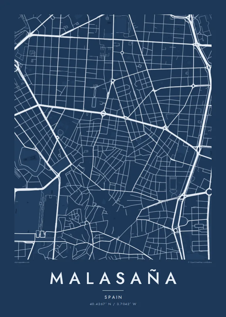
Malasaña lies in central Madrid, north of Gran Vía, and on the map it is a compact network of narrow streets and small, irregular blocks. It is roughly framed by Calle de Fuencarral on the east, Calle de San Bernardo on the west and the boulevard of Carranza and Sagasta to the north.
The district is named after Manuela Malasaña, a young woman killed during the uprising against French troops on 2 May 1808. Its central square, Plaza del Dos de Mayo, commemorates that day. In the late 1970s and 1980s the neighbourhood was a centre of La Movida Madrileña, the cultural movement that followed the end of the dictatorship.
A Malasaña map poster is intricate and tightly packed. The short streets meet at slightly uneven angles, the central plaza opens as a small clear space, and the straight line of Gran Vía along the southern edge gives the composition a firm base.
The central square, named after the 1808 uprising, forms the main open space in the district, a small clearing in the dense street pattern.
Calle de Fuencarral runs north from Gran Vía along the eastern side of the district, a long straight line separating Malasaña from Chueca.
The broad avenue along the southern edge is one of Madrid's main streets, a wide line that anchors the finer streets above it.
Maak hem persoonlijk
Voeg een datum, een naam of je eigen tekst toe, en wissel van stijl, formaat of oriëntatie.
De gratis voorbeeldweergave is lage resolutie met watermerk. Prints en HD-bestanden worden gerenderd op 300 DPI, tot 7,200 × 10,800 px, zonder watermerk.
Waarom Malasaña
Malasaña is a neighbourhood of late evenings, small bars and shared flats, and many people keep strong memories of a particular street or plaza. A map captures that density without needing any words.
Personalise the title, subtitle and coordinates line, perhaps with a street or year, and choose one of five styles. Noir fits the district's night life, while Sand brings a warm Madrid tone.
Bestel de poster Malasaña| Printformaat | Resolutie | Bestanden |
|---|---|---|
| 30 × 40 cm11.8 × 15.7″ | 3,543 × 4,724 px | PNG · PDF |
| 29.7 × 42 cm (A3)11.7 × 16.5″ | 3,508 × 4,961 px | PNG · PDF |
| 42 × 59.4 cm (A2)16.5 × 23.4″ | 4,961 × 7,016 px | PNG · PDF |
| 45.7 × 61 cm18 × 24″ | 5,400 × 7,200 px | PNG · PDF |
| 50 × 70 cm19.7 × 27.6″ | 5,906 × 8,268 px | PNG · PDF |
| 61 × 91.4 cm24 × 36″ | 7,200 × 10,800 px | PNG · PDF |
Ter vergelijking: de gratis preview is 900 px breed, heeft een watermerk en is bedoeld voor schermen. De HD-bestanden hebben tot 8× de resolutie in elke richting en worden haarscherp geprint op volledig posterformaat.
Kies bovenaan de pagina een stijl en kies dan voor Geprinte Poster — een formaat en eventueel een lijst — of Digitale HD-bestanden. Afrekenen kost één stap, en je bestelpagina wordt direct bijgewerkt zodra de betaling is verwerkt.
Hij wordt geprint op premium mat papier van 200 g/m² in een van zes formaten, van 30 × 40 cm tot 24 × 36″. Geprinte posters beginnen vanaf $39, verzending inbegrepen.
Ja. Kies een massief houten lijst in zwart, wit, natuurlijk eiken of donker hout. Inclusief breukvast glas en direct op te hangen. Ingelijste posters beginnen vanaf $99, verzending inbegrepen.
Verzending is gratis naar 60+ landen. Elke poster wordt gedrukt door de dichtstbijzijnde van onze drukpartners in 30+ landen en komt meestal binnen 3–7 werkdagen aan. Je volgt de status en de tracking onder Mijn bestellingen. In een paar landen duurt het 2–5 weken, en als we nog niet naar jouw land verzenden, laat de site dat zien voordat je betaalt.
Stuur ons binnen 14 dagen na levering een foto en we printen hem gratis opnieuw of betalen je terug.
Ja. Pas in de editor op deze pagina de titel, de ondertitel en de coördinatenregel aan zoals je wilt, en kies een stijl en formaat. Geprinte, ingelijste en digitale bestellingen gebruiken allemaal precies jouw ontwerp.
Voor $9 krijg je PNG-bestanden op 300 DPI en printklare PDF's in alle zes formaten, zonder watermerk, om overal te printen. Nog niet zeker? Download eerst een gratis voorbeeld met watermerk.
