Mohokare River
The Mohokare, or Caledon, meanders along the edge of Maputsoe and marks the border with South Africa. It gives the map its most fluid and distinctive line.
Minimalistische kaartposter · Lesotho
28.8866° S / 27.8991° E
A Lesotho border town on the Mohokare River, facing Ficksburg across a single bridge and busy border crossing.


Eén stad, vijf sferen
Tik op een stijl om hem aan de muur te zien. Elke stijl kost hetzelfde — geprint, ingelijst of als HD-bestanden.
 Werkelijke pixels · 24 × 36″ printbestand
Haarscherp gedrukt
Dit is een uitsnede op ware grootte van het echte printbestand. Elke poster — geprint, ingelijst of gedownload — wordt op onze servers gerenderd op 300 DPI, tot 7,200 × 10,800 pixels, zodat zelfs de kleinste straatjes scherp blijven op een print van 24 × 36″.
Aan de muur


De kaart
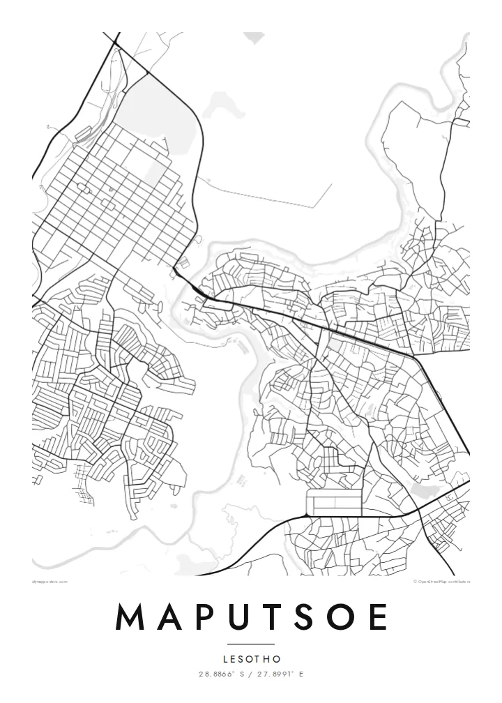
Maputsoe lies in Leribe District in northern Lesotho, right on the Mohokare River, which South Africa calls the Caledon. The river forms the international border here, and on the map it runs as a winding line along the town's western edge. Across the water lies Ficksburg in the Free State. The two towns are joined by the Maputsoe Bridge crossing, one of the main gateways into Lesotho.
That position has shaped the town. Maputsoe grew as a trading and transit point, and since the late twentieth century it has become an industrial centre, with textile and garment factories set in industrial areas near the border. On the map, these large factory blocks sit beside dense residential neighbourhoods that climb gently eastwards, away from the river, towards the foothills.
A Maputsoe map poster captures a town defined by a border. The Mohokare curves along one side, the bridge crossing ties it to its neighbour, and the streets spread inland across rising ground. It is a compact, readable composition with a strong natural line and a clear story.
The Mohokare, or Caledon, meanders along the edge of Maputsoe and marks the border with South Africa. It gives the map its most fluid and distinctive line.
The road crossing to Ficksburg is the town's link to South Africa. On the map it is a short but significant connection over the river.
Industrial areas with large, regular buildings sit near the crossing. They contrast with the smaller, irregular plots of the residential areas further east.
Maak hem persoonlijk
Voeg een datum, een naam of je eigen tekst toe, en wissel van stijl, formaat of oriëntatie.
De gratis voorbeeldweergave is lage resolutie met watermerk. Prints en HD-bestanden worden gerenderd op 300 DPI, tot 7,200 × 10,800 px, zonder watermerk.
Waarom Maputsoe
A map of Maputsoe means a lot to those who live, work or grew up in this border town, and to families on both sides of the river. It records a very particular place, a town shaped by a river and a crossing.
Personalise it with a title, a subtitle such as a date or family name, and a coordinates line. Then pick one of five styles, Classic black & white, Noir, Paper, Blueprint or Sand, to match your space.
Bestel de poster Maputsoe| Printformaat | Resolutie | Bestanden |
|---|---|---|
| 30 × 40 cm (11.8 × 15.7″) | 3,543 × 4,724 px | PNG · PDF |
| 29.7 × 42 cm (A3, 11.7 × 16.5″) | 3,508 × 4,961 px | PNG · PDF |
| 42 × 59.4 cm (A2, 16.5 × 23.4″) | 4,961 × 7,016 px | PNG · PDF |
| 45.7 × 61 cm (18 × 24″) | 5,400 × 7,200 px | PNG · PDF |
| 50 × 70 cm (19.7 × 27.6″) | 5,906 × 8,268 px | PNG · PDF |
| 61 × 91.4 cm (24 × 36″) | 7,200 × 10,800 px | PNG · PDF |
Ter vergelijking: de gratis preview is 900 px breed, heeft een watermerk en is bedoeld voor schermen. De HD-bestanden hebben tot 8× de resolutie in elke richting en worden haarscherp geprint op volledig posterformaat.
Kies bovenaan de pagina een stijl en kies dan voor Geprinte Poster — een formaat en eventueel een lijst — of Digitale HD-bestanden. Afrekenen kost één stap, en je bestelpagina wordt direct bijgewerkt zodra de betaling is verwerkt.
Hij wordt geprint op premium mat papier van 200 g/m² in een van zes formaten, van 30 × 40 cm tot 24 × 36″. Geprinte posters beginnen vanaf {printFrom}, verzending inbegrepen.
Ja. Kies een massief houten lijst in zwart, wit, natuurlijk eiken of donker hout. Inclusief breukvast glas en direct op te hangen. Ingelijste posters beginnen vanaf {framedFrom}, verzending inbegrepen.
Verzending is wereldwijd gratis. Elke poster wordt geprint door de dichtstbijzijnde van onze printpartners in 30+ landen en komt meestal binnen 3–7 werkdagen aan. De status en Track & Trace vind je onder Mijn Bestellingen.
Stuur ons binnen 14 dagen na levering een foto en we printen hem gratis opnieuw of betalen je terug.
Ja. Pas in de editor op deze pagina de titel, de ondertitel en de coördinatenregel aan zoals je wilt, en kies een stijl en formaat. Geprinte, ingelijste en digitale bestellingen gebruiken allemaal precies jouw ontwerp.
Voor $9 krijg je PNG-bestanden op 300 DPI en printklare PDF's in alle zes formaten, zonder watermerk, om overal te printen. Nog niet zeker? Download eerst een gratis voorbeeld met watermerk.
