Peninsula outline
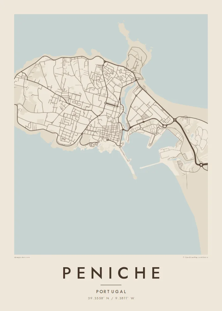
The headland is almost entirely surrounded by the Atlantic, making its coastline the most powerful shape on the map.
Minimalistische kaartposter · Portugal
39.3558° N / 9.3811° W
A fishing town on a rocky peninsula, almost surrounded by the Atlantic, with a fortress and harbour facing the mainland.


Eén stad, vijf sferen
Tik op een stijl om hem aan de muur te zien. Elke stijl kost hetzelfde — geprint, ingelijst of als HD-bestanden.
 Werkelijke pixels · 24 × 36″ printbestand
Haarscherp gedrukt
Dit is een uitsnede op ware grootte van het echte printbestand. Elke poster — geprint, ingelijst of gedownload — wordt op onze servers gerenderd op 300 DPI, tot 7,200 × 10,800 pixels, zodat zelfs de kleinste straatjes scherp blijven op een print van 24 × 36″.
Aan de muur


De kaart
Peniche occupies a rugged headland on Portugal's west coast, and on a map it is unmistakable: a rounded block of land joined to the mainland by a low isthmus. The old town and harbour sit on the southern side, facing sheltered water, while the northern and western shores are cliffs and rocky coves. At the western tip lies Cabo Carvoeiro, and further out the Berlengas islands.
Peniche was once an island, gradually connected to the mainland by sand and sediment. Its sixteenth-century fortress later served as a political prison under the Estado Novo regime, famously the scene of an escape by opposition leader Álvaro Cunhal in 1960, and now houses a museum of resistance and freedom. Today the town is also known for surfing, especially at Supertubos beach.
A Peniche map poster shows this dramatic geography in a single frame. The peninsula's outline, the walls of the old town, the harbour basin and the beaches along the isthmus create a composition with water on almost every side. It is one of those places where the coastline alone tells the story.
The headland is almost entirely surrounded by the Atlantic, making its coastline the most powerful shape on the map.
On the southern shore, the fortress and fishing harbour face the mainland, with the old town packed tightly behind them.
Long sandy beaches, including Supertubos, run along the low neck of land joining Peniche to the rest of Portugal.
Maak hem persoonlijk
Voeg een datum, een naam of je eigen tekst toe, en wissel van stijl, formaat of oriëntatie.
De gratis voorbeeldweergave is lage resolutie met watermerk. Prints en HD-bestanden worden gerenderd op 300 DPI, tot 7,200 × 10,800 px, zonder watermerk.
Waarom Peniche
Surfers, sailors and anyone who has watched the sun set over Cabo Carvoeiro will understand the appeal. Peniche's coastline makes a bold, clear image that works in any room.
You can add a title, a subtitle such as the date of a trip, and coordinates, then choose Classic black & white, Noir, Paper, Blueprint or Sand. Six print sizes come as PNG and PDF for $9.
Bestel de poster Peniche| Printformaat | Resolutie | Bestanden |
|---|---|---|
| 30 × 40 cm11.8 × 15.7″ | 3,543 × 4,724 px | PNG · PDF |
| 29.7 × 42 cm (A3)11.7 × 16.5″ | 3,508 × 4,961 px | PNG · PDF |
| 42 × 59.4 cm (A2)16.5 × 23.4″ | 4,961 × 7,016 px | PNG · PDF |
| 45.7 × 61 cm18 × 24″ | 5,400 × 7,200 px | PNG · PDF |
| 50 × 70 cm19.7 × 27.6″ | 5,906 × 8,268 px | PNG · PDF |
| 61 × 91.4 cm24 × 36″ | 7,200 × 10,800 px | PNG · PDF |
Ter vergelijking: de gratis preview is 900 px breed, heeft een watermerk en is bedoeld voor schermen. De HD-bestanden hebben tot 8× de resolutie in elke richting en worden haarscherp geprint op volledig posterformaat.
Kies bovenaan de pagina een stijl en kies dan voor Geprinte Poster — een formaat en eventueel een lijst — of Digitale HD-bestanden. Afrekenen kost één stap, en je bestelpagina wordt direct bijgewerkt zodra de betaling is verwerkt.
Hij wordt geprint op premium mat papier van 200 g/m² in een van zes formaten, van 30 × 40 cm tot 24 × 36″. Geprinte posters beginnen vanaf $39, verzending inbegrepen.
Ja. Kies een massief houten lijst in zwart, wit, natuurlijk eiken of donker hout. Inclusief breukvast glas en direct op te hangen. Ingelijste posters beginnen vanaf $99, verzending inbegrepen.
Verzending is gratis naar 60+ landen. Elke poster wordt gedrukt door de dichtstbijzijnde van onze drukpartners in 30+ landen en komt meestal binnen 3–7 werkdagen aan. Je volgt de status en de tracking onder Mijn bestellingen. In een paar landen duurt het 2–5 weken, en als we nog niet naar jouw land verzenden, laat de site dat zien voordat je betaalt.
Stuur ons binnen 14 dagen na levering een foto en we printen hem gratis opnieuw of betalen je terug.
Ja. Pas in de editor op deze pagina de titel, de ondertitel en de coördinatenregel aan zoals je wilt, en kies een stijl en formaat. Geprinte, ingelijste en digitale bestellingen gebruiken allemaal precies jouw ontwerp.
Voor $9 krijg je PNG-bestanden op 300 DPI en printklare PDF's in alle zes formaten, zonder watermerk, om overal te printen. Nog niet zeker? Download eerst een gratis voorbeeld met watermerk.
