River confluence
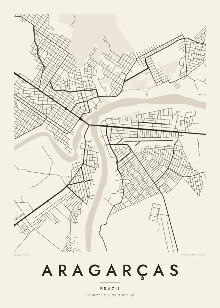
The Araguaia and the Garças meet at the edge of town, and their junction forms the most dramatic shape on the map, two broad channels merging into one.
Positala ya mapu yosavuta · Brazil
15.8975° S / 52.2508° W
A river-border town where the Araguaia meets the Garças, joined by bridge to Mato Grosso on the opposite bank.




Mzinda umodzi, mawonekedwe asanu
Khudzani sitayelo kuti muwone pa khoma. Masitayelo onse amawononga ndalama zofanana — zosindikizidwa, zokutidwa mu chimango kapena ngati mafayilo a HD.
 Ma pixel enieni · fayilo yosindikiza 24 × 36″
Yowala posindikiza
Awa ndi chithunzi 100% chodulidwa cha fayilo yeniyeni yosindikiza. Poster iliyonse — yosindikizidwa, yokutidwa mu chimango kapena yotsitsidwa — imapangidwa pa maseva athu pa 300 DPI, mpaka ma pixel 7,200 × 10,800, choncho ngakhale misewu yaying'ono kwambiri imakhalabe yowoneka bwino pa kope la 24 × 36″.
Pakhoma


Mapu
Aragarças stands in western Goiás where two rivers meet, the Araguaia and the Garças, and its name joins theirs. Across the water lies Barra do Garças in Mato Grosso, so the map shows a twin-town arrangement divided by rivers and a state boundary, with a bridge stitching the two sides together.
The Araguaia is one of central Brazil's great rivers, wide and sandy-banked, and here it forms the town's defining edge. The street grid sits on the Goiás side, squared off where the land is flat and interrupted where it meets the curving riverbanks. From above, the contrast between straight urban lines and broad open water is striking.
In the 1940s Aragarças served as a base for the Roncador-Xingu expedition, which pushed deep into the Brazilian interior. An Aragarças map poster draws the confluence, the bridge and the grid in one frame, giving a precise picture of a frontier town whose shape is decided by rivers and a state line.
The Araguaia and the Garças meet at the edge of town, and their junction forms the most dramatic shape on the map, two broad channels merging into one.
A bridge crosses the river to Barra do Garças, a single line linking two states and turning neighbouring towns into one connected composition.
On the Goiás bank the streets form a regular grid that ends abruptly at the water, where sandy banks and wide curves take over.
Ipangeni yanu
Onjezani tsiku, dzina kapena mawu anu, sinthani mawonekedwe, kukula kapena momwe yaimira.
Chitsanzo chaulere ndi chotsika mu resolution ndipo chili ndi chizindikiro chothira madzi. Zosindikizidwa ndi mafayilo a HD zimapangidwa pa 300 DPI, mpaka ma px 7,200 × 10,800, popanda chizindikiro chothira madzi.
Chifukwa chiyani Aragarças
Aragarças speaks to anyone who has fished the Araguaia, spent holidays on its river beaches or grown up moving between the two states. Water and grid together make a map with a strong, graphic presence on any wall.
Personalise the title, subtitle and coordinates line, and choose Classic black & white, Noir, Paper, Blueprint or Sand, with Blueprint making the rivers especially bold. Download 300 DPI files in six sizes for $9, or order a matte print from our partners.
Odara poster ya Aragarças| Kukula kosindikiza | Mphamvu ya chithunzi | Mafayilo |
|---|---|---|
| 30 × 40 cm11.8 × 15.7″ | 3,543 × 4,724 px | PNG · PDF |
| 29.7 × 42 cm (A3)11.7 × 16.5″ | 3,508 × 4,961 px | PNG · PDF |
| 42 × 59.4 cm (A2)16.5 × 23.4″ | 4,961 × 7,016 px | PNG · PDF |
| 45.7 × 61 cm18 × 24″ | 5,400 × 7,200 px | PNG · PDF |
| 50 × 70 cm19.7 × 27.6″ | 5,906 × 8,268 px | PNG · PDF |
| 61 × 91.4 cm24 × 36″ | 7,200 × 10,800 px | PNG · PDF |
Poyerekeza, chithunzi chaulere ndi cha 900 px m'lifupi, chili ndi chizindikiro ndipo ndi cha pa sikirini. Mafayilo a HD ali ndi mphamvu yochulukira mpaka 8× mbali iliyonse ndipo amasindikizika bwino pa kukula konse kwa positala.
Sankhani sitayelo kumtunda kwa tsamba, kenako musankhe Poster Yosindikizidwa — kukula ndi, mukafuna, chimango — kapena Mafayilo a Digital HD. Kulipira kumatenga sitepe imodzi, ndipo tsamba la oda yanu limasinthidwa nthawi yomweyo pambuyo pa kulipira.
Imasindikizidwa pa pepala labwino la matte la 200 gsm mu kukula kumodzi mwa zisanu ndi chimodzi, kuyambira 30 × 40 cm mpaka 24 × 36″. Maposita osindikizidwa amayamba pa $39, kutumiza kuphatikizidwa.
Inde. Sankhani chimango cha mtengo wolimba mu utoto wakuda, woyera, oak wachilengedwe kapena mtengo wakuda. Chimabwera ndi galasi losathyoka ndipo chikonzekera kupachikidwa nthawi yomweyo. Maposita a mu chimango amayamba pa $99, kutumiza kuphatikizidwa.
Kutumiza ndi kwaulere kumayiko oposa 60. Positala iliyonse imasindikizidwa ndi mnzathu wosindikiza wapafupi kwambiri mwa anzathu m'mayiko oposa 30, ndipo nthawi zambiri imafika m'masiku 3–7 antchito. Mukhoza kutsatira momwe oda ilili ndi malo ake pa "Maoda Anga". Mayiko ena amatenga masabata 2–5, ndipo kumene sitinayambe kutumiza, tsambali likuuzani musanalipire.
Titumizireni chithunzi masiku 14 kuchokera pa tsiku la kutumiza ndipo tidzaisindikizanso kwaulere kapena kukubwezerani ndalama zanu.
Inde. Mu chida chokonzera pa tsambali, sinthani mutu, mutu wowonjezera ndi mzere wa ma coordinates kukhala chilichonse chomwe mufuna, ndipo sankhani sitayelo ndi kukula. Maoda osindikizidwa, a mu chimango ndi a digital onse amagwiritsa ntchito kapangidwe kanu enieni.
Pa $9 mumalandira mafayilo a PNG a 300 DPI ndi PDF okonzeka kusindikiza mu kukula konse kwa zisanu ndi chimodzi, popanda chizindikiro chothira madzi, kuti musindikize kulikonse. Simunatsimikize? Tsitsani kaye chitsanzo chaulere chokhala ndi chizindikiro chothira madzi.
Pafupi
