The Presqu'île
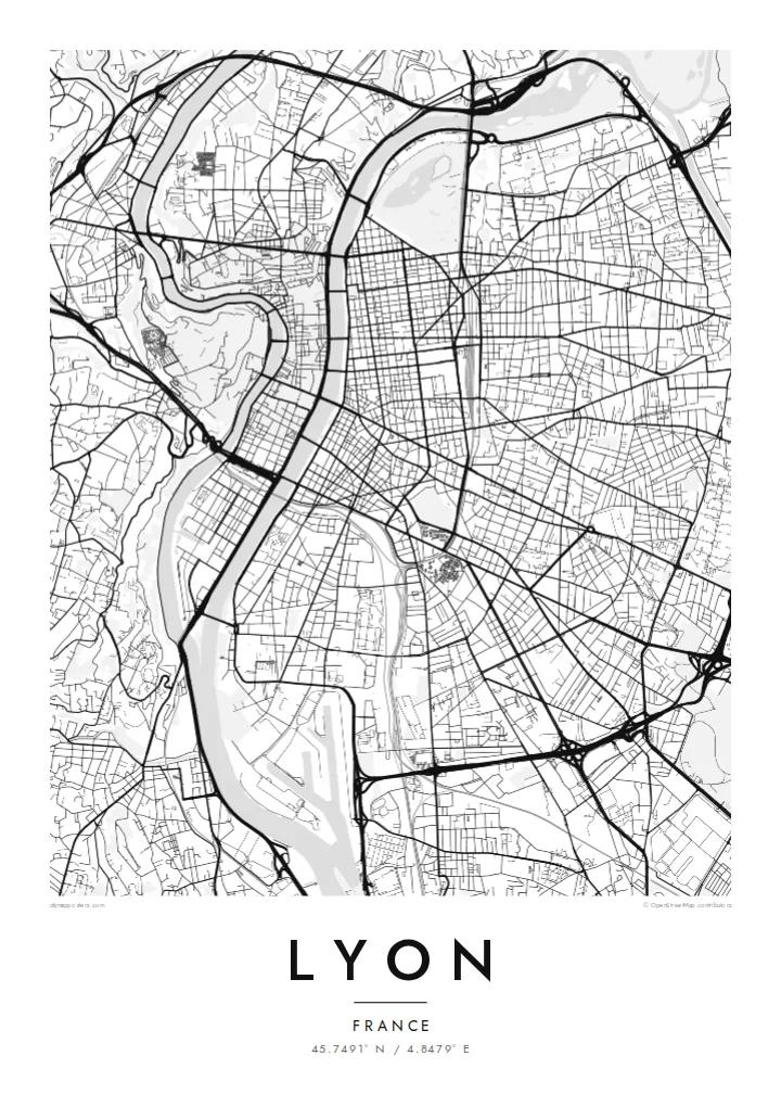
The peninsula between the Rhône and Saône holds a dense, elongated centre with Place Bellecour at its heart, framed on both sides by quays and a steady rhythm of bridges.
Positala ya mapu yosavuta · France
45.7491° N / 4.8479° E
Two rivers, two hills and a narrow peninsula between them: the Rhône and Saône give Lyon one of France's clearest city maps.


Mzinda umodzi, mawonekedwe asanu
Khudzani sitayelo kuti muwone pa khoma. Masitayelo onse amawononga ndalama zofanana — zosindikizidwa, zokutidwa mu chimango kapena ngati mafayilo a HD.
 Ma pixel enieni · fayilo yosindikiza 24 × 36″
Yowala posindikiza
Awa ndi chithunzi 100% chodulidwa cha fayilo yeniyeni yosindikiza. Poster iliyonse — yosindikizidwa, yokutidwa mu chimango kapena yotsitsidwa — imapangidwa pa maseva athu pa 300 DPI, mpaka ma pixel 7,200 × 10,800, choncho ngakhale misewu yaying'ono kwambiri imakhalabe yowoneka bwino pa kope la 24 × 36″.
Pakhoma


Mapu
Lyon is built where the Saône meets the Rhône, and the two rivers give the city an unusually legible shape. Between them runs the Presqu'île, a long, narrow peninsula that holds the historic commercial centre, Place Bellecour and the Hôtel de Ville. At its southern tip, the former docklands of Confluence have been rebuilt as a modern district where the two rivers meet.
West of the Saône, Fourvière hill rises steeply above Vieux Lyon. Its basilica can be seen from across the city, and its slopes hold the remains of Roman Lugdunum, once a capital of Gaul. North of the Presqu'île, the Croix-Rousse hill was home to the silk weavers, whose covered passageways, the traboules, still run through buildings and courtyards. The historic centre is a UNESCO World Heritage Site.
East of the Rhône the city opens into a broader grid, and Parc de la Tête d'Or, one of the largest urban parks in France, curves along the riverbank. A Lyon map poster shows all of this at once: bridges linking the banks, hills pressing against the old town and the orderly east bank spreading toward the plain.
The peninsula between the Rhône and Saône holds a dense, elongated centre with Place Bellecour at its heart, framed on both sides by quays and a steady rhythm of bridges.
On the west bank, the medieval streets of Vieux Lyon are squeezed between the Saône and the steep slope of Fourvière, where winding roads climb to the basilica.
The large park on the left bank of the Rhône shows as a broad open area with a lake, a clear green anchor against the regular blocks of the east side.
Ipangeni yanu
Onjezani tsiku, dzina kapena mawu anu, sinthani mawonekedwe, kukula kapena momwe yaimira.
Chitsanzo chaulere ndi chotsika mu resolution ndipo chili ndi chizindikiro chothira madzi. Zosindikizidwa ndi mafayilo a HD zimapangidwa pa 300 DPI, mpaka ma px 7,200 × 10,800, popanda chizindikiro chothira madzi.
Chifukwa chiyani Lyon
People come to Lyon to study, eat and work, and many stay longer than planned. A map of its rivers and hills is a quiet reminder of an apartment on the Croix-Rousse slope, a café on the Presqu'île or a first job near Part-Dieu station.
Set the title and subtitle to anything you like, from an arrondissement to the day you arrived, and edit the coordinates line. Each of the five styles, Classic black & white, Noir, Paper, Blueprint and Sand, shows Lyon's rivers differently. HD files cost $9, and prints ship from partners in 30+ countries.
Odara poster ya Lyon| Kukula kosindikiza | Mphamvu ya chithunzi | Mafayilo |
|---|---|---|
| 30 × 40 cm (11.8 × 15.7″) | 3,543 × 4,724 px | PNG · PDF |
| 29.7 × 42 cm (A3, 11.7 × 16.5″) | 3,508 × 4,961 px | PNG · PDF |
| 42 × 59.4 cm (A2, 16.5 × 23.4″) | 4,961 × 7,016 px | PNG · PDF |
| 45.7 × 61 cm (18 × 24″) | 5,400 × 7,200 px | PNG · PDF |
| 50 × 70 cm (19.7 × 27.6″) | 5,906 × 8,268 px | PNG · PDF |
| 61 × 91.4 cm (24 × 36″) | 7,200 × 10,800 px | PNG · PDF |
Poyerekeza, chithunzi chaulere ndi cha 900 px m'lifupi, chili ndi chizindikiro ndipo ndi cha pa sikirini. Mafayilo a HD ali ndi mphamvu yochulukira mpaka 8× mbali iliyonse ndipo amasindikizika bwino pa kukula konse kwa positala.
Sankhani sitayelo kumtunda kwa tsamba, kenako musankhe Poster Yosindikizidwa — kukula ndi, mukafuna, chimango — kapena Mafayilo a Digital HD. Kulipira kumatenga sitepe imodzi, ndipo tsamba la oda yanu limasinthidwa nthawi yomweyo pambuyo pa kulipira.
Imasindikizidwa pa pepala labwino la matte la 200 gsm mu kukula kumodzi mwa zisanu ndi chimodzi, kuyambira 30 × 40 cm mpaka 24 × 36″. Maposita osindikizidwa amayamba pa $39, kutumiza kuphatikizidwa.
Inde. Sankhani chimango cha mtengo wolimba mu utoto wakuda, woyera, oak wachilengedwe kapena mtengo wakuda. Chimabwera ndi galasi losathyoka ndipo chikonzekera kupachikidwa nthawi yomweyo. Maposita a mu chimango amayamba pa $99, kutumiza kuphatikizidwa.
Kutumiza ndi kwaulere padziko lonse lapansi. Positala iliyonse imasindikizidwa ndi mnzathu wosindikiza wapafupi kwambiri mwa anzathu m'maiko opitirira 30 ndipo nthawi zambiri imafika m'masiku antchito 3–7. Mukhoza kuona momwe zilili ndi kutsata positalayo pa Maoda Anga. Maiko ena amatenga masabata 2–5, ndipo kumene sitinayambe kutumiza, tsambali limakuuzani musanalipire.
Titumizireni chithunzi masiku 14 kuchokera pa tsiku la kutumiza ndipo tidzaisindikizanso kwaulere kapena kukubwezerani ndalama zanu.
Inde. Mu chida chokonzera pa tsambali, sinthani mutu, mutu wowonjezera ndi mzere wa ma coordinates kukhala chilichonse chomwe mufuna, ndipo sankhani sitayelo ndi kukula. Maoda osindikizidwa, a mu chimango ndi a digital onse amagwiritsa ntchito kapangidwe kanu enieni.
Pa $9 mumalandira mafayilo a PNG a 300 DPI ndi PDF okonzeka kusindikiza mu kukula konse kwa zisanu ndi chimodzi, popanda chizindikiro chothira madzi, kuti musindikize kulikonse. Simunatsimikize? Tsitsani kaye chitsanzo chaulere chokhala ndi chizindikiro chothira madzi.
