Castle ridge
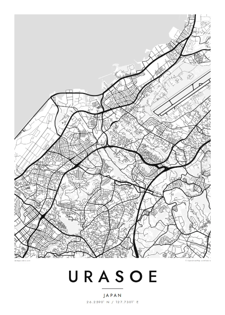
The site of Urasoe Castle and the nearby royal tombs sit on a wooded limestone ridge. It leaves a green gap in the urban fabric that the roads bend around.
Positala ya mapu yosavuta · Japan
26.2590° N / 127.7301° E
A hilly Okinawan city between the East China Sea and a limestone ridge crowned by an old castle site


Mzinda umodzi, mawonekedwe asanu
Khudzani sitayelo kuti muwone pa khoma. Masitayelo onse amawononga ndalama zofanana — zosindikizidwa, zokutidwa mu chimango kapena ngati mafayilo a HD.
 Ma pixel enieni · fayilo yosindikiza 24 × 36″
Yowala posindikiza
Awa ndi chithunzi 100% chodulidwa cha fayilo yeniyeni yosindikiza. Poster iliyonse — yosindikizidwa, yokutidwa mu chimango kapena yotsitsidwa — imapangidwa pa maseva athu pa 300 DPI, mpaka ma pixel 7,200 × 10,800, choncho ngakhale misewu yaying'ono kwambiri imakhalabe yowoneka bwino pa kope la 24 × 36″.
Pakhoma


Mapu
Urasoe lies on the west coast of Okinawa Island, directly north of Naha, and on a map the two cities merge into one continuous urban area. The street pattern here is dense but uneven. Narrow lanes wind over low hills, main roads run north–south parallel to the coast, and neighbourhoods fill the gaps in irregular, tightly packed blocks.
Before Shuri became the royal seat, Urasoe was a centre of power on the island. The ruins of Urasoe Castle stand on a ridge in the east of the city, beside the Urasoe Yōdore, royal tombs carved into the cliff. From above, the ridge appears as a green band that the surrounding streets curve around instead of crossing.
Toward the sea the pattern changes. The coastal strip includes a large area of reclaimed and military land, drawn in long straight lines and open spaces that contrast with the fine-grained residential streets inland. An Urasoe map poster brings together the coastline, the ridge and the dense city between them, a place where history sits close to everyday streets.
The site of Urasoe Castle and the nearby royal tombs sit on a wooded limestone ridge. It leaves a green gap in the urban fabric that the roads bend around.
Along the East China Sea, reclaimed land and large institutional sites form broad, regular shapes, very different from the compact neighbourhoods further inland.
Main roads run north–south through the city, linking it to Naha and the centre of the island. They give the dense map a clear sense of direction.
Ipangeni yanu
Onjezani tsiku, dzina kapena mawu anu, sinthani mawonekedwe, kukula kapena momwe yaimira.
Chitsanzo chaulere ndi chotsika mu resolution ndipo chili ndi chizindikiro chothira madzi. Zosindikizidwa ndi mafayilo a HD zimapangidwa pa 300 DPI, mpaka ma px 7,200 × 10,800, popanda chizindikiro chothira madzi.
Chifukwa chiyani Urasoe
Many people who live in Urasoe work in Naha, yet think of this hillside city as their own. It also matters to anyone interested in the early history of the Ryūkyū Kingdom, and the map holds both the everyday and the historical.
Set the title, add a subtitle and a date, or keep the coordinates line as it is. Five styles are available, from Classic black & white to the blue tones of Blueprint and the warm Sand. Order them as HD files for $9 or as a printed poster.
Odara poster ya Urasoe| Kukula kosindikiza | Mphamvu ya chithunzi | Mafayilo |
|---|---|---|
| 30 × 40 cm (11.8 × 15.7″) | 3,543 × 4,724 px | PNG · PDF |
| 29.7 × 42 cm (A3, 11.7 × 16.5″) | 3,508 × 4,961 px | PNG · PDF |
| 42 × 59.4 cm (A2, 16.5 × 23.4″) | 4,961 × 7,016 px | PNG · PDF |
| 45.7 × 61 cm (18 × 24″) | 5,400 × 7,200 px | PNG · PDF |
| 50 × 70 cm (19.7 × 27.6″) | 5,906 × 8,268 px | PNG · PDF |
| 61 × 91.4 cm (24 × 36″) | 7,200 × 10,800 px | PNG · PDF |
Poyerekeza, chithunzi chaulere ndi cha 900 px m'lifupi, chili ndi chizindikiro ndipo ndi cha pa sikirini. Mafayilo a HD ali ndi mphamvu yochulukira mpaka 8× mbali iliyonse ndipo amasindikizika bwino pa kukula konse kwa positala.
Sankhani sitayelo kumtunda kwa tsamba, kenako musankhe Poster Yosindikizidwa — kukula ndi, mukafuna, chimango — kapena Mafayilo a Digital HD. Kulipira kumatenga sitepe imodzi, ndipo tsamba la oda yanu limasinthidwa nthawi yomweyo pambuyo pa kulipira.
Imasindikizidwa pa pepala labwino la matte la 200 gsm mu kukula kumodzi mwa zisanu ndi chimodzi, kuyambira 30 × 40 cm mpaka 24 × 36″. Maposita osindikizidwa amayamba pa $39, kutumiza kuphatikizidwa.
Inde. Sankhani chimango cha mtengo wolimba mu utoto wakuda, woyera, oak wachilengedwe kapena mtengo wakuda. Chimabwera ndi galasi losathyoka ndipo chikonzekera kupachikidwa nthawi yomweyo. Maposita a mu chimango amayamba pa $99, kutumiza kuphatikizidwa.
Kutumiza ndi kwaulere padziko lonse lapansi. Positala iliyonse imasindikizidwa ndi mnzathu wosindikiza wapafupi kwambiri mwa anzathu m'maiko opitirira 30 ndipo nthawi zambiri imafika m'masiku antchito 3–7. Mukhoza kuona momwe zilili ndi kutsata positalayo pa Maoda Anga. Maiko ena amatenga masabata 2–5, ndipo kumene sitinayambe kutumiza, tsambali limakuuzani musanalipire.
Titumizireni chithunzi masiku 14 kuchokera pa tsiku la kutumiza ndipo tidzaisindikizanso kwaulere kapena kukubwezerani ndalama zanu.
Inde. Mu chida chokonzera pa tsambali, sinthani mutu, mutu wowonjezera ndi mzere wa ma coordinates kukhala chilichonse chomwe mufuna, ndipo sankhani sitayelo ndi kukula. Maoda osindikizidwa, a mu chimango ndi a digital onse amagwiritsa ntchito kapangidwe kanu enieni.
Pa $9 mumalandira mafayilo a PNG a 300 DPI ndi PDF okonzeka kusindikiza mu kukula konse kwa zisanu ndi chimodzi, popanda chizindikiro chothira madzi, kuti musindikize kulikonse. Simunatsimikize? Tsitsani kaye chitsanzo chaulere chokhala ndi chizindikiro chothira madzi.
